Railroad Forums 

  • 1966 freight sidings Babylon to Patchogue

  • Discussion of the past and present operations of the Long Island Rail Road.
Discussion of the past and present operations of the Long Island Rail Road.

Moderator: Liquidcamphor

 #1578131  by nyandw
 
From MP41-42: View W. East of Saxon Ave and south of the LIRR original main the south siding west of the coal bunker had a new turnout installed for Inspected Transit Mix Co., the cement elevator and siding installed 1957. Abandoned: Sometime in the 1960's? Anyone with a CR4?

Image 
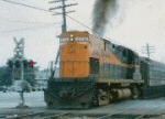
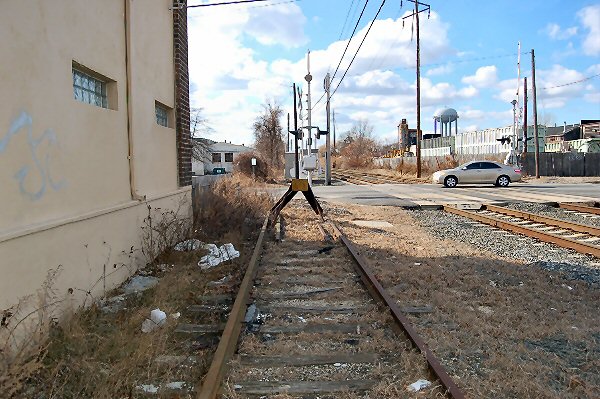
Photo: Steve Lynch 8/2012
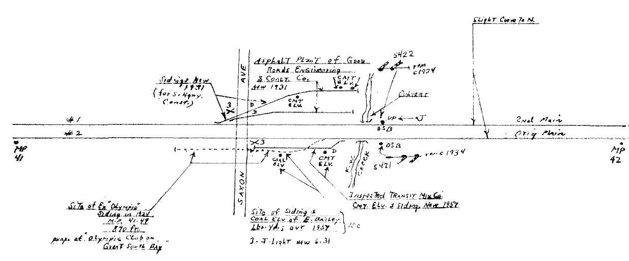
Image
 #1578204  by 452 Card
 
When I was at Babylon in the 80's I met an old Trainmaster. When I told him I hailed from Patchogue, he began to reminice on the freight sidings in PD when he was a trainman. He told me there were 54 switches in the PD area on and off the Main. I didnt count them on the Emery map, but that seems plausible. That would be impossible to model in O gauge unless that is all the layout is.
 #1578232  by nyandw
 
452 Card wrote: Fri Aug 13, 2021 4:46 pm He told me there were 54 switches in the PD area on and off the Main. I didnt count them on the Emery map, but that seems plausible..
Quite true as approx. 20+ industries available at many time frames. I have been working on this chart for historical/modeling purposes to illustrate this area.
Image
 #1578248  by workextra
 
Hi! Nice spread sheet ya got there Steve.
And that’s an impressive list of switches/industries in Patchogue alone that would Make its own model Railroad For someone into heavy switching.

If you could, might I suggest you do the spread sheet in accordance by branch. You could in the one file have additional
Sheets, duplicate the format over then fill in the industries and other necessary information.
That’s a very good think to have it all in one place!
Looking at the alignment of the structures North of the single track at Bay Ave in Patchogue (S-54) I cannot clearly see the trajectory of the telephone switch as being a eastbound facing move. I could me missing the alignment through the brush.
I don’t want to stray too far but could we get some data on a potential consigned east of MP 55 but before the first grade crossing. Looks like there is a eastbound facing move into a siding north of the main just around the bend.
It may have been gone by 1966 not sure.
 #1578267  by nyandw
 
workextra wrote: Sat Aug 14, 2021 1:30 pmHi! Nice spread sheet ya got there Steve.
And that’s an impressive list of switches/industries in Patchogue alone that would Make its own model Railroad For someone into heavy switching.

I've been working on an article concerning this very topic!

If you could, might I suggest you do the spread sheet in accordance by branch. You could in the one file have additional Sheets, duplicate the format over then fill in the industries and other necessary information.

An awesome task. Depending on the year(s) things change, for example. I don't have intimate knowledge except the Babylon-Patchogue Scoot area where I grew up. It would be a "labor of love" project.

Looking at the alignment of the structures North of the single track at Bay Ave in Patchogue (S-54) I cannot clearly see the trajectory of the telephone switch as being a eastbound facing move. I could me missing the alignment through the brush.

I hope the maps posted help.
 #1580087  by interface76
 
workextra wrote: Thu Aug 12, 2021 12:20 am Steve,
Thanks, direct south of M2 at the same location, Saxon. There’s a bumper block in the under brush and some track maybe 2 cars. Appears to be a box car industry unless the building was built later on. This switch might have lasted into the MTA.
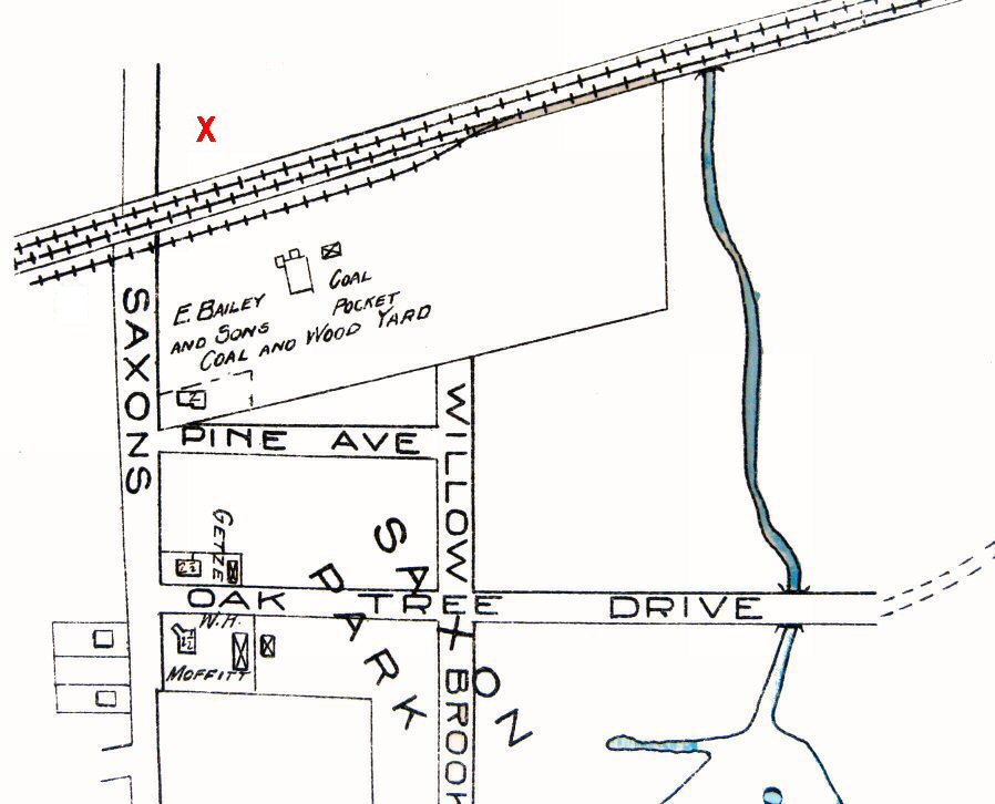
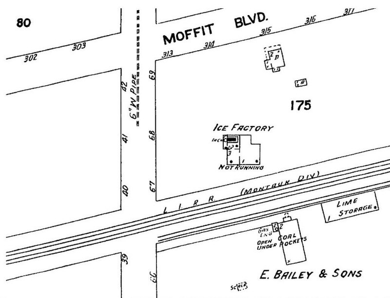
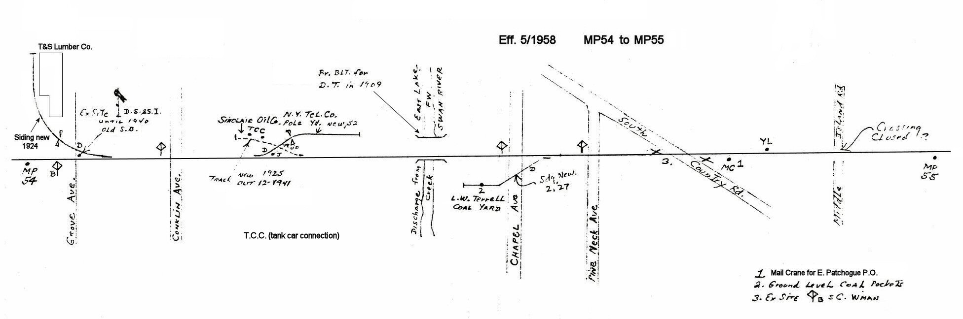
I grew up near that crossing, so I can offer some thoughts. I used to sit along the siding when I rode my bike down to the Saxon Ave crossing and watched one or two passages of a push-pull in the 80's.

It was called "Olympic Siding", and runs alongside the school bus yard and repair shop. I don't know what was there before, and I don't ever remember seeing anything parked on it in my lifetime (Born in 1976). The switch was in place for a long time as I recall, and was severed in the late 90's early 00's maybe? It was when the concrete tie /welded rail installation project was going on. My guess is around the same time as the high platforms going in.

The siding and bumper block are there to this day, heavily overgrown.
 #1580093  by nyandw
 
The siding was for the use of the Olympic Club, on the Great South Bay funded by William H. Moffitt, a member of the Olympic Club and a real estate developer. Located on the south side of the tracks and crossing Saxon Ave. Read on:

Image
The Ice factory building would be located (red X) on this 1915 Hyde map Islip segment, below: The Olympic siding was located .27 miles west of Islip station, based upon mileage indicated in the 1913 and 1919 CR4. It was for the use of the Olympic Club, funded by William Moffitt, on the Great South Bay. It was on the south side of the tracks and crossed Saxon Ave.

By 1914, Moffitt was said to have been worth over $2 million and had bought and sold over $20 million in property. He had become a distinguished businessman whose company and accomplishments had been praised in the papers. However, the real estate industry began to decline and Moffitt found himself so greatly indebted he sold his home on Orowoc Pond to Walter G. Oakman, (who in 1918 sold it to George Graham, a senior member of the U.S. House of Representatives) in order to pay his mortgage. Moffitt was also forced to sell a factory he owned in Bay Shore and continued to sell off his assets for the next three years to make ends meet.

Unable to pay back creditors, Moffitt fled to California and then became a fugitive. He had been indicted back in New York with a grand larceny charge as a result of real estate deals totaling $4 million and chose to not appear. Moffitt also spent time hiding in London but did come back to the United States where he was finally arrested and investigated. Eventually, Moffitt was able to pay back his creditors and returned to California where he established another real estate business in the 1920’s. All that was remembered of Moffitt however back in New York was Moffitt Boulevard located in Bay Shore.

His estate eventually became the new Islip High/Middle School location by the lake behind McDonalds on Main Street when it opened 1965 when I attended.

My “guess” with Moffitt in deep trouble financially, but the siding still in place for another 10 years until 1924. The LIRR may have spotted freight cars there for Baileys and a load for the Ice Company (team track style!?) across the street for wagon pickup. Similar to Grinnell Lithograph on Moffitt Blvd over in the area across from the Islip Freight station/later team track. Info: Steven Lynch

Image
Schlemmer Ice Co, and Bailey's Mill Islip - Sanborn map 4/1925 Note: The 'Olympic siding' has been cut back to east of Saxon Ave. and the Schlemmer Ice Co. 'not running
 #1580107  by nyandw
 
Since the original b/w linear single track this has morphed into a major project. Babylon to Patchogue+ is being worked on c.1960. Here's a sneak peek at Islip in keeping with the favor of the previous material:
Yellow = existing
Red = no longer in use. Islip Station razed 12/ 1963
Green Islip Station = active 1963
Image

Yes, hard to read, but you get the idea as we work the entire MP37-56 area!
 #1580487  by nyandw
 
workextra wrote: Wed Aug 11, 2021 12:41 am Found what appears to be a siding a bit west of Frank bros also north of no1 track. Does anyone have photos showing the siding by mp54 in Patchogue?
West of Frank Bros was Regent Cigarette Co. in Bay Shore. MP54 Patchogue, T&S Lumber siding in 1924, per Emery, crossing Grove Ave. When razed???