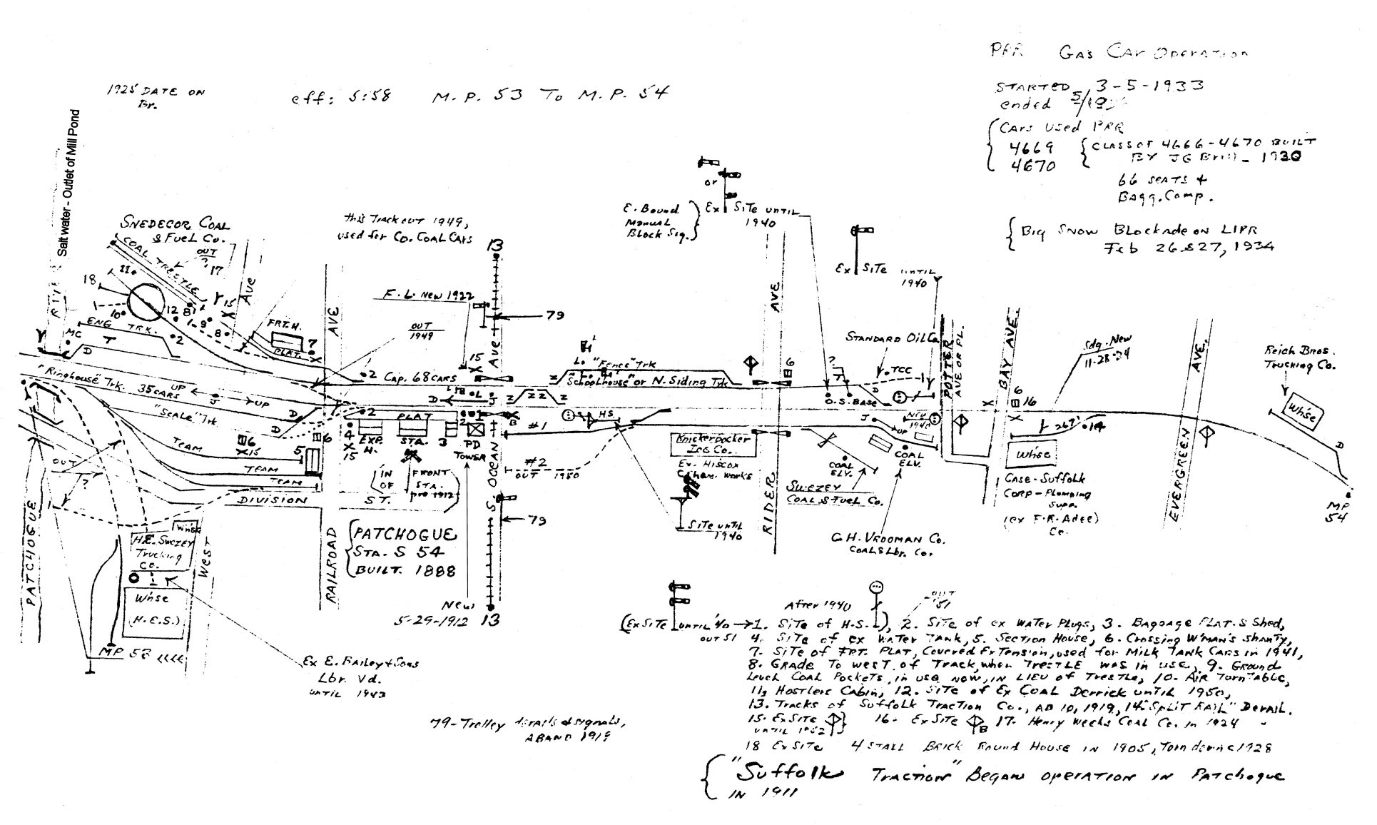
Railroad Forums 

  • 1966 freight sidings Babylon to Patchogue

  • Discussion of the past and present operations of the Long Island Rail Road.
Discussion of the past and present operations of the Long Island Rail Road.

Moderator: Liquidcamphor

 #1577784  by workextra
 
Nice map. Can we edit it to show show track designation and.

Where was Islip coal? Was the switch closer to the station east of MP42 or further west, closer to MP41? (By the scrap place today)

The consignees in Bayport there is remains today of one west of the former station north of the main, but absolutely no evidence of 2 switches off the main there.
I do believe there was a Secondary track between PD & Y I saw photos showing this at one time.
Frank Bros is still there by MP39 and appears to be very distressed do we have photos of the coal trestle and or use of the property there?
Perfect scene to model.
Today they operate east of bay shore north of the main as a fuel oil dealer.
 #1577837  by nyandw
 
workextra wrote: Mon Aug 09, 2021 11:04 am Nice map. Can we edit it to show show track designation and.
Yes edit and send to me or post!

Where was Islip coal? Was the switch closer to the station east of MP42 or further west, closer to MP41? (By the scrap place today) just west of station: Image
 #1577845  by workextra
 
Hi! Thanks for the map I took a look earlier. By Saxon Ave there was a consignees South of Mtk 2 the track and block is still there. Switch is gone today STS (buses) use the facility.
In the same location directly north of M1 there is this old building that looks perfectly to be a coal yard office.
Any statistics on this?
Maybe these were gone by ‘66?

Frank Bros don’t take cars at their current location north of and east of Bayshore team, the latter is still useable on its west end
The lumber yard tracks are gone. As is the east switch back into M2.

No evidence of any freight between Islip station and Oakdale team
Sayville team is now MoW yard and the lumber yard track is there but disconnected and under ties and other track Material MP49 is there behind the crossing bungalow
The lead for the industry at Bayport north of is the single track is still there in the bushes.
Bluepoint team (site is freight house/station) now used for Tie and track material storage by engineering.
Very difficult to see remains of the relight sidings just east of Patchogue except for Sweesey fuel co. The other sites are there but if your not good at detecting the former ROW you won’t find them
 #1577846  by nyandw
 
workextra wrote: Mon Aug 09, 2021 11:16 pm Any statistics on this? Maybe these were gone by ‘66? LIRR car load reports needed, anyone?

Yes, last customer was Islip Coal last coal hoppers, perhaps late 1950's as conversion to fuel oil was rapid.

LIRR Car Load Reports, last I have is 1977. Anyone with earlier?


No evidence of any freight between Islip station and Oakdale team Yes
 #1577932  by MACTRAXX
 
Steve: Interesting 1966 Montauk Branch map of the Babylon (36.6) and Patchogue (53.9) segment.
(Mileages from LI City) showing the various sidings and freight spurs in the mid 1960s.

This map omitted two passenger stations: Great River (45.2) and Blue Point (52.6)

From a 5/25/1970 LIRR ETT: (for reference)
Babylon 36.6
Bay Shore 40.7
Islip 43.1
Great River 45.2
Oakdale 47.4
Sayville 49.8
Y Interlocking (end of double track) 50.6
Bayport 51.5
Blue Point 52.6
Patchogue 53.9 (PD Tower and Station Signals)

Train Speeds (MPH):
Babylon and Y - both tracks: 65 passenger, 45 freight.
Except - Second curve west of Oakdale: 60 passenger.

Y and PD (single track) 65 passenger, 45 freight.
Except: First curve east of Bayport: 60 passenger.
Yard Limit board 2925 feet west of M.P. 53 and PD: 40 mph.

Glad to assist with this added information...MACTRAXX
 #1577953  by 452 Card
 
No photo, but I do have a mental image from the wayback of Case Plumbing Supply. It was located on the corner of Bay Avenue and Norton Street south of the track. I remember a green loading dock for trucks facing south on Norton Street.
They supplied heavy cast-iron plumbing material before PVC existed, hence the siding.
The switch to the north to NY Tel. is no longer there but the building is still there as a telecom company. The switch led into a large area now occupied by a major rigging company, which has spread to both sides of the track into what was Case Supply.
 #1578029  by nyandw
 
452 Card wrote: Wed Aug 11, 2021 7:03 am No photo, but I do have a mental image from the wayback of Case Plumbing Supply. It was located on the corner of Bay Avenue and Norton Street south of the track. I remember a green loading dock for trucks facing south on Norton Street.
They supplied heavy cast-iron plumbing material before PVC existed, hence the siding.
The switch to the north to NY Tel. is no longer there but the building is still there as a telecom company. The switch led into a large area now occupied by a major rigging company, which has spread to both sides of the track into what was Case Supply.

View W Image


View E Image

Emery map 1958: Image
 #1578030  by nyandw
 
MACTRAXX wrote: Tue Aug 10, 2021 10:40 pm Steve: Interesting 1966 Montauk Branch map of the Babylon (36.6) and Patchogue (53.9) segment.
(Mileages from LI City) showing the various sidings and freight spurs in the mid 1960s.
This map omitted two passenger stations: Great River (45.2) and Blue Point (52.6)
Glad to assist with this added information...MACTRAXX
I omitted Great River and Blue Point as not freight siding.. should I add them?
Would you guys like to see double track and added info you provide? Please edit and I'll revise.
 #1578035  by nyandw
 
workextra wrote: Mon Aug 09, 2021 11:16 pm Hi! Thanks for the map I took a look earlier. By Saxon Ave there was a consignees South of Mtk 2 the track and block is still there. Switch is gone today STS (buses) use the facility.
In the same location directly north of M1 there is this old building that looks perfectly to be a coal yard office.
Any statistics on this? Maybe these were gone by ‘66?
Yes

Go here as many changes over the century!: http://www.trainsarefun.com/lirr/islip/islip.htm
 #1578038  by nyandw
 
In the same location directly north of M1 there is this old building that looks perfectly to be a coal yard office.

No, but, several other industries at that location: Ice Factory 1909, later after WW II asphalt Co. with an elevator bldg. New sidings for Sunrise Hwy construction materials, but gone prior to 1966. Car Load reports are the key here... :-(
 #1578039  by workextra
 
Steve,
Thanks, direct south of M2 at the same location, Saxon. There’s a bumper block in the under brush and some track maybe 2 cars. Appears to be a box car industry unless the building was built later on. This switch might have lasted into the MTA.