• Where were you on December 22nd 1985?

  • Discussion relating to commuter rail, light rail, and subway operations of the MBTA.
Discussion relating to commuter rail, light rail, and subway operations of the MBTA.

Moderators: sery2831, CRail

  by 3rdrail
 
Here's an early shot of the line. Our car is headed towards Forest Hills on South St. opposite Boynton St. Saint Thomas Aquinas Church is up on the left. It appears to be a staged safety shot, the type of which was common back in the day in promoting safety on and around streetcars. The Jamaica Car House would be off on the left of the photo.
Image
  by mattl
 
Paul,

Thanks for posting these photos. If you have any others, I'd love to see them.

I'd especially like to know if anyone has any information or maps on the exact locations of the old stops and signage used in the old trolley stops.
  by F-line to Dudley via Park
 
mattl wrote:Paul,

Thanks for posting these photos. If you have any others, I'd love to see them.

I'd especially like to know if anyone has any information or maps on the exact locations of the old stops and signage used in the old trolley stops.
Wasn't any signage. For most of its (and the Watertown line's) history stops were marked by an orange stripe on the nearest trolley pole. And possibly some old bus-type signage, which pre-2000's was skeletal and uninformative at best. The stop markers on the street-running portion of the E today are all early-2000's vintage. Of course, people were well-accustomed after nearly a century of operation to pure streetcar service so those vague markers were self-explanatory without need for more elaborate signage.

The "suspended service" spider maps still at many Green Line stations show the stops:

Image

With very few changes in the 25 years since they're exactly where the 39 stops today. All at street corners, middle of the street like the E past Brigham circle today save for Forest Hills where it stopped in Arborway Yard across the street (old Forest Hills didn't have a trolley loop right at the entrance like new Forest Hills). Ditto with the current 57 bus for all the former Watertown stops past Packards Corner.
  by CSX Conductor
 
3rdrail wrote:Here's an early shot of the line. Our car is headed towards Forest Hills on South St. opposite Boynton St. Saint Thomas Aquinas Church is up on the left. It appears to be a staged safety shot, the type of which was common back in the day in promoting safety on and around streetcars. The Jamaica Car House would be off on the left of the photo.
Image
Was Bob's Spa open yet?
  by Adams_Umass_Boston
 
In Paul's picture you can see an advertisement to the left on the front of the trolley for the Nautical Gardens out at Revere Beach.

Here is a post card showing one of the iterations of the Nautical Gardens.
You do not have the required permissions to view the files attached to this post.
  by 3rdrail
 
Hi Guys ! I'm glad that you're enjoying the pics ! I'll be putting more up.

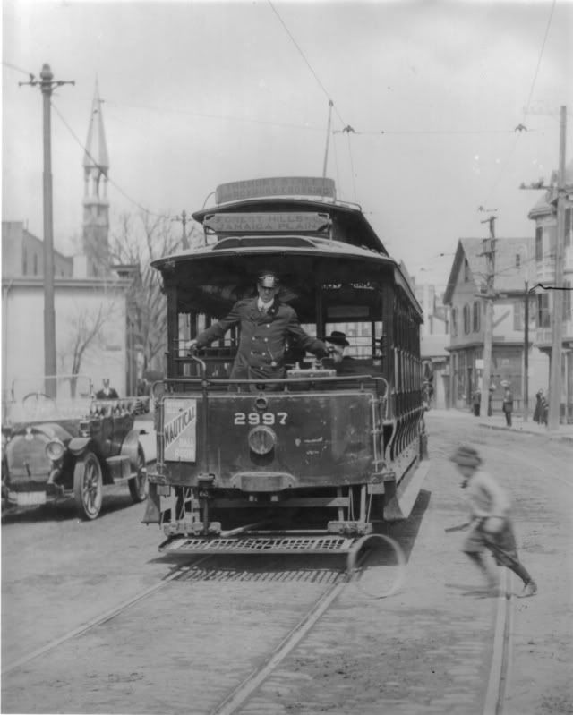
Matt - Understand that these stops were mostly flag stops in that a passenger would either be alighting or indicating that they wanted to board at a designated pole in order for the car to stop. Otherwise, the car would just sail through. The fact that the streetcar's route as well as boarding/alighting often took place in the middle of the street, made this all necessary.

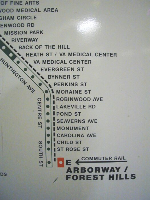
F Line - The Arborway was the terminus for the streetcar line via South/Centre/South Huntington/Huntington into the Central Subway System, however Forest Hills Station was the terminus previously. There was a crossover at Forest Hills where cars could reverse, and the long ride from Cleary Square, Dedham Line, and Charles River did occasionally go through Forest Hills Station on their way to Park Street Station. (Track south of Forest Hills was owned by EMStRyCo and leased to BERy.) So as to not confuse, the current Forest Hills streetcar stop was never used for streetcar service, and in fact has a much different alignment than the original streetcar stop on the lower level inside the original BERy Forest Hills Station.

Rob - I wondered if Nautical Gardens became the old Wonderland Ballroom of which the EBTX station was named ?

CSX - I don't know if Bob's Spa was there or not at the time, but the name sort of suggests it. There were a few "Spas" along the route there, all the same type of ma and pa variety store.

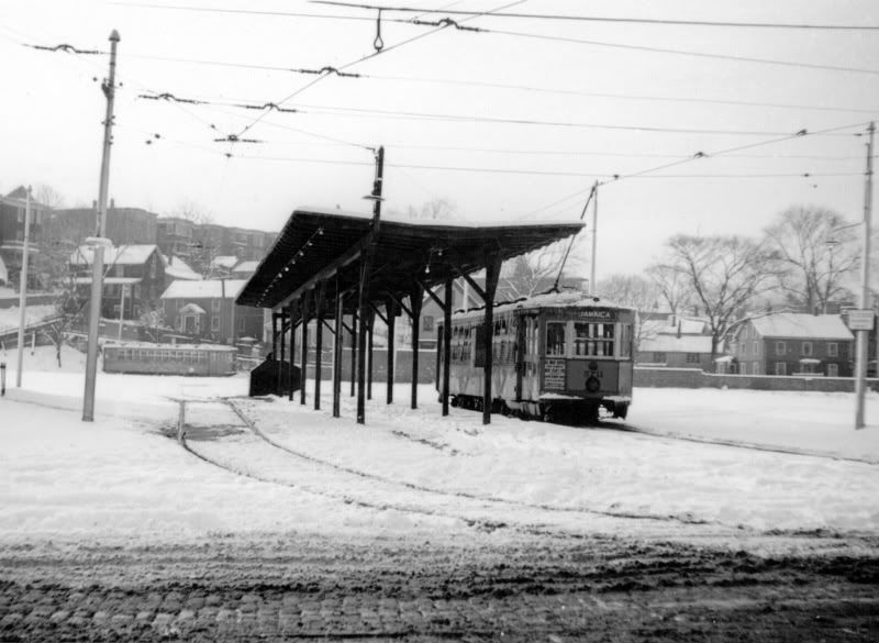
Here's a shot of the platform at the Jamaica Plain Car House, located on South Street accross from McBride, which was itself used as a terminus for some lines. That's St. Rose St. in the background. After the lot was no longer used for streetcars, a BHA housing project went up in it's place. This photo would be left of the safety photo location.
Image
  by 3rdrail
 
mattl wrote:Paul,

Thanks for posting these photos. If you have any others, I'd love to see them.

I'd especially like to know if anyone has any information or maps on the exact locations of the old stops and signage used in the old trolley stops.
Here are the stops as of 1905, Matt, directly from one of my favorite reference books, BERY's "Stopping Place Directory". It may take me a month to get back to you with the definitive answer, but I don't forget ! hahaha!!!
You do not have the required permissions to view the files attached to this post.