Was talking with a guy the other day about Bayway. Brought back memories of when I'd started with CR and I got to see bits of the Sound Shore line. Back then there'd looked to be some decent business on the northern end in the Bayway area along the Kill. The south end still had some business but I didn't have much seniority to get on one of those jobs. Anyone out there know what businesses were along the line? I know the few that are current but couldn't tell you who was there when I started or before. There's not much info on this line on the internet. Know there was a drawbridge over the Rahway river at one point. Me and an old timer took a lite engine up to what was left of it back when I was new to CR. Told me they ended service some time in the 60s. Anyone familiar with this line?
Railroad Forums
Sound Shore
- Pertaining to all railroading subjects, past and present, in New Jersey
Moderator: David
The article "Rule Ninety Three" in a 1950s issue of Railroad Model Craftsman was all about the Sound Shore Branch. I need to dig through the archives to locate the exact issue date.
George in Rochester NY
The Unofficial Micro-Trains Release Report (among other things)
The Unofficial Micro-Trains Release Report (among other things)

Found it... the RMC issue you would want to look for is June 1951. I hadn't looked at it for a while. I should note that I lived in Carteret for 20 years, from 1969 to 1989.
Yes, there was a hand operated draw bridge just about at the mouth of the Rahway River on the Sound Shore Branch, complete with smash boards (!).
According to a map of the branch, these are the industries shown as being along the line as of the article date, going from north to south, along with a few landmarks. I'm not sure whether these were just the main industries or all of them. The branch officially started just south of the Elizabeth River drawbridge as it came off the then double track mainline. The stations noted below were for the passenger service. Somewhere around here I have a passenger train schedule, but that's an archive dig for another day.
- Junction with "Bayway Extension"
- Phelps Dodge
- Bayway Terminal
- Morses Creek Bridge, 1.09 miles from start
- Standard Oil Acid Plant
- Grasselli Station, 2.25 miles
- Grasselli Chemical Works, DuPont
- General Aniline and Film (GAF)
- Connection to "Third Branch" and storage yard; the "Third Branch" also connected to the Elizabeth to Perth Amboy mainline
- Sinclair Oil
- Cities Service
- Warners Station, 3.53 miles
- American Cyanamid
- Drawbridge over Rahway River
- Petroleum Station, 3.97 miles
- American Oil Company
- Fertilizer Plant
- Williams and Clark, grade crossing with the New Jersey Terminal Railroad (I'll come back to that)
- Two Coal Yards, one on each side.
- First crossing of Roosevelt Avenue
[Notably missing from here is FMC, which I know was a customer in the 1960s.]
- Carteret Station, 4.75 miles
- Foster Wheeler - some of this track remains in place though unused
- Lumber yard - I know this was Carteret Lumber and still had service circa 1969-early 1970s, since I personally saw boxcars there
- Second crossing of Roosevelt Avenue. This is currently protected by full crossing flashers that will probably never see another train...
- Leibig's Lane Station, 5.30 miles. This is close to the current location of the Carteret Police Department
- Junction with the New Jersey Terminal
- Joint Sound Shore/NJ Terminal Yard
- Junction with the Reformatory Branch of the CNJ, which ran right through Carteret and bridged over the CNJ Elizabeth to Perth Amboy mainline on its way to points in West Carteret and Woodbridge.
- Double sided water tank, with a spout to the west for the Sound Shore and spout to the east for the NJ Terminal
- Chrome Station, 5.83 miles
- Continuation to the Port Reading Creosote Plant and Yard, and the Port Reading Yard of the Reading. I believe but can't be sure that this track connection was gone by the 1970s.
It's noted in the map that all of the waterfront industries in Carteret, including IT Williams and US Metals, were served off the New Jersey Terminal, not the Sound Shore Branch.
George in Rochester NY
The Unofficial Micro-Trains Release Report (among other things)
The Unofficial Micro-Trains Release Report (among other things)
On further review, thinking about the orientation of the Sound Shore and the New Jersey Terminal, I think that FMC was actually serviced from the NJ Terminal.
If I am orienting things correctly, the Sound Shore ROW now sits under the Carteret Industrial Road, while the line that goes through FMC is the former NJ Terminal.
If I am orienting things correctly, the Sound Shore ROW now sits under the Carteret Industrial Road, while the line that goes through FMC is the former NJ Terminal.
George in Rochester NY
The Unofficial Micro-Trains Release Report (among other things)
The Unofficial Micro-Trains Release Report (among other things)
Great info! Thank you, umtrr-author! Do you have any info on the NJ Terminal RR? I tried a Google search. Only thing that'd kept coming up is the Jersey Central terminal in JC. How long did they operate for? Back when I took some Bayway jobs, I'd see a little engine working what was left of the Sound Shore. Never thought to ask who's train it was. Looked like a little motorized red caboose. Any info on that one? Last saw it, guessing in the late 80s or early 90s.
AceMacSD wrote: ↑Mon Jun 12, 2023 1:56 pm Great info! Thank you, umtrr-author! Do you have any info on the NJ Terminal RR? I tried a Google search. Only thing that'd kept coming up is the Jersey Central terminal in JC. How long did they operate for? Back when I took some Bayway jobs, I'd see a little engine working what was left of the Sound Shore. Never thought to ask who's train it was. Looked like a little motorized red caboose. Any info on that one? Last saw it, guessing in the late 80s or early 90s.Operated until 1905 per this opinion by the NJ Court of Errors and Appeals (the prior equivalent of what is now the NJ Supreme Court since 1947) with the railroad as defendant, which may be of interest: https://cite.case.law/njl/76/684/
~Ken :: Fairmont ex-UP/MP C436 MT-14M1 ::
Black River Railroad Historical Trust :: [/url]
Black River Railroad Historical Trust :: [/url]
AceMack, I was already gone from NJ in 1989, so the best I can do is venture a guess that it was some kind of "Trackmobile" which switched small cuts of cars around for one of the larger industries. That would have been on the north (Linden) side of the Rahway River, right?
Ken... 1905! I think the scanner needed a little help... the "Lehigh Yalley Eailroad" ? I didn't realize that the NJ Terminal had been brought into the CNJ fold that early. I wonder if the Jersey Central had been behind it all along anyway.
Ken... 1905! I think the scanner needed a little help... the "Lehigh Yalley Eailroad" ? I didn't realize that the NJ Terminal had been brought into the CNJ fold that early. I wonder if the Jersey Central had been behind it all along anyway.
George in Rochester NY
The Unofficial Micro-Trains Release Report (among other things)
The Unofficial Micro-Trains Release Report (among other things)
Correct umtrr-author, north side of the Rahway river. I gotta ask the old timers about that operation.
Ken, that's a very interesting court doc. I'd like to see someone try pulling a scam like that these days.
Ken, that's a very interesting court doc. I'd like to see someone try pulling a scam like that these days.
From the December 1951 issue of the Official Guide of the Railways, here is the passenger schedule for the Sound Shore Branch. "Imgur is temporarily over capacity. Please try again later." So here is a link to the image, much larger than I would have been able to upload:
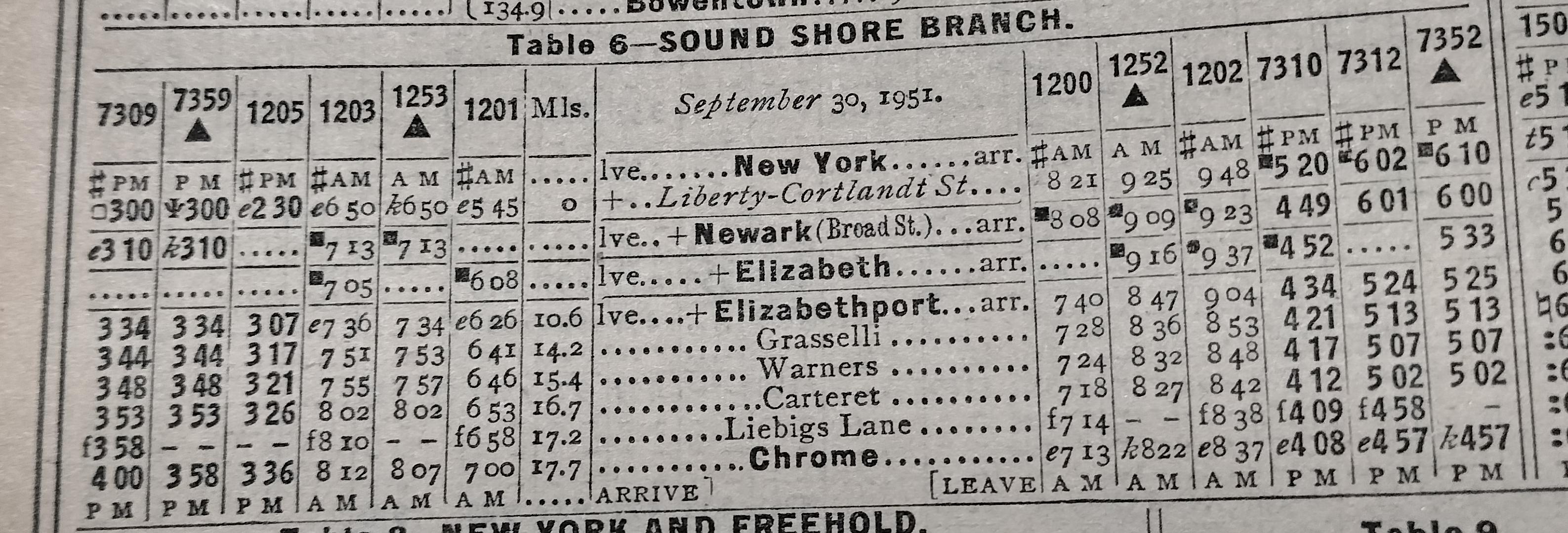
I'm not sure what all of the symbols mean. "f" is definitely "Flag Stop" meaning stopping only when signaled. The pound sign / hashtag "#" I believe means Monday to Friday only service. Note how the trains are aligned to connect with service from New York (really Jersey City), Newark, and Elizabeth, with a change of trains at Elizabethport. Also note how it takes 26 minutes to go seven miles (MP 10.6 to MP 17.7)!
I'm not sure what all of the symbols mean. "f" is definitely "Flag Stop" meaning stopping only when signaled. The pound sign / hashtag "#" I believe means Monday to Friday only service. Note how the trains are aligned to connect with service from New York (really Jersey City), Newark, and Elizabeth, with a change of trains at Elizabethport. Also note how it takes 26 minutes to go seven miles (MP 10.6 to MP 17.7)!
George in Rochester NY
The Unofficial Micro-Trains Release Report (among other things)
The Unofficial Micro-Trains Release Report (among other things)
Very interesting little branch line. Thank you for the info! Back when all thise industries were there this must have been a busy branch. Any record of how many people used Sound Shore service before service ended? Was the Rahway river drawbridge demoed due to lack of service or was there something that damaged the bridge?
I don't know the answer to why the bridge was taken out of service, but just checking Historic Aerials, it was gone some time between 1957 and 1963. The 1963 aerials show the approaches still in the river but the span itself is gone. Google Maps, with a 2023 date, shows just the piers remaining in the water now. Also, a sizable part of a former industry just north of the river and east of the former ROW is just a large field of dirt now. I'm thinking "brownfield."
George in Rochester NY
The Unofficial Micro-Trains Release Report (among other things)
The Unofficial Micro-Trains Release Report (among other things)
It seems that the more you find out the more questions it raises. Some trains took longer than 26 minutes, and there were no meets; whatever went down to Chrome made a quick turn and came back, leaving plenty of time for the local freights to do their work. Did the CNJ ever have doodlebugs? I don't think I've ever seen a photo. And does anybody know what signal system was in effect? Manual block? TT &TO? Automatic block?
Per the June 1951 article in RMC, the Sound Shore Branch was operated using Rule 93, which put the entire branch within a Yard Limit. According to the article, a "positive block" (not an automatic block) had to be established for a passenger train to move. The train received a "Form 'A'" Clearance in order to proceed. I'll need to go back into the archives for more.
Meanwhile, I talked to a friend just now who said that a 1958 timetable for the CNJ still showed passenger service on the Sound Shore, but he thinks it's the last one before it was discontinued.
Meanwhile, I talked to a friend just now who said that a 1958 timetable for the CNJ still showed passenger service on the Sound Shore, but he thinks it's the last one before it was discontinued.
George in Rochester NY
The Unofficial Micro-Trains Release Report (among other things)
The Unofficial Micro-Trains Release Report (among other things)
Thanks -- that answers my question. Sounds very like what the Rock Island had on its Suburban Line in Chicago.
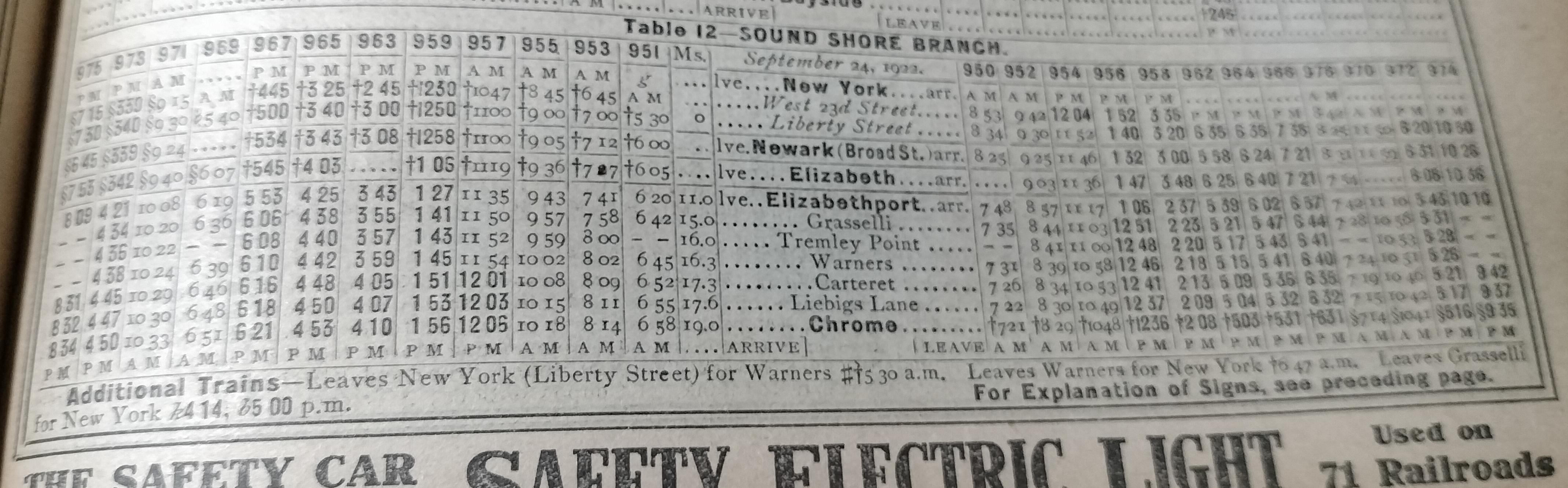
And let's go back to the March 1923 (!) Official Guide of the Railways for this timetable. Sorry that the image is a little wavy... I don't dare do anything to stress a book that wasn't meant to last more than a couple of years., which is now over 100 years old. (And in better shape than the ones I have from the 1940s and 1950s.)
George in Rochester NY
The Unofficial Micro-Trains Release Report (among other things)
The Unofficial Micro-Trains Release Report (among other things)