by Sand Box John
From Dulles Corridor Metrorail Project progress update e-mail 05 12 2010.
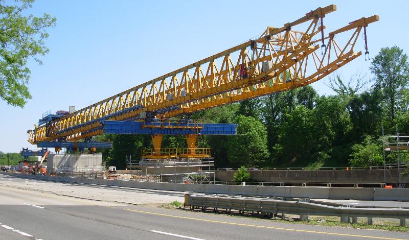
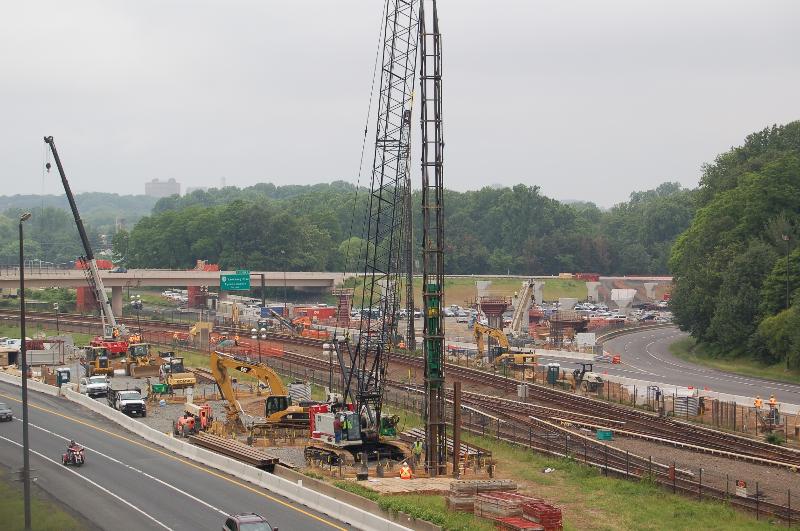
Truss erection at the Dulles Connector Road (Route 267) and Chain Bridge Road overpass.
Photo by Stephen Barna, Dulles Corridor Metrorail Project
Building Bridges for Rails in Tysons Corner
Aerial Superstructure Construction Begins
Construction will begin soon on what can best be described as "bridges" over Tysons.
One will begin this month on the Dulles Connector Road (Route 267) and cross over Route 123 to the northwest side of southbound Route 123. Another will cross I-495. Another will be built in the median of Route 7 from just west of Route 123 and into the median of the Dulles Airport Access Highway and the Dulles Toll Road.
These bridges are really guideways, or aerial foundations, to carry the tracks for the Dulles Corridor Metrorail Project.
Construction of the new rail line, an extension of existing Metrorail service from East Falls Church to Dulles Airport and eastern Loudoun County, is being built in two phases. Phase 1 work is well under way from I-66 to Wiehle Avenue in Reston. Four stations will serve Tysons Corner.
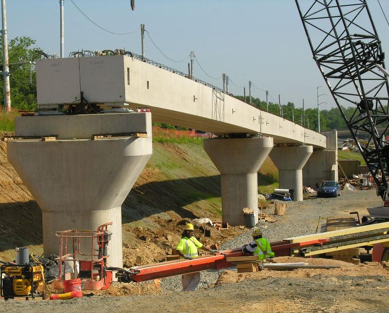
The first of those 366-ton trusses is now visible near the Dulles Connector Road and Route 123 where construction of piers that will support the aerial guideways have been built in recent months. Soon it will be used to build the spans of the aerial guideway between those piers. In a few months, other trusses will be assembled to erect guideways that cross I-495 and in the middle of Route 7.
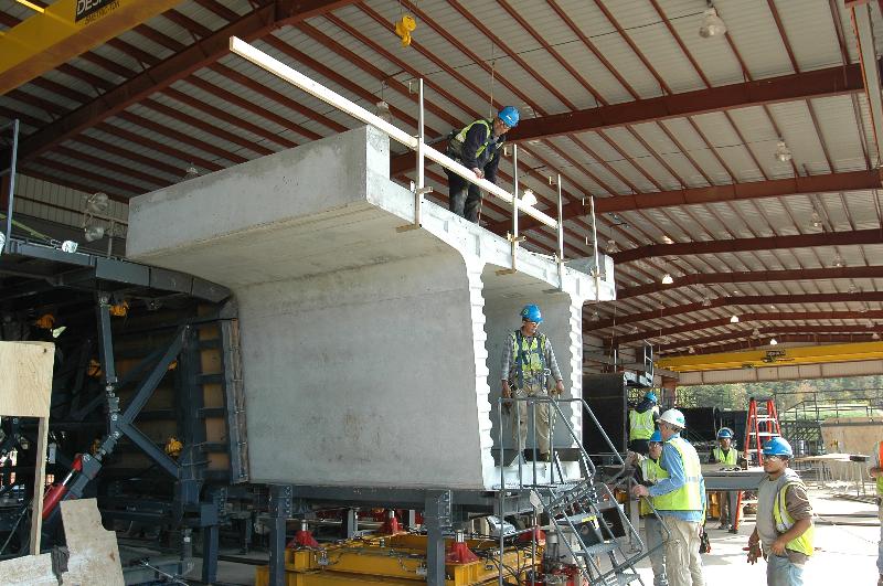
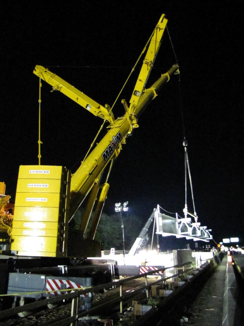
Segments are manufactured off-site at a precast facility near Dulles Airport.
Photo by Dulles Corridor Metrorail Project
Here is a guide to the erection of the spans in Tysons Corner:
Q. What is a guideway?
A. A guideway is a structure that supports trains or other vehicles that ride over it. This project features both at-grade and aerial guideways.
Q. How many miles of this project are aerial guideway?
A. Of the entire Phase 1 alignment of 11.7 miles, three miles of inbound and outbound guideway will be aerial - or a total of six miles of aerial track.
Q. What is the average height of the guideway (from ground level to the base of the guideway)?
A. The average above-ground height is 35.7 feet.
Q. What is the tallest point of the guideway?
A. Approximately 55 feet above the southbound entrance from Route 123 to I-495.
Q. Where will aerial guideway be built?
A. Aerial guideway begins where the new line splits off from the existing WMATA Orange Line tracks just before the West Falls Church Metrorail Station and yard. It will fly over the westbound lanes of I-66 and descend to the median of the Dulles Connector Road (Route 267).
Aerial guideway resumes at the Connector Road near the Chain Bridge Road overpass, then crosses over the eastbound lanes of the Connector Road onto the northwest side of Route 123, and into the Tysons East Station. The rail will continue at elevated level, flying over I-495 and into the Tysons Central 123 Station where the rail line briefly goes underground.
The tunnel portion resurfaces in the median of Route 7, at the Tysons Central 7 Station. From there, the rail line goes aerial again along the median of Route 7 to the Dulles Toll Road. One more flyover takes the guideway westward from Route 7, and the guideway then begins its descent to the median of the Dulles International Airport Access Highway, reaching ground level well before Wolf Trap National Park for the Performing Arts.
Q. How will the aerial structure be built?
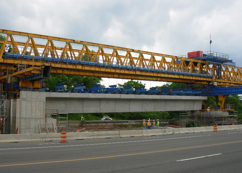
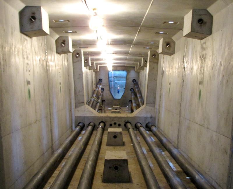
A. The guideway will be constructed by connecting more than 2,700 concrete segments, each weighing about 25 to 40 tons, using massive pieces of equipment called trusses. A truss is also known as a lifting gantry.
Q. What is a truss? How much do they weigh? How big are they?
A. A truss, or launching gantry, is a large, rigid structure that will erect and piece together the segments of the aerial guideway. The first truss that will be used has a total weight (structure and supports) of 366 tons.
Q. How many different trusses will be needed for this project?
A. Three.
Q. How and where are they being assembled? How will they be moved along the alignment?
A. Trusses are self-propelling mechanisms that erect spans between each pier. They will be assembled at the locations where the segment erection will begin.
Q. What is a segment? How big are they?
A. A "segment" is a large, unique piece of reinforced precast concrete designed to interlock with other segments to form a "span" between two piers. The segments are held together with steel cables, called post-tensioning strands. Spans make up the guideway.
Q. Where are the segments being made? How many are needed; what is the process?
A. The segments are all being fabricated off-site at a precast facility located in a remote area of Dulles Airport. More than 2,700 segments will be constructed and trucked to sites along the alignment. Each segment is custom engineered to fit a specific location along the alignment.
The casting plant is located on the site of the future Dulles Yard. The future Dulles Yard will be located in the 44300 block of Old Ox Road in Sterling, Virginia.
Q. How are they connected?
A. The truss' lifting mechanisms hoist the segments into place in the alignment, where they are sealed with epoxy, joined and aligned. The spans have steel tendons (post-tensioning strands) running through the interior of each segment that "string" the segments together into place.
Q. How big are the piers that will support the guideway?
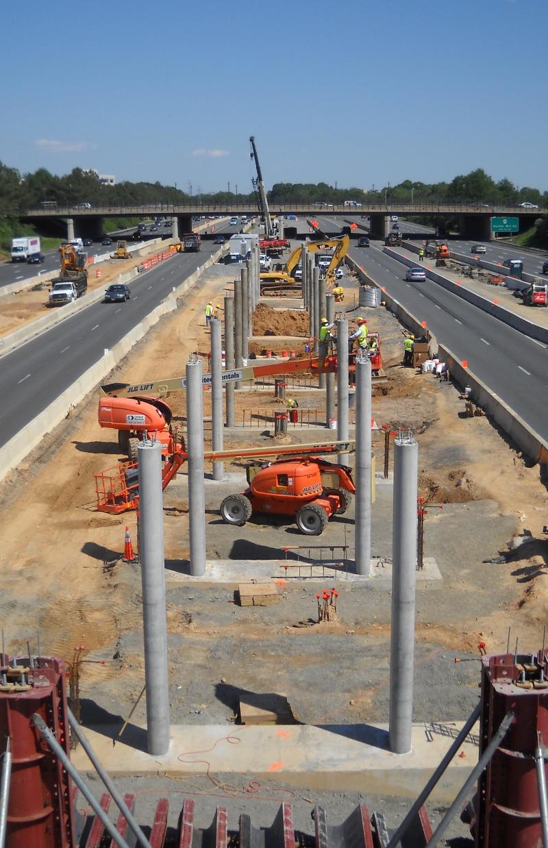
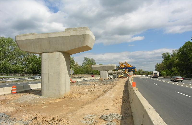
A. Piers vary in height; most piers are 6'x7', 7'x7' or 7'x9' rectangular columns.
Q. Who is the subcontractor? Describe their experience building guideways for other transit systems.
A. Rizzani de Eccher, headquartered in Italy, is the subcontractor that is fabricating the precast segments. The aerial team consists of leadership from Dulles Transit Partners (design/build contractor) and Rizzani's U.S. division. This team brings a combined experience of 50-plus years working on worldwide aerial and bridge projects.
Q. Will the work be done at night or during daylight hours?
A. For safety reasons, most of the work will be done during daylight hours, but some work may have to take place at night.
Q. The aerial guideway is being built in a densely populated area where cars and pedestrians are constantly present. What happens when construction is above roads and sidewalks? Will it be safe for cars and pedestrians? What are the safety procedures?
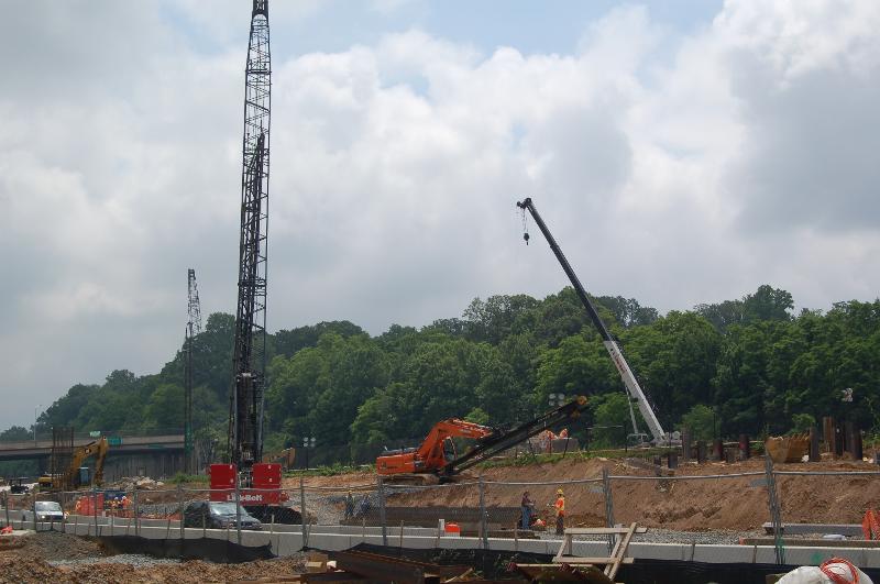
A. Traffic will be stopped momentarily when the truss moves over a roadway in between piers, and when the truss lifts segments from a truck onto its portion of the alignment. In some cases, to ensure everyone's safety, support work will require overnight closures of some main roadways. Contractors must adhere to a formal and extensive safety program while executing this work.
Q. When does the first work begin and where?
A. Construction of caissons, piers and pier caps to support the aerial guideway have been under way for several months and are very visible in the median of the Dulles Connector Road. The superstructure will begin at the Tysons East guideway, at the Dulles Connector Road and Route 123 and move across I-495. Expected completion: Late 2011.
Q. What is the schedule for Route 7 guideway construction?
A. Once the road shift on Route 7 occurs this summer, drilling of caissons (the underground foundations for piers that support the guideway) will follow. Expected completion: Mid-2011.
Q. Cost of the aerial guideway construction?
A. $170 million.
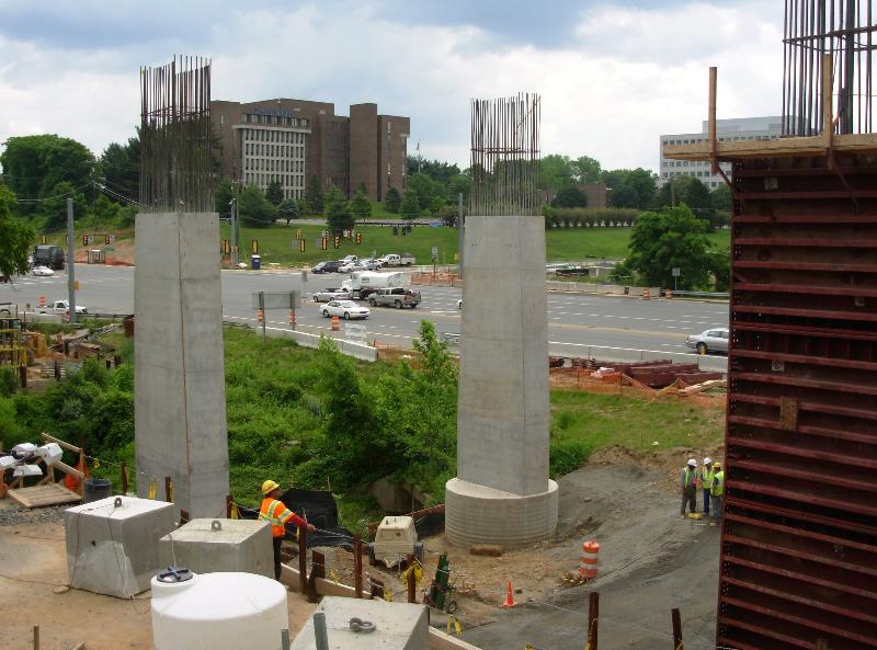
Piers on the Dulles Connector Road. The truss will connect the piers with the aerial guideway.
Photo by Dulles Corridor Metrorail Project
###
PDF version click here (268 KB)
Truss erection at the Dulles Connector Road (Route 267) and Chain Bridge Road overpass.
Photo by Stephen Barna, Dulles Corridor Metrorail Project
Building Bridges for Rails in Tysons Corner
Aerial Superstructure Construction Begins
Construction will begin soon on what can best be described as "bridges" over Tysons.
One will begin this month on the Dulles Connector Road (Route 267) and cross over Route 123 to the northwest side of southbound Route 123. Another will cross I-495. Another will be built in the median of Route 7 from just west of Route 123 and into the median of the Dulles Airport Access Highway and the Dulles Toll Road.
These bridges are really guideways, or aerial foundations, to carry the tracks for the Dulles Corridor Metrorail Project.
Construction of the new rail line, an extension of existing Metrorail service from East Falls Church to Dulles Airport and eastern Loudoun County, is being built in two phases. Phase 1 work is well under way from I-66 to Wiehle Avenue in Reston. Four stations will serve Tysons Corner.
The first of those 366-ton trusses is now visible near the Dulles Connector Road and Route 123 where construction of piers that will support the aerial guideways have been built in recent months. Soon it will be used to build the spans of the aerial guideway between those piers. In a few months, other trusses will be assembled to erect guideways that cross I-495 and in the middle of Route 7.
Segments are manufactured off-site at a precast facility near Dulles Airport.
Photo by Dulles Corridor Metrorail Project
Here is a guide to the erection of the spans in Tysons Corner:
Q. What is a guideway?
A. A guideway is a structure that supports trains or other vehicles that ride over it. This project features both at-grade and aerial guideways.
Q. How many miles of this project are aerial guideway?
A. Of the entire Phase 1 alignment of 11.7 miles, three miles of inbound and outbound guideway will be aerial - or a total of six miles of aerial track.
Q. What is the average height of the guideway (from ground level to the base of the guideway)?
A. The average above-ground height is 35.7 feet.
Q. What is the tallest point of the guideway?
A. Approximately 55 feet above the southbound entrance from Route 123 to I-495.
Q. Where will aerial guideway be built?
A. Aerial guideway begins where the new line splits off from the existing WMATA Orange Line tracks just before the West Falls Church Metrorail Station and yard. It will fly over the westbound lanes of I-66 and descend to the median of the Dulles Connector Road (Route 267).
Aerial guideway resumes at the Connector Road near the Chain Bridge Road overpass, then crosses over the eastbound lanes of the Connector Road onto the northwest side of Route 123, and into the Tysons East Station. The rail will continue at elevated level, flying over I-495 and into the Tysons Central 123 Station where the rail line briefly goes underground.
The tunnel portion resurfaces in the median of Route 7, at the Tysons Central 7 Station. From there, the rail line goes aerial again along the median of Route 7 to the Dulles Toll Road. One more flyover takes the guideway westward from Route 7, and the guideway then begins its descent to the median of the Dulles International Airport Access Highway, reaching ground level well before Wolf Trap National Park for the Performing Arts.
Q. How will the aerial structure be built?
A. The guideway will be constructed by connecting more than 2,700 concrete segments, each weighing about 25 to 40 tons, using massive pieces of equipment called trusses. A truss is also known as a lifting gantry.
Q. What is a truss? How much do they weigh? How big are they?
A. A truss, or launching gantry, is a large, rigid structure that will erect and piece together the segments of the aerial guideway. The first truss that will be used has a total weight (structure and supports) of 366 tons.
Q. How many different trusses will be needed for this project?
A. Three.
Q. How and where are they being assembled? How will they be moved along the alignment?
A. Trusses are self-propelling mechanisms that erect spans between each pier. They will be assembled at the locations where the segment erection will begin.
Q. What is a segment? How big are they?
A. A "segment" is a large, unique piece of reinforced precast concrete designed to interlock with other segments to form a "span" between two piers. The segments are held together with steel cables, called post-tensioning strands. Spans make up the guideway.
Q. Where are the segments being made? How many are needed; what is the process?
A. The segments are all being fabricated off-site at a precast facility located in a remote area of Dulles Airport. More than 2,700 segments will be constructed and trucked to sites along the alignment. Each segment is custom engineered to fit a specific location along the alignment.
The casting plant is located on the site of the future Dulles Yard. The future Dulles Yard will be located in the 44300 block of Old Ox Road in Sterling, Virginia.
Q. How are they connected?
A. The truss' lifting mechanisms hoist the segments into place in the alignment, where they are sealed with epoxy, joined and aligned. The spans have steel tendons (post-tensioning strands) running through the interior of each segment that "string" the segments together into place.
Q. How big are the piers that will support the guideway?
A. Piers vary in height; most piers are 6'x7', 7'x7' or 7'x9' rectangular columns.
Q. Who is the subcontractor? Describe their experience building guideways for other transit systems.
A. Rizzani de Eccher, headquartered in Italy, is the subcontractor that is fabricating the precast segments. The aerial team consists of leadership from Dulles Transit Partners (design/build contractor) and Rizzani's U.S. division. This team brings a combined experience of 50-plus years working on worldwide aerial and bridge projects.
Q. Will the work be done at night or during daylight hours?
A. For safety reasons, most of the work will be done during daylight hours, but some work may have to take place at night.
Q. The aerial guideway is being built in a densely populated area where cars and pedestrians are constantly present. What happens when construction is above roads and sidewalks? Will it be safe for cars and pedestrians? What are the safety procedures?
A. Traffic will be stopped momentarily when the truss moves over a roadway in between piers, and when the truss lifts segments from a truck onto its portion of the alignment. In some cases, to ensure everyone's safety, support work will require overnight closures of some main roadways. Contractors must adhere to a formal and extensive safety program while executing this work.
Q. When does the first work begin and where?
A. Construction of caissons, piers and pier caps to support the aerial guideway have been under way for several months and are very visible in the median of the Dulles Connector Road. The superstructure will begin at the Tysons East guideway, at the Dulles Connector Road and Route 123 and move across I-495. Expected completion: Late 2011.
Q. What is the schedule for Route 7 guideway construction?
A. Once the road shift on Route 7 occurs this summer, drilling of caissons (the underground foundations for piers that support the guideway) will follow. Expected completion: Mid-2011.
Q. Cost of the aerial guideway construction?
A. $170 million.
Piers on the Dulles Connector Road. The truss will connect the piers with the aerial guideway.
Photo by Dulles Corridor Metrorail Project
###
PDF version click here (268 KB)
Last edited by Sand Box John on Fri May 14, 2010 9:26 am, edited 1 time in total.
John in the sand box of Maryland's eastern shore.