Discussion of the past and present operations of the Long Island Rail Road.

Moderator: Liquidcamphor

SG

  by alcoc420
 
I see from a 1963 timetable there was a place called SG on the Main Line. Apparently, it was a passing siding west of Brentwood. Does anyone have any info on this in terms, was it on the north or south side, how long was it or where were the switches, what kind of signals protected it, etc. Thanks again.

  by bat@grumman
 
It's SG Cabin. See http://www.lirrhistory.com/cal22003.html for a list of all the old LIRR towers, etc. -pat

  by badneighbor
 
SG being Sagtikos

  by Dave Keller
 
NO . . . sorry . . . !

SG did NOT stand for Sagtikos, although it's a good guess!

Years before Sagikos ever existed, and before Brentwood station, there was a station at the location of where Sagtikos crosses the LIRR. A farm house/store was trackside and it served as a stop on the LIRR. LIRR timetables called it Thompson's, named after a family that owned most of the land there.

A long, passing siding was located there and it was called Thomspon's Siding. "SG" came from Thompson's "S"idin"G." The siding was south of the main. The calls "SG" were in use long before anyone ever heard or dreamt of the Sagtikos Parkway!

In later years (1920s to 1966) the siding was controlled by a block operator at a little wooden block cabin called"SG." The cabin was placed in service on the north side of the tracks and west of 2nd Street in 1916. The cabin was relocated to the east end of Pineaire siding (formerly Thomspon's Siding) on the north side of the main track and place in service on 6/11/44. The old cabin was taken out of service on 10/4/66, when it was replaced by a concrete block and brick cabin 2,292' west of the old cabin on the north side of the tracks and west of Fifth Ave. the block operator still manually threw the switch for the siding there. Both the siding and the cabin were placed out of service with the electrification project and double tracking through the area.

Here's the old cabin looking east towards Brentwood station c. 1925:
Image

And the replacement cabin looking west towards "SG" block signal:
Image

And my friend, the late George DiPiazzy, former block operator at "SG" manually throwing the switch to the passing siding:
Image

Dave

  by RetiredLIRRConductor
 
I believe SG was also a Block-Limit station when the Block station was Closed. If we had a meet there the train crews would throw the switches. I could be wrong but I seem to remember that.

  by badneighbor
 
OK...the SidinG story is good, and may very well be accurate. But the area where the siding was built led to the Thompson estate, and to the Gardiner Estate. They were basically the same area. I quote NYC Roads

REMEMBERING THE GARDINERS: The underpass carrying the northbound Sagtikos State Parkway underneath the westbound Southern State Parkway bears the following plaque from the LISPC, which built the underpass during the early 1960's:

"In memory of David Gardiner, from Sarah Diodati Gardiner and Robert David Lion Gardiner."

The Gardiners were the first non-native landowners in Suffolk County. In 1639, Lion Gardiner purchased Gardiner's Island (off the coast of East Hampton) from Native Americans, and founded the first English colony in present-day New York (it was part of Connecticut at the time). In 1758, the Gardiner family purchased a 1,200-acre estate in Bay Shore from Stephanus Van Cortlandt, the first native-born mayor of New York City. The estate had a manor house (built in 1692) called "Sagtikos Manor," which was named after a local Indian word meaning "snake that hisses."

The Gardiners disposed of much of the land before the Sagtikos State Parkway was planned, and sold Sagtikos Manor to Suffolk County in 1971. The last heir to bear the name of the Gardiners (and the "16th Lord of the Manor"), Robert David Lion Gardiner, died in 2004 at the age of 93.

Here is the link on the history of the Saktikos Parkway...

http://www.nycroads.com/roads/sagtikos/[url]

I think that both explanations have validity... I know Mr Keller has all the insiders info, I'm sure his story will be correct, but my case isn't bad...

  by Dave Keller
 
Yes, your case does have validity.

However, I've heard the "SG" for Thomspon's Siding from just about every old-time LIRR veteran for years including Bob Emery's research.

And I'm talking veterans who started LIRR service in the late 1890s.

Perhaps it's not correct and perhaps SG originally stood for Sagtikos due to the land grant however it is not the accepted story and I kind of find it hard to believe that ALL those people who lived during that era and worked with veterans older than them who would have started LIRR service in the 1860s and 1870s would have gotten it wrong. (AND the Thompson family owned the land when the LIRR when thru there in the 1840s as "Thompson's" as a stop appeared on the early LIRR timetables!!!)

This is why it's so important to keep the history alive. When one or two generations die off and data is not recorded, word-of-mouth, too, dies off and no one ever remembers the reason why or where or "how come?"

Preserve the Past!!!

Dave

  by badneighbor
 
i hear ya... i rest my case...

  by Dave Keller
 
LIRR Conductor:

I believe you're correct.

"SG" was not open 3 tricks, only 2, so you would have had to handle the switches (either end) yourselves at those times.

Dave

P.S. Looking at my older shot of the wooden "SG" cabin when it was west of 2nd Street, Brentwood, you can see the siding extended a lot further east at that time! It was a 40 car passing siding, that started at about MP40 and extended east, stubbing out on the west side of 2nd Street, to service Brentwood Lumber Co. A crossover was located on the east side of 5th Avenue and slightly east of the cabin (visible in my shot). The siding was extended further west to just east of Pineaire in 1948. When "SG" was moved as mentioned previously, to west of 5th Avenue, the siding was cut back to where it is shown in my shot of the block and brick "SG" cabin. DK

  by badneighbor
 
i know i'm beating a dead horse... what are the odds that a cabin was named SG for 'siding' in that particular spot? with all the very many signal structures on the whole system, it seems like some coincidence. I guess we won't know, those who named it in the days of steam and horse are long asleep these days. if the research says siding, the books must spell it out. In the day there must have been absolutely nothing there but scrub pines

  by Dave Keller
 
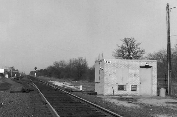
It's possible the "SG" was from "Thomp"S"on's Sidin"G" and not "S"idin"G". Who knows any more?????

As for naming it after a siding:

Why the following?

FY for Freeport
GD for Glen Cove, Glen Street (1903)
GW for Glendale
GY for Greenport
HN for Hicksville prior to "DIVIDE"
KF for King's Highway
MY for Montauk
ND for Far Rockaway (1878 Bk of Rules)
RI for Wantagh (1903)

and on, and on, and on . . . . . Pretty unusual combinations, and perhaps reaching in some cases. Had to be a reason, but, as you said, those that named these places are long gone. Who knows where they got their calls from. Could have been a local creek nearby, or a popular business trackside at the time and the initials stuck, or a nickname for an area that EVERYONE knew at the time but fell out of use as years passed, but, the railroad being the non-conforming company it was, retained the calls of the old name . . . . .(like "F" at Mastic for "Forge"!)

And who knows . . . .maybe "SG" WAS named for the Sagtikos land grant. But, unless the fact can be confirmed through another source, we have to go with what is (or was) common knowledge at the time.

If you find anything confirming your theory in your research, PLEASE let me know and perhaps we can rewrite the "history books!" Look what Columbus accomplished! :-D

Thanks for your insight!!!

Dave

  by Dave Keller
 
And here's a conflict . . . . .

Vincent Seyfried, eminent historian, says in his LIRR history that Thompson's Station was located where today's Sagtikos Parkway crosses the LIRR (later Pineaire).

Bob Emery, noted LIRR fan and historian in his own right, indicates Thompson's Station on his maps at the northwest quadrant of the crossing of 5th Avenue and the LIRR tracks in Brentwood.

Who's correct?

As Thompson's WAS the previous name for Brentwood, I kind of have to think that Emery is more correct. Also, Thompson's Station was no longer needed once Suffolk Station was built there around 1878 and Thompson's was dropped from the timetables. When Suffolk Station was moved further east and renamed Central Islip, there was again a need for a station to service the Brentwood area and Brentwood became a stop.

Also, "SG" cabin was originally located west of 2nd St. in Brentwood and the siding extended from 2nd St. to MP40. Quite a distance from the latter-day Sagtikos Parkway area.

How far east did the Sagtikos land grant extend? Into the environs of Brentwood?

Dave

  by RetiredLIRRConductor
 
Don't forget "LD" In riverhead, to honor Larry Dixon. former (now deseased) Superintendent of Transportaion/

  by UN Block
 
I once heard that the letter "Y", when in the second place of a call letter, stood for "yard." Also seems plausible, no?

  by Dave Keller
 
LIRR Conductor:

Thanks for the clarification.

I've been wondering for years what "LD" stood for!

Dave :-D