• Red Line to Brockton?

  • Discussion relating to commuter rail, light rail, and subway operations of the MBTA.
Discussion relating to commuter rail, light rail, and subway operations of the MBTA.

Moderators: sery2831, CRail

  by cpontani
 
The only way the Red Line will ever get NEAR Lexington is if it's tunnelled underneath en route to Hanscom, and, most importantly, with no stops. Any original ideas to use the B&M ROW at grade through Lexington has exaxtly 0% from happening. Then again, look what happened in Hingham.

But trying to get back on topic, most of the heavy rail T expansions could happen along existing commuter rail ROW's, i.e. Orange Line to 128 or Needham. At this point, does demand warrant upgrading to subway service? Can more frequent commuter rail service better serve the demand with MUCH lower cost. Insufficient parking and rebuilding stations to turnstile service will be cost-prohibitive.
  by Gerry6309
 
Someone suggested a Terminal at South Station in the area of the existing Post Office property. That would add up to a terminal, and not much more. There are virtually no routings possible without crossing the Federal Reserve Bank property, a very unlikely proposition. The only way to do it would be a deep level tunnel below the existing Red Line with an S curve reminiscent of the curve at Harvard. The tunnel would have to run downgrade to two levels below the Red Line and then curve sharply north underAtlantic Av. That would put it over 100 feet down beneath both the Silver Line and the northbound lanes of I-93. A better routing would be under Atlantic Av. at deep level all the way from the Cabot area or under the southbound artery. No matter how you do it, it will be $$$expensive$$$!
  by Charliemta
 
A route as marked on this aerial photo would enable the new line to go over the existing Red Line tunnel:

Image
  by F-line to Dudley via Park
 
Charliemta wrote:A route as marked on this aerial photo would enable the new line to go over the existing Red Line tunnel:

Image
That's exactly the preferred alignment for the N-S Link: hug Dot Ave. from the yards and over the demolished postal property to integration into the side of SS proper, continue up Dot Ave. across Summer and start on a gentler swooping curve under the channel until merging with the Artery-cleared ROW when that turns due north between Seaport Blvd. and the Northern Ave. bridge. The building pilings in the SS area don't allow it to go straight through the gut of SS a block inland, anyway...so this is the recommended alignment by whatever the last official engineering study was earlier this decade.

Still getting ahead of ourselves. I'm fine with a simple stub-end terminal underground on the Dot Ave. side for the Indigo. Doesn't even have to cross Summer. Just stop it with basement access and keep the ROW angled on the Dot Ave. alignment for future-proofing. That's all. Any new buildings on top of the demolished postal facility will be required to be designed to accomodate this ROW because it's the only feasible routing for the N-S link that doesn't involve razing a whole block-and-a-half of office and gov't buildings and twisting the tunnels like a pretzel. The postal facility itself is currently almost as wide as SS and all the platforms, so when the parcel gets redeveloped on the Dot Ave./channel-facing side SS is going to reclaim almost half the space for immediate track expansion and general breathing room on its most cramped side. That was the idea on how redevelopment of the parcel could co-exist with all the N-S ROW provisions that have to be provisioned for before any new structures get their foundations poured.
  by Gerry6309
 
You would have to build a cofferdam to get over both the Red and Silverlines where they get under the channel. Then there is the question of the granite wall along the channel.

Perhaps this thread should be renamed "Red Line to Brockton, Elsewhere?"
  by F-line to Dudley via Park
 
Gerry6309 wrote:You would have to build a cofferdam to get over both the Red and Silverlines where they get under the channel. Then there is the question of the granite wall along the channel.
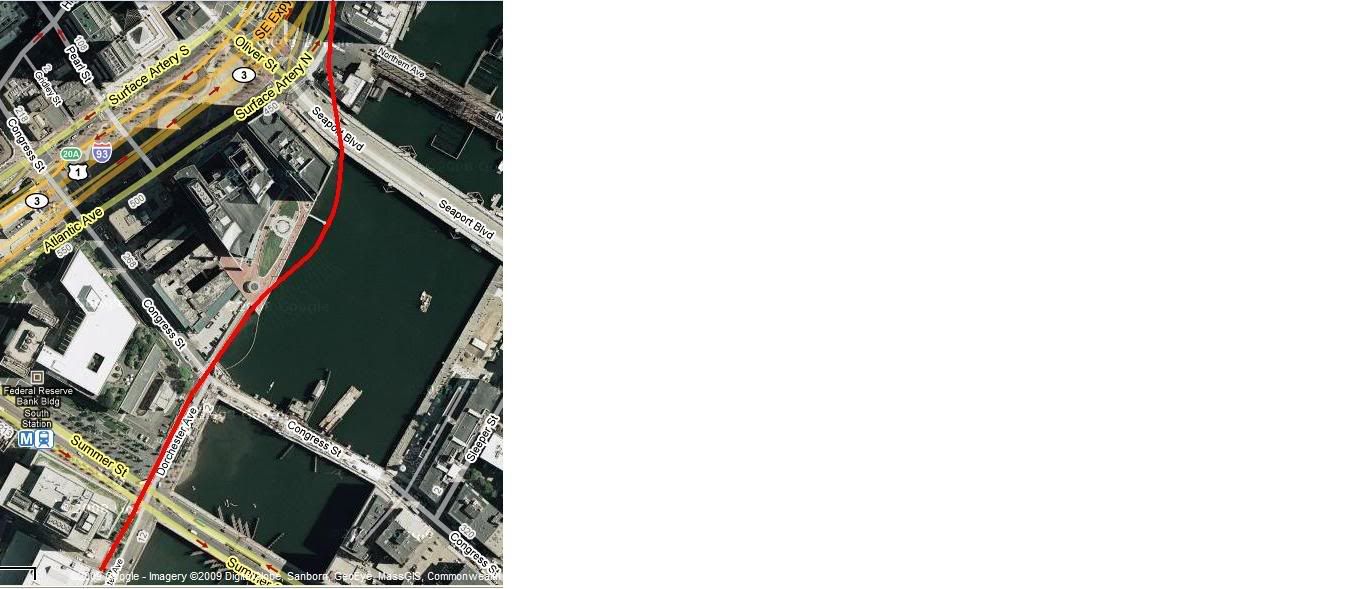
Don't know, but the one eng. survey summary I Googled last night did have that exact Dot Ave. / underwater swoop as "the" preferred alignment for N-S since a through-the-gut ROW would chew up too high a percentage of project costs to negotiate all the buildings and underground infrastructure. Unfortunately some of the old more detailed PDF's of the studies from several years ago have broken links now, but I know the possible alignments were specced out in a bit more detail somewhere. So the engineers do think there's a feasible route for a double-berth tunnel that would eventually go stacked bi-level under the artery after Seaport Blvd. when it merges back on that alignment. And that is why the postal redevelopment is reserving so much space for a wider SS property and why design of the TOD on top of it has to accommodate N-S guts underneath. Since the Feds would be all over funding of that project and the state obviously wants this to happen someday in the future, they're not going to let the T be the T and bollix up the ROW provision with some short-sighted solution that blocks the path. It probably would've had to be accounted for when the SL tunnel was built since this was originally supposed to be part of the Big Dig proper.

Of course it's not easy, but it is after all a projected $10B project at current estimates. I'd be happy with anything that gets the Fairmount rapid-transited economically and on reasonable time table--even a surface stub terminal on the postal property to the side of the existing CR berths--so long as it reserves space/footprint for and does not preclude a future genuine subway platform and continuing N-S ROW alignment. In fact, I'd fully expect that even a DMU'd Fairmount would be on a similar separate surface platform on that side, so as a starter for getting it done that's just peachy. I'd prefer the RL rolling stock over DMU's because you could maintain full grade separation from the CR and not choke capacity, use pre-existing RL yard space for the approach ROW, not even have to maintain a separate equipment mode (or separate equipment at all), and be able to alt-route northbound RL service express to SS to the same platform on unutilized pre-existing infrastructure without having to lay a single new piece of rail south of Cabot.
  by djlong
 
[quote="F-line to Dudley via Park
Of course it's not easy, but it is after all a projected $10B project at current estimates.
[/quote]

And I remember when, in the late 1980s, the estimare for it was $1B and that included central Station and electrifying existing commuter rail lines.