• Pilrim State Hospital - new webpage

  • Discussion of the past and present operations of the Long Island Rail Road.
Discussion of the past and present operations of the Long Island Rail Road.

Moderator: Liquidcamphor

  by nyandw
 
http://www.trainsarefun.com/lirr/pilgri ... mstate.htm
Image
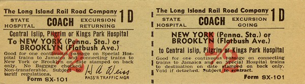
A "special excursion" ticket for the three (3) State Hospitals and not a regular issue. Normal fares for the train to Pilgrim State Hospital station were issued as "Brentwood" printed ticket stock. Archive: Richard Makse

Image
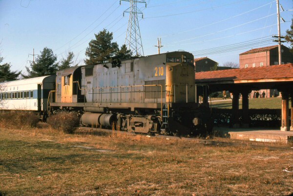
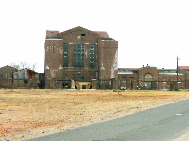
C420 #210 Pilgrim State Hospital Station Brentwood 12/28/1975 (Madden-Keller)
  by RestrictOnTheHanger
 
Is that on G road just past the sagtikos overpass? There's a small structure that looks oddly similar and buried in brush. Ironically I drive past that spot when I decide to go out of Deer Park.
  by nyandw
 
RestrictOnTheHanger wrote:Is that on G road just past the sagtikos overpass? There's a small structure that looks oddly similar and buried in brush. Ironically I drive past that spot when I decide to go out of Deer Park.
Not familiar with G Road, I'm here in Florida. Photo the spot and I/we can figure it out. Thanks. :-)
  by ErnieM
 
RestrictOnTheHanger wrote:Is that on G road just past the sagtikos overpass?
Bingo, that's exactly where the station shelter is.

If you make the next left just after that you come to the remains of the coal fired power plant. Around back is the trestle where the LIRR delivered coal.

Google or bing the area with overhead images and you'll see what I mean. The ROW ends near the main line but you can trace the scars it left behind.
  by RestrictOnTheHanger
 
That's it!

And I also drive past the old power plant and coal trestle, those were way more obvious.

Thanks guys.
  by RestrictOnTheHanger
 
nyandw wrote:
RestrictOnTheHanger wrote:That's it! And I also drive past the old power plant and coal trestle, those were way more obvious. Thanks guys.
Like this: Image
Exactly. No way to miss that.
  by Crabman1130
 
Which end of the trestle was connected to the spur?

The east end looks very close to the spur to have a gentle enough grade.
  by nyandw
 
Crabman1130 wrote:Which end of the trestle was connected to the spur? The east end looks very close to the spur to have a gentle enough grade.
I put a photo 3/25/2006 map tour up: http://www.trainsarefun.com/lirr/pilgri ... mstate.htm

The 1958 Emery map, I added photo locations numbers, illustrates the spur, coal trestle/power plant, station, etc.
  by ErnieM
 
The spur off the main line runs between Heartland park and the Sag, you can see it going up from just off center bottom. The coal trestle spur cuts off from that heading west across the cutoff road from back of the ADP center. You can see the trees following the old ROW.

Image
  by nyandw
 
nyandw wrote:
Crabman1130 wrote:Which end of the trestle was connected to the spur? The east end looks very close to the spur to have a gentle enough grade.

I put a photo 3/25/2006 map tour up: http://www.trainsarefun.com/lirr/pilgri ... mstate.htm The 1958 Emery map, I added photo locations numbers, illustrates the spur, coal trestle/power plant, station, etc.
Crabman1130: Did you find what you needed?
  by RestrictOnTheHanger
 
Nice pictures of the abandoned trestle on the site.
  by BobLI
 
Can any former employees give the ridership numbers on the hospital trains? Just how popular were they during the decades they ran?