• Old Garden City Freight yard

  • Discussion of the past and present operations of the Long Island Rail Road.
Discussion of the past and present operations of the Long Island Rail Road.

Moderator: Liquidcamphor

  by thrdkilr
 
Looking at the Circus thread and the outstanding pictures from Art's Archives of the old Garden City freight yard (prior to 1956), a couple of questions occured to me. Which way did they bring in the trains, main line or hempstead branch? Prior to 1956, what was the freight situation on the secondary? I remember as a wee one a lot of A&P trucks at the Garden City Freight yard, why would that be when they had the 3 or 4 sidings at their warehouse? Thanks guys....
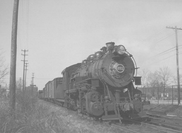
  by Dave Keller
 
Here's a shot c. 1946 where freight is coming in southbound from Mineola.

The substation is in the background:

Image

The west leg of the wye in Garden City was removed in 1950 and access to the branch was via the east leg, connection of which was reworked in 1959 and remained in service.

Dave

  by thrdkilr
 
As always Dave, thank-you....


"Power does corrupts, and absolute power corrupts absolutely"
Lord Acton

  by Long Island 7285
 
Dave, Great pic I necver seen that part of the branch in service, thats the first pic i seen of that strech of the branch.

Is the 250 useing a sloped tender?

  by Dave Keller
 
Yes. It's sloped.

Also notice the 3rd rail. It was placed in service in October, 1926 for thru passenger service between Valley Stream and Mineola.

Freight sidings were electrified during 1928-30.

I have numerous train orders issued at "MT" tower ("NASSAU") in 1929 for steam engines working freight along that spur as well as for MU trains in passenger service and MU work extras!

Quite busy at one time.

Dave

  by Long Island 7285
 
Speaking of the GC spur and GCS I found a google link with the switch i was talking about eairler over the meadowbrook.

http://maps.google.com/maps?f=q&hl=en&q ... 002658&t=h
Thats a sattle light map, to the "right" is east, Prior to that building, did that spur ever lead to the raceway it's self?

also the map shows a spur further west on the secondary, that curved north.

Click back to check HC, The diamond of the "Y" and crossing is still clearly vissible. follow it north and you will loose you self when the ROW actually "disapears" into modern developement :( some buildings but mostly parking.