Discussion related to commuter rail and rapid transit operations in the Chicago area including the South Shore Line, Metra Rail, and Chicago Transit Authority.

Moderators: metraRI, JamesT4

  by farecard
 
I'm flying into MDW and wondering how to get to the Fairmont. Google Transit has me walking to a 63W bus, to the Orange line, then a 10 minute walk from State/Lake. Any better suggestions from the experts here?
  by doepack
 
Midway airport is the terminus for both the Orange line and bus route 63W, so I would ignore Google's advice about catching this bus when you fly in. Assuming you're talking about the Fairmont hotel at 200 N. Columbus in downtown Chicago, just hit the Orange line from Midway, and get off at State/Lake. Walk east on Lake St. three blocks to Stetson Ave. (one block east of Michigan). Left on Stetson one block to South Water, right on South Water to Columbus, and right again about 1/2 block south, and you're there; the building will be on your right. I would agree with Google's guess about this being a 10-minute walk or so from the State/Lake 'L' station...
  by farecard
 
doepack wrote:Midway airport is the terminus for both the Orange line and bus route 63W, so I would ignore Google's advice about catching this bus when you fly in. Assuming you're talking about the Fairmont hotel at 200 N. Columbus in downtown Chicago, just hit the Orange line from Midway, and get off at State/Lake.
So where at Midway do I catch the Orange Line? I've looked at the Midway page, and gather only that it is the far end of the parking garage. How far a hoof is that? Is the distance why the 63W came up with Google?
  by EricL
 
It is a little bit of a hike, but it isn't awful. There are plenty of "Train to City - CTA" signs in the terminal and concourse to direct you. You go through an enclosed walkway passing through the parking garage, then down a flight of stairs, where you arrive at the bus bay + L station entrance.
  by Tadman
 
five minute walk - come out of the tunnel from the concourses, the baggage claim escalators are in front of you and so is a catwalk to the parking garage - follow that catwalk and the signs are continuous. it's really easy.
  by farecard
 
Thanks. The issue I now see is the various trip-planners give me a variety of routes & station names.

While I'm OK with that, I need to be sure the other folks won't get confused.

For example, goroo.com to "Fairmont Hotel" says take the Orange to Roosevelt, and the Green Line back to Randolph. But if I put in "200 North Columbus Drive" it starts talking about Upper and Lower.... huh?

GoogleTransit, linked by CTA, if you ignore the 63 bus, does say Orange Line to State/Lake.

But the Orange Line schedule page <http://www.goroo.com/goroo/getCtaRailSc ... tation.htm> talks about Midway->State, not State/Lake.
  by GWoodle
 
It is confusing. It may take 5 minutes to walk from the Midway gate to the Orange Line station. It appears the Almost to Midway walkway is still in operation. In good weather, it may be easier to walk south to 59th street then follow the curve back East to the station. This may be the bit where the 63W bus can avoid some walking. The bad news is you would have to buy a transfer on the bus to use the train.

There may be a debate between the State/Lake or Wabash/Randolph EL stations. The transfer to a Green Line train may be to take you north before turning west. The Orange Line may turn west before completing the loop to get back to S/L or W/R. It would be too much of a hassle to get a Red Line State Street Subway train. There may be another 15 minute walk to your hotel. There ought to be another bus working north on Michigan. The transfer you bought would still be good. Hope you don't have too much baggage to lug aboard the bus/train. This may be one time one of those wheeled plastic carts would be nice.
  by justalurker66
 
farecard wrote:For example, goroo.com to "Fairmont Hotel" says take the Orange to Roosevelt, and the Green Line back to Randolph. But if I put in "200 North Columbus Drive" it starts talking about Upper and Lower.... huh?
Columbus Drive is a multi-level road. There are actually three levels, the upper does not cross the river and runs from Wacker to Randolph St with the main entrances to the hotels. Columbus Drive is the middle level ... basically a through street that branches off from Lakeshore Drive from the south and crosses the river. Access to some hotel parking garages are on that level. Then the lowest level is below that with access to more parking garages, the busway and employee access to Metra/South Shore. All levels are pedestrian but there are some residents of the street on the lower levels despite the city's efforts to make that difficult.

It is a bit of a maze to drive until you're used to it but since you're not driving that shouldn't be a problem. The Upper/Lower levels extend along the riverfront to the Willis (Sears) Tower ... Lower Wacker is a favorite place to film action movie chases.
  by vxla
 
Here's a nice map of the three levels in the New Eastside.

Image
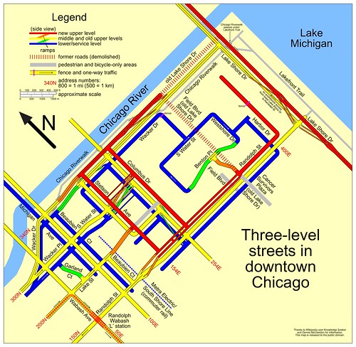
threelevelstreets by vxla, on Flickr

As for the OP's question: get off your plane, get your bags, and follow the signs to the Orange line and take it to Randolph/Wabash in the Loop.