Was there ever a south to east wye here, allowing direct running into the dock for loaded coal trains? The northern boundary of the housing tract to the south of the junction has a suggestive arc, which is clear on Google Earth.
Railroad Forums
Genesee Dock Junction, near Rochester NY?
- Discussion relating to the B&O up to it's 1972 merger into Chessie System. Visit the B&O Railroad Historical Society for more information. Also discussion of the C&O up to 1972. Visit the C&O Historical Society for more information. Also includes the WM up to 1972. Visit the WM Historical Society for more information.
I don't know, but the NY forum would be a far better place to ask this.
Check out my photography from around the Finger Lakes. [url] http://joshua-house.artistwebsites.com/ ... +state/all[url/]
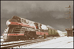
Photo by Richard Pearson, 1969, from Boxart Street in Rochester:
http://farm3.static.flickr.com/2119/254 ... 49d0_o.jpg
-otto-
http://farm3.static.flickr.com/2119/254 ... 49d0_o.jpg
-otto-
----------------------------------------------
Moderator: New York State Railfan :: New York Central :: Toy Trains
NYW&B Fan Site :: A Magazine I Read Often :: A Museum I Volunteer At
Moderator: New York State Railfan :: New York Central :: Toy Trains
NYW&B Fan Site :: A Magazine I Read Often :: A Museum I Volunteer At

I can give a little tour; I grew up a couple miles north of there. The northern-most point remaining of the B&O belt line is now at Stonewood Ave, where the Rochester & Southern serves a lumber company. (looking north)
http://i300.photobucket.com/albums/nn4/ ... 6-1975.jpg
In the last few years of Penn Central, I used to chase PC F7s and Alcos hauling coal empties south from Charlotte. I hiked south from Stonewood in 1974 to the junction to set up for a shot. The dock branch dispatcher's office was empty at the time, since he had left to pick up a lawn mower to clear the siding to the left of the picture (not). The trackage to picture's lower right heads for the dock. (looking north)
http://i300.photobucket.com/albums/nn4/ ... 8-1974.jpg
Some time later, F7s and GP9Bs slugged upgrade under the dock branch trestle.
http://i300.photobucket.com/albums/nn4/ ... 8-1974.jpg
My own shot of the dock in 1973, about a year before the trestle was torn down.
http://i300.photobucket.com/albums/nn4/ ... 2-1973.jpg
By 1978, most of the dock branch sidings were removed, as the community helped establish Turning Point Park. The rail bed is now mostly paved with asphalt for hiking and biking.
View of Ontario car ferry slip (looking east from parking/overlook area at end of Boxart St)
http://i300.photobucket.com/albums/nn4/ ... -1978a.jpg
Some trestle footings and a view of the embankment where the previous shot was taken from (looking northwest)
http://i300.photobucket.com/albums/nn4/ ... 0-1978.jpg
There was one siding remaining by late 1978, with a switch, even - to left of photo. The return track from the lower level connected to the south of this location (looking south)
http://i300.photobucket.com/albums/nn4/ ... 0-1978.jpg
I collected a series of articles in the Greece Post by Bill Aeberli on the Buffalo, Rochester, & Pittsburgh, some of which illustrated the Ontario car ferries (1&2) and dock operations. I think the articles appeared in the early 1970s.
Great photos, thanks for sharing!
-=otto-
-=otto-
----------------------------------------------
Moderator: New York State Railfan :: New York Central :: Toy Trains
NYW&B Fan Site :: A Magazine I Read Often :: A Museum I Volunteer At
Moderator: New York State Railfan :: New York Central :: Toy Trains
NYW&B Fan Site :: A Magazine I Read Often :: A Museum I Volunteer At
You can find one of the concrete shanties where the south end of the Dock Branch yard met the return track from down below (I don't know the B&O's terminology for trackage here):
http://www.rrpicturearchives.net/editPi ... id=1397860
Return track/main track junction point, paved for Turning Point Park:
http://www.rrpicturearchives.net/editPi ... id=1397861
Return track at bottom of the hill:
http://www.rrpicturearchives.net/editPi ... id=1397863
Photos were taken on the Rochester River Romance weekend, October 2008. Turning Point is a nice park to walk or bike, with a canoe launch north of the Ontario ferry slip. Looks like the Canadian concrete delivery continues at a dock.
Here is some more info about Genesee Docks:
http://gold.mylargescale.com/Scottychao ... Docks.html
thanks,
Scot
http://gold.mylargescale.com/Scottychao ... Docks.html
thanks,
Scot
~ Scot Lawrence
Moderator: Lehigh Valley
Co-Moderator: Anthracite Railroads
Scot's railroad webpages
Moderator: Lehigh Valley
Co-Moderator: Anthracite Railroads
Scot's railroad webpages
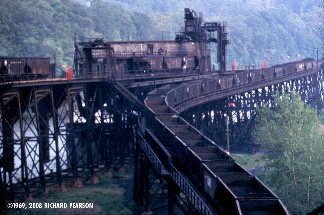
The point where the track split to begin the descent to the river level was known as Feldspar Junction. In the middle of the three photos, the view is essentially north. To the left was the Dock Yard (tracks 1-6), to the right the track dropped to access Genesee Dock, and the empty trestle of Charlotte Dock.
I can recall a day very late in the season with lake effect snow. The crew was shoving empties up that hill and just barely moving - at first glance the caboose would appear to be stationary. It took quite a while until they reached more level and were able to pick up speed.
I can recall a day very late in the season with lake effect snow. The crew was shoving empties up that hill and just barely moving - at first glance the caboose would appear to be stationary. It took quite a while until they reached more level and were able to pick up speed.

RussNelson wrote:...A little bit off topic, but of historical interest and further south on the B&O: if you open the Acme mapper link and pan south to W.Ridge Rd, you can see a B&O connection to Kodak Park that used to cross at Bldg 28 or whatever it's called now. There were a couple sidings for some business at the Dewey Ave crossing, then the track made its way to the Park. You can see where the B&O cut west off its belt line and headed across two diamonds to get there. I love old maps... and "current" maps that show rail lines long since gone.
Current map viewer:
http://mapper.acme.com/?ll=43.22599,-77.62101&z=16&t=M
Sorry Bob, you're a bit confused there. What you are seeing is the Kodak Park Railroad. Those are not diamonds, it's an underpass going under both the NYC and B&O. And it's still there.
BR&P wrote:Sorry Bob, you're a bit confused there. What you are seeing is the Kodak Park Railroad. Those are not diamonds, it's an underpass going under both the NYC and B&O. And it's still there.Okay, I was confused, and read the map wrong. It doesn't show what I recall. The trackage I remember has been long ripped up and crossings paved over. I'm willing to bet it was a B&O connection they let go.
Having grown up in Greece, I remember a line running from Dewey Ave to Bldg 28 along Palm St. I don't think Kodak would have a line running outside the Park property for that connection. I vaguely recall a little-used crossing at Dewey and Palm St, as well as Ridge Rd at Bldg 28. My dad would take the family to travelogue shows at Bldg 28, so I remember seeing the street running connection at that intersection. I also vaguely recall seeing B&O power and maybe some coal hoppers around Dewey and Palm, which sort of makes sense with the coal-fired power plant in Kodak Park near Lake & Ridge. I also worked 2 or 3 summers in Kodak Park behind Bldg 28, so I saw rails buried in the pavement running to that gate every work day.
OK, you're a little less confused than I thought at first, but still not 100% right either 
What you are thinking of was an NYC line, not B&O. It was the original entrance to Kodak, and to the end of its existence was known as the "Old Way" (for some reason, it was always pronounced with the emphasis on the second word - "the old WAY")
This was accessed by a trailing point switch northbound off the Charlotte Branch, just south of the Kodak RR overpass. The line wound around through the side streets, crossed Dewey Ave just south of Steko Ave, crossed Palm Street, and entered Kodak by crossing Ridge Road as you say, by Bldg 28.
I'm not sure what date the present entrance to Kodak was created, but the Old Way remained in service until I believe the mid 1970s, just not as an entrance to Kodak. The line had numerous other customers and would have made a good modeling project, as it involved interesting switching moves.
At one time there was a receiver of stone for cemetery monuments, Kittleburger Furniture, Clark Steko Pastes, Crescent Puritan Laundry, Ring Fuel (coal dealer), Keystone Builders Supply, and I believe a couple others - all within slightly less than a mile.
When I went to school in the area in the early 60's, the tracks were still in from Palm Street to Kodak, but no longer were used. Somewhere about 1960 the curve was paved over, it became Pillaroscia's Parking, but the rails were still in. But the farthest they were used was to Keystone Builders at Palm Street. My regular route to school was walking down the tracks from Dewey Ave to Palm Street, inspecting whatever cars were there and sometimes climbing up and walking the roofwalks if there were no workers around unloading them.
There were 2 passing tracks across Ridge Road at the newer entrance (right next to the B&O). The west one was the passing track, the east one was known as the Old Way - in other words the track thus known started north of Ridge Road, went south along Kodak, then turned east and became the branch I've described.
So - you are mistaken about B&O going back there, but NYC very certainly did.