Railroad Forums 

  • Abandoned bridge in Bound Brook

  • Pertaining to all railroading subjects, past and present, in New Jersey
Pertaining to all railroading subjects, past and present, in New Jersey

Moderator: David

 #910983  by carajul
 
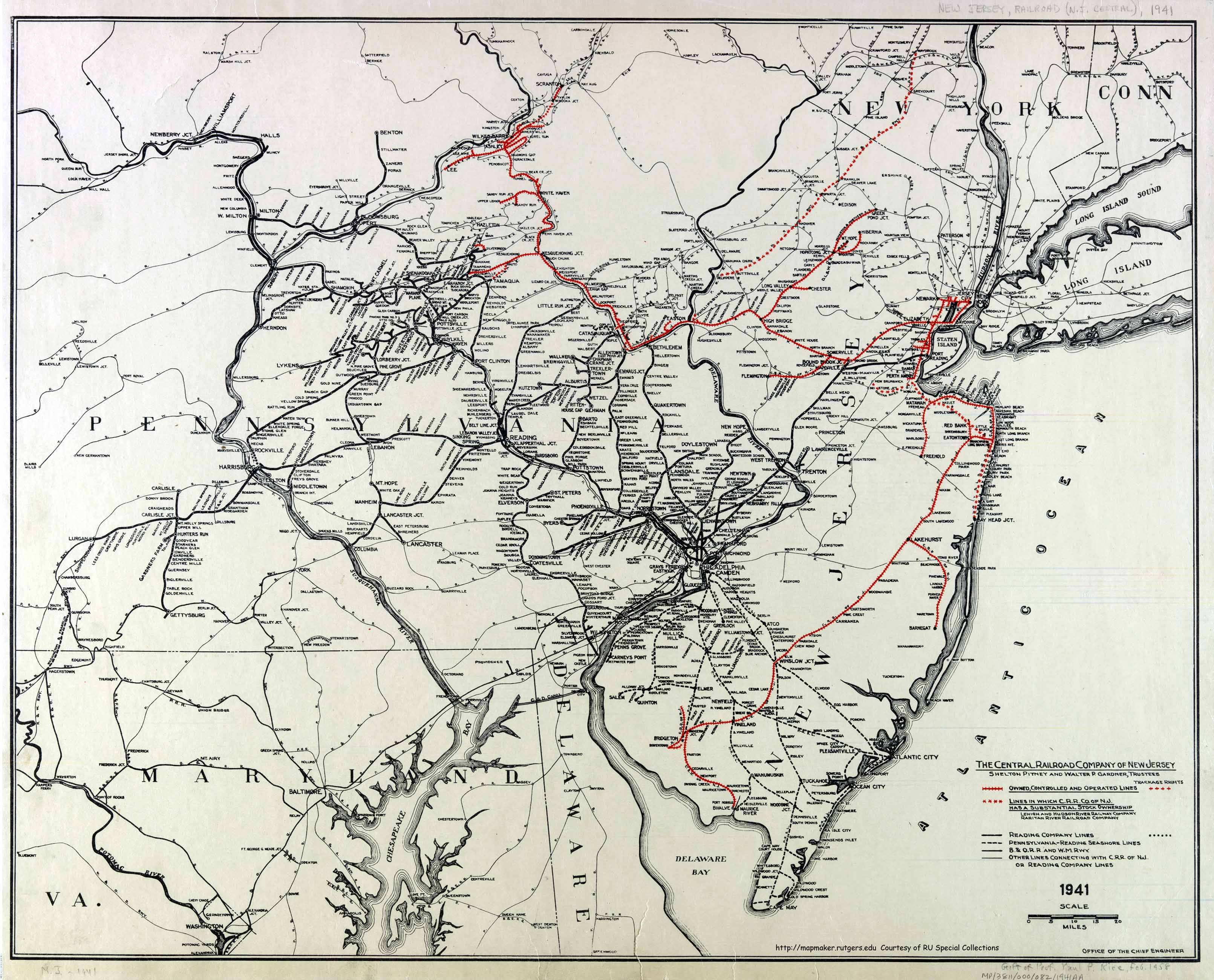
What was the spur that crossed the river just east of Bound Brook? It went over a bridge. The bridge is still there but no tracks for as long as I can remember. Must have been one heck of a customer for them to build a bridge like that just for a spur! A few million dollars I'd figure. Kinda odd to see it abandoned.

Oooops. My OP was from memory. I just checked live maps. The bridge is gone and and factory is now condos! There is a short part of the bridge over the cancal that's still there. It's now a hiking trail for the condo residents. But the big bridge over the Raritan is gone. Well any info would still be appreciated.

Yes the curved bridge off the Port Reading secondary.
Last edited by carajul on Tue Mar 15, 2011 6:00 pm, edited 2 times in total.
 #910985  by Kaback9
 
Out of curiosity, are you asking about the bridge that would of connected to what is today's Port Reading Secondary? It is kind of on a curve as it crosses the Raritan?
 #911271  by JimBoylan
 
There was a South Bound Brook branch of the Reading, which crossed the river on a long curved trestle to serve a roofing company. ConRail abandoned it around March of 1983.
McHugh Bros. Heavy Hauling, Operator & Leasee of the New Hope & Ivyland RR back then, was asked by the customer to try to buy the line, and the customer tried to make an Offer of Financial Assistance. NHIR suggested that the line wasn't worth as much as ConRail wanted, because so much of it was on the bridge. However, ConRail's selling high price was because they wanted to get rid of the business, because it was a low priced commodity and used boxcars.
 #911278  by Sir Ray
 
carajul wrote:I just checked live maps. The bridge is gone and and factory is now condos! There is a short part of the bridge over the cancal that's still there. It's now a hiking trail for the condo residents. But the big bridge over the Raritan is gone. Well any info would still be appreciated.
No help on the history of that bridge, but some Bing views still have it (others don't - and with the zoom feature, if you start farther out you see the bridge, but as you zoom in it disappears. I do remember seeing that bridge from the (S.) Main St. bridge and wondering what it was for, and I remember the townhouse complex going up at least 5-6 years ago - yes, Historic Aerials shows the Townhouse complex in 2006, but a large industrial complex in 2002 2002 Aerial - track looks gone by 2002, although the image quality is not too hot so I can't say for certain - go back to 1979 and you see a lot of industrial trackage, looks like a switchback w/ several spurs heading west off it.
Hmm, maybe this info helps (from wiki on South Bound Brook)
A roofing material manufacturing facility known as GAF Manufacturing was located in South Bound Brook for over a century along Main Street. The site was dormant for about two decades and sat as an eyesore and reminder of the town's industrial past. New townhomes have been built on the GAF Manufacturing site, along the Delaware and Raritan Canal, which provide the downtown area a new modern look and many new residents.
Edit: If JimBoylan was correct, and wiki is correct, then NHIR would have been stuck w/ a lemon - purchase in 1983, abandoned in 1986/1987 or so (2 decades - from wiki) = 3-4 years of use = Not GOOD!
 #911416  by carajul
 
How the heck could the RDG put that kind of money into a spur? I mean it must have been one heck of a shipper to build a bridge like that for a stub end spur into a factory. Today if you have a factory located right along the mainline the RRs don't even want to be bothered cutting in a switch for crying out loud.
 #911528  by ccutler
 
That facility was pretty old and trucks weren't competition when it was built, so the bridge was probably worth the cost. I also think the large factory also wasn't the only customer back there. I don't know the history of that branch, but I explored around the facility in the early 1980s.
 #911659  by Ken W2KB
 
ccutler wrote:That facility was pretty old and trucks weren't competition when it was built, so the bridge was probably worth the cost. I also think the large factory also wasn't the only customer back there. I don't know the history of that branch, but I explored around the facility in the early 1980s.
Also, when regulated railroad rates were established on a used and useful rate base mechanism, the railroad was able to recover the costs in its overall rates. The more the infrastructure, the greater the return the railroad could earn. So there was an incentive to overbuild in the regulatory scheme of the time.
 #911706  by CJPat
 
ccutler wrote:That facility was pretty old and trucks weren't competition when it was built, so the bridge was probably worth the cost. I also think the large factory also wasn't the only customer back there. I don't know the history of that branch, but I explored around the facility in the early 1980s.
Hard to tell for sure, but in the 1931 HistoricAerials view, the tracks, once they crossed the canal in the vicinity of the large plant, appeared to continue and swing over east along the canal bank for several more blocks where there used to be a smaller facility that may have had a loading dock. I think the facility is gone by 1940.
 #911786  by Ken W2KB
 
CJPat wrote:
ccutler wrote:That facility was pretty old and trucks weren't competition when it was built, so the bridge was probably worth the cost. I also think the large factory also wasn't the only customer back there. I don't know the history of that branch, but I explored around the facility in the early 1980s.
Hard to tell for sure, but in the 1931 HistoricAerials view, the tracks, once they crossed the canal in the vicinity of the large plant, appeared to continue and swing over east along the canal bank for several more blocks where there used to be a smaller facility that may have had a loading dock. I think the facility is gone by 1940.
Here's a map that has a tiny protrusion where the bridge was located, it appears so to me, anyway. I wonder if the Reading had plans at one time to continue this for several miles as a branch to tap what may have been perceived as a growth area.

http://mapmaker.rutgers.edu/HISTORICALM ... R_1941.jpg
 #911853  by Sir Ray
 
CarterB wrote:Trestle still visible on Bing maps at N 40.55863 W 74.52414
I mentioned above that the trestle is in some (older) Bing views, and missing in other (newer) views - also visible if you zoom out, but as you zoom in it disappears from the views.
 #912209  by CGRLCDR
 
The spur in question crossed the river, then went across a swing bridge on the D&R Canal and served a large paint factory that used to occupy the area where the condos are now. The swing beidge is still there, but has been converted to a foot bridge providing access to the canal tow path trail. Back in the 80s I walked both bridges and the tracks that still were in place at the plant.
 #913036  by kevikens
 
If one is interested in bridges, really old bridges, just a few hundred yards from that RR trestle are the remains of the oldest bridge in NJ and perhaps the oldest man made structure in NJ. Right between the Port Reading tracks and the NJT tracks in Bound Brook is the olde right of way for the road ( the Olde York Road) that was the main highway from West to East Jersey (two separate proprietary colonies at the time). A creek ran under the stone arch bridge into the Raritan but with the changing of the channel the stream bed filled up and it's hard to recognize the bridge as much of it is now buried beneath fill. Up until about 1950 the whole bridge was still visible. There is a driveway you can turn into and an historical marker indicating a Revolutionary War skirmish at the site when the stream was still there. The bridge itself was authorized in the 1680's and built sometime around that date. Theres not much man made infrastructure in NJ older than this. I always go there when railfanning Bound Brook as it is right next to the Port Reading tracks.
 #913096  by Jtgshu
 
kevikens wrote:If one is interested in bridges, really old bridges, just a few hundred yards from that RR trestle are the remains of the oldest bridge in NJ and perhaps the oldest man made structure in NJ. Right between the Port Reading tracks and the NJT tracks in Bound Brook is the olde right of way for the road ( the Olde York Road) that was the main highway from West to East Jersey (two separate proprietary colonies at the time). A creek ran under the stone arch bridge into the Raritan but with the changing of the channel the stream bed filled up and it's hard to recognize the bridge as much of it is now buried beneath fill. Up until about 1950 the whole bridge was still visible. There is a driveway you can turn into and an historical marker indicating a Revolutionary War skirmish at the site when the stream was still there. The bridge itself was authorized in the 1680's and built sometime around that date. Theres not much man made infrastructure in NJ older than this. I always go there when railfanning Bound Brook as it is right next to the Port Reading tracks.
Oh wow, thanks kevikens - gonna have to check that out! I always thought there was something in between the two tracks at one point in time....

Which road are you talking about with the sign and driveway? the road to South Bound Brook at the "roundabout" or River Road towards Piscataway or somewhere else?