Railroad Forums 

  • PAR Back Road (simulator edition)

  • Guilford Rail System changed its name to Pan Am Railways in 2006. Discussion relating to the current operations of the Boston & Maine, the Maine Central, and the Springfield Terminal railroads (as well as the Delaware & Hudson while it was under Guilford control until 1988). Official site can be found here: PANAMRAILWAYS.COM.
Guilford Rail System changed its name to Pan Am Railways in 2006. Discussion relating to the current operations of the Boston & Maine, the Maine Central, and the Springfield Terminal railroads (as well as the Delaware & Hudson while it was under Guilford control until 1988). Official site can be found here: PANAMRAILWAYS.COM.

Moderator: MEC407

 #1594662  by petahgriff8316
 
Not sure if this belongs in a simulator forum, but apologies if so and I will take the slap on the wrist. :wink:

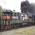
About a month ago, I mentioned in the D1 thread my working project to create a terrain-accurate Train Simulator version of the Back Road from Rigby to Waterville. I anticipated it being a year-long build, but I got a ton done during my week between jobs and managed to get a solid version together. Anyway, I ran a nighttime POWA from Rigby to Waterville with some Guilford SD40s and a bunch (100+) of tank cars — I called it my ad-hoc Oil Train — feel free to view the pictures here. I gave each picture an approximate (rounded) milepost so that it's easy to tell where one is.

Went 25 the whole way, and honestly I don't know how those of you who work/have worked on the railroad do it — let alone doing 10! That said, for someone who has always wanted to "ride the Back Road" it's probably the closest thing I (and others in my position) will get.

A few notes:
- There is an existing line built in the Portland area (called Maine Maritime) that has everything from OOB to just north of the Park Ave. bridge plus the Mountain Division and SLR through Portland to East Deering. With that, I took those and built out SLR to Danville, the Back Road to Waterville, and the Lower Road to Brunswick.
- All lines are treed to the extent realistic — I followed the Google Earth satellite view and tried to replicate it to the extent practical.
- I am pretty sure I have every signaled crossing between Portland and Waterville (no camp roads).
- Built out waterways/bridges for the following: Piscataqua River, Royal River x 3, Androscoggin River, Cochnewagon Pond, Maranacook Lake (with bridge), Messalonskee Stream. Still working on Messalonskee Lake.
- Overpasses/underpasses for the Falmouth Spur, Route 115, Route 9, Route 231, Penney Rd, Cobbs Bridge Rd, I-95 (Auburn), Lewiston Connector, Main St (Lewiston), Route 202, Route 135, I-95 (Auburn), Mayflower Hill Rd. Think I missed a couple of bridges but those are on the future list.
- I also took the liberty of giving a gate upgrade to Leeds Junction Rd, flasher upgrades to Black Cat Rd and Luce Rd, and making Readfield into CPFs (Bean and Packard) with distant signals as well (at Maranacook and Plains).

All told, I will keep refining this over time. There are very few buildings at this point (besides Portland and Auburn) and I know that some of my switches/etc. aren't currently real-to-life, but I'd give it a solid 7.5/10.
Last edited by petahgriff8316 on Wed Mar 30, 2022 1:17 pm, edited 1 time in total.
 #1594666  by markhb
 
Unfortunately, there's no actual link there.
 #1594847  by petahgriff8316
 
Assuming you have Train Simulator (Dovetail Games) I can share. PM me your email address and I'll send you the .rwp file which you can import (built with RailWorks). Again, plenty of missing things and not everything is exact to real life, but if you have time and interest to build stuff out, be my guest. Maybe it becomes a project with multiple contributors.

Come to think of it, all signaled crossings on the SLR and Lower Road (to Union St Brunswick) are in place.
 #1633680  by petahgriff8316
 
This went idle for a while, but with wrapping up my graduate studies in a few weeks I generally have more time as a result. Did some work on this project and feel like it's about ready to present — the line is built with almost all crossings and overpasses, with the immediate objective being to build out the Auburn/Lewiston and Waterville downtowns with semi-generic buildings, as well as Messalonskee, but for all intents and purposes there are trees where there should be. Assuming there was interest in a virtual ridealong, I could record or stream a given POWA-WAPO leg, as well as maybe a spin across the ex-SLR from East Deering to Danville.
 #1633718  by MEC407
 
I'd be interested in seeing that!
 #1633725  by eolesen
 
We host routes like this at Trainsim.com if you're interested in sharing with a worldwide audience. I'm assuming this is DTG RW or TS20xx compatible?

Sent from my SM-S911U using Tapatalk

 #1633905  by petahgriff8316
 
MEC407 wrote:I'd be interested in seeing that!
Great! I'll send you a PM once I have it ironed out and ready.
eolesen wrote: Thu Nov 23, 2023 9:15 am We host routes like this at Trainsim.com if you're interested in sharing with a worldwide audience. I'm assuming this is DTG RW or TS20xx compatible?
It is TS2022, and I'm happy to share, but it's definitely not "ship-ready" in terms of overall maturity (I'd say 80% of the way to where I think it needs to be). I need to finish up a few bodies of water and urban areas but learned a couple of tricks that have made both a lot faster, so it's coming along.
 #1635213  by petahgriff8316
 
Update: graduate program is over and we're almost there on this line. Figured out a way more efficient way to build lakes and terrain so made a ton of progress, pretty much all bodies of water built out and revamped overpasses. Grade is generally under 1.0% across the line, albeit there are plenty of sections with 0.9%. I have looked a bit at the track charts but not super close at the grades, they are probably steeper IRL at points. Still, I think it pretty accurately captures the spirit of the line, and used real Google Maps API to get elevation while smoothing where necessary. Only remaining spots to be treed are touch-ups in Portland and L/A, while Deering has been largely enhanced with buildings.

Taking PTO next week so will probably record some drives then and post the links unlisted on YT here. Probably start with BRK-POR Downeaster, POWA/WAPO, and maybe even a run from East Deering to Waterville via Danville (RIP SLR). Note that we will be going minimum 40 on the CSX/SLR runs since I do not have the patience for 25 (let alone 10 :P). God bless all of you who do it for a living.
 #1636090  by petahgriff8316
 
Finally got around to recording a drive on TS2022. BRK-POR (Union Station) on the Downeaster, while not technically a PAR/CSX train, is certainly a veritable presence between Portland and Brunswick, accounting for the vast majority of movements on a daily basis, let alone weekly or monthly, so I figured it would be a good place to start before going to a full Back Road recording. It's 720 pixels, so not great, but not the 360 (looks like it was recorded on a potato) that YouTube showed me immediately after upload. https://www.youtube.com/watch?v=aS8eDb4cyS4

Back Story (no pun intended): The GTrax Maine Maritime line has existed for quite a while, covering the section from roughly Brighton Ave. (albeit without the crossing) through Rigby and all the way to Pine Point, as well as the Eastern Prom street-level, the bridge by B&M, and the East Deering part of SLR to about the Falmouth town line. It is a mish-mash of historical and current elements, but it's really well-done (albeit the few floating houses/objects made me feel better) and I love it. As such, I built out from Brighton Ave. north to Waterville, the Brunswick Branch (through Maine Street crossing), and the (now inactive) portion of SLR from East Deering through Danville. It's very much a side project/work in progress, so it's not payware quality, but I always wanted a PAR line when playing MSTS back in the day — developing it was possible through the Tools extension, but would have required much more acumen than is necessary now — so I figured I'd build one instead! The elevation is sourced through the Google Maps API, and is pretty accurate. I just re-did the grades on a few major sections between Portland and Royal, as well as Winthrop through Belgrade, so I feel good about its realism from that perspective. The speed limits are not quite accurate (79 north of Forest Ave. to Waterville :joy: ) but I am working on fixing those with the old PAR TT.

A few other notes:
- I sound the horn/bell with 0 consistency. Sorry in advance to the purists. :smiley: I also tried to provide a variety of perspectives, but most of the video is from the locomotive or left-sided passenger perspective...the Amtrak Coach cars only have a view on the left side (given a forward direction of travel), which is weird, but I think the Cafe car might have a right-sided view; I know there are some double-deckers where there are views on both sides. Maybe it's time for a Superliner consist on POWA. :sweat_smile:
- 99% of the video (all but the last minute) is on my line, whereas the last minute is where the GTrax Maine Maritime package comes into play; you can definitely tell whose is the hack-job (generic houses shoddily placed) vs. the downtown, where it is accurate down to Hadlock Field. Credit where it is due!
- The GTrax package does feature the Portland Transportation Center, but I was more interested to see what a "no-holds-barred" approach between BRK and downtown Portland with no reverse move could look like. I doubt it would be 26 minutes end-to-end (it is currently scheduled as 50 with a stop in Freeport), but I think I read that the move adds 15 minutes alone, which is insane — not to mention Union Station being (a good bit) more strategically located Downtown Portland, even if not on the Waterfront.
- There are still some "floating" trees/houses/roads (where the terrain and object have a slight mismatch) but I am working on those as I see them.
- This brought to my attention a few "in progress" spaces, where there should either be trees (mostly) or buildings that have neither, particularly in Cumberland and around Riverside St through Forest Ave. Been doing a lot of work on SLR around Yarmouth Jct. and PAR near Waterville, respectively, but evidently neglected some spots closer to Portland.
- The signal at CPF 187 needs fixing — it used to be fine until I redid the grade between 185 and 189 to better mirror the real-world elevation. Do not read too much into motoring through it. :innocent: Also, I am missing the block signal at Read St. in Portland, but that is known — another casualty of redoing the grade.
 #1636158  by markhb
 
Very nice!
 #1636533  by petahgriff8316
 
Glad to see that there is some interest! Thank you to all who viewed.

As much as I wish I was posting a POWA/WAPO, I am instead reporting that I fried my computer on Tuesday spilling water. :imp: Tale as old as time, and the routes weren't backed. up, so I lost everything – the amount of storage space I'd need for FS2020 and TS2022 assets would be well beyond what I have stored already, so c'est la vie.

That said, the "good" news is that I was (and will be) in the market for an upgrade anyway, am a significantly more efficient (virtual) modeler vs. before, and have far more free time than any point in the past three years. Also, storage is getting cheaper by the year with Moore's Law, so maybe I back it all up this time. Be back soon with a new and improved CSX+SLR build.