As an individual involved in preparation of the map, I'm glad to see such enthusiasm for the new NYS rail map. I appreciate the feedback I've found here. There are a couple of good points raised here which I can clarify.
Lines Shown:
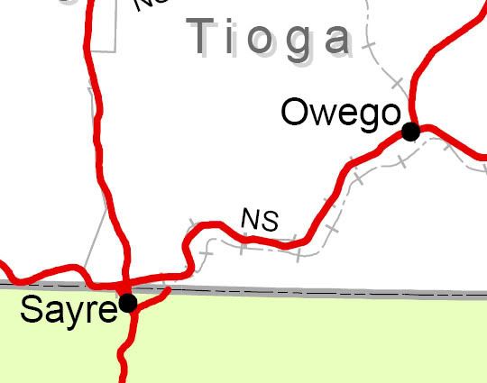
The map does not show all abandoned lines, but is the best available within NYSDOT at the time of publication. Based on the posts here, I have checked the data on the map against Russ Nelson's web site (which is very impressive!). Excluding trolley lines, which are not intended to be on the map, there are approximately an equal number of lines on Russ' map not on the NYSDOT map as there are lines on the NYSDOT map not in Russ' map. Over time, I anticipate the abandoned line coverage will be expanded to include those missing lines.
Note that active light rail / transit lines are not intended to be shown (SIRT, NYC Subway, PATH, etc..)
Inset Maps:
The inset maps do not show any abandoned lines at this time. Inclusion of the abandoned lines in the published map was a last minute decision. Unfortunately, there were some minor technical difficulties with the abandoned lines in the inset maps and ultimately the map was published without them, for now. Again, I anticipate that this will be addressed over time.
Abandoned vs. Active
The map depicts lines as abandoned only if they have gone through the formal ICC / STB abandonment process, or for non-jurisdictional tracks like Seneca Depot, if they are no longer connected to the active rail system.
NJT vs MNCR on Southern Tier:
There are a number of equally valid ways to label the rail lines where track ownership, dispatching, maintenance, and operations are separated, such as the Southern Tier. For the map, it was decided to define the operating railroad as the entity who publishes the employee timetable for a given route, regardless of ROW or track ownership, maintenance responsibility, dispatching, etc... , all of which could (and does) vary from who publishes the ETT. Any of the other methods produced results which would have raised far more questions...
Ray
Lines Shown:
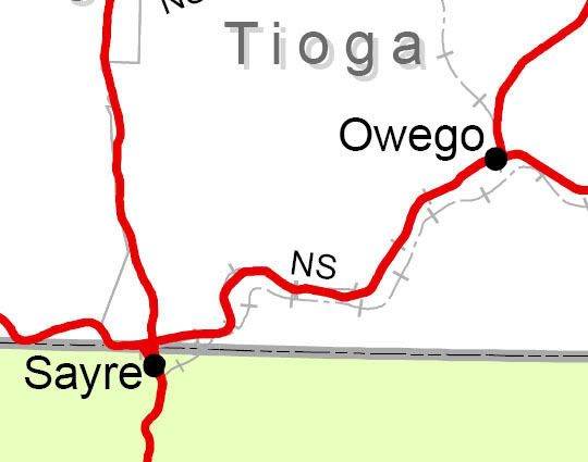
The map does not show all abandoned lines, but is the best available within NYSDOT at the time of publication. Based on the posts here, I have checked the data on the map against Russ Nelson's web site (which is very impressive!). Excluding trolley lines, which are not intended to be on the map, there are approximately an equal number of lines on Russ' map not on the NYSDOT map as there are lines on the NYSDOT map not in Russ' map. Over time, I anticipate the abandoned line coverage will be expanded to include those missing lines.
Note that active light rail / transit lines are not intended to be shown (SIRT, NYC Subway, PATH, etc..)
Inset Maps:
The inset maps do not show any abandoned lines at this time. Inclusion of the abandoned lines in the published map was a last minute decision. Unfortunately, there were some minor technical difficulties with the abandoned lines in the inset maps and ultimately the map was published without them, for now. Again, I anticipate that this will be addressed over time.
Abandoned vs. Active
The map depicts lines as abandoned only if they have gone through the formal ICC / STB abandonment process, or for non-jurisdictional tracks like Seneca Depot, if they are no longer connected to the active rail system.
NJT vs MNCR on Southern Tier:
There are a number of equally valid ways to label the rail lines where track ownership, dispatching, maintenance, and operations are separated, such as the Southern Tier. For the map, it was decided to define the operating railroad as the entity who publishes the employee timetable for a given route, regardless of ROW or track ownership, maintenance responsibility, dispatching, etc... , all of which could (and does) vary from who publishes the ETT. Any of the other methods produced results which would have raised far more questions...
Ray