Railroad Forums 

  • LIRR History (Valley Stream) and Surrounding areas.

  • Discussion of the past and present operations of the Long Island Rail Road.
Discussion of the past and present operations of the Long Island Rail Road.

Moderator: Liquidcamphor

 #141288  by Long Island 7285
 
Does any one have information of the location of the origional valley stream station?

I read in a local history book that the station was located between first and third street. if this is true, could this have been on the east or west leg of the wye connecting to the WM branch? when elevated was the far frock branch moved west a bit? and does any one know weather or not the blue bridg taking sunrise hwy. over the belt and becoming conduit ave. is infact origionally the LIRRs bridg before elevation of rosedale-lynbrook?

 #141543  by Dave Keller
 
OK . . . . .

Here we go:

I can’t tell you about the location of the “original” Valley Stream depot without major research, but the 2nd Valley Stream depot, the one in service until the 1933 grade crossing elimination, was located south of the Montauk branch tracks and on the west side of the Rockaway Avenue crossing, with a low platform along the Montauk branch tracks (north and south sides) and a curved low platform along the east leg of the wye, south of the Montauk branch, connecting the Far Rockaway branch with the Montauk branch. The wye made its connection to the Far Rockaway branch directly across Roosevelt Avenue.

There were also low, curved platforms with shelter sheds along the #1 and #2 tracks of the Far Rockaway branch. These were located north of Roosevelt Avenue and East of Franklin Avenue, about where Sunrise Highway now passes under the LIRR.

The lay-up yard, consisting of eight (8) tracks, was located west of the depot, also south of the Montauk branch tracks and east of Franklin Avenue. An electric sub station, designated #9A, was constructed in 1930 between the yard tracks and the east leg of the wye.

“VA” tower was located south of the Montauk branch tracks and at the very west end of the station platform.

The freight house was located south of the Montauk branch tracks on the west side of Franklin Ave. There was a house track and 2 team tracks. This would be where the south parking lot of the depot now stands.

The water tower and plug were south of the Montauk branch tracks on the east side of the Rockaway Avenue crossing and east of the east leg of the wye where it joined the Montauk branch.

Sunrise Highway did not cross the Far Rockaway branch prior to the 1933 grade elimination. (The station platforms on the Far Rockaway tracks and part of the lay-up yard were located where it later would cross under the tracks.)

After the grade elimination of 1933, the Far Rockaway tracks remained in their same locations. The east leg of the wye, however, was removed. and the tracks were elevated over Roosevelt Avenue as well as the new Sunrise Highway extension.

The station stop was relocated west of Franklin Avenue, with the new, elevated structure crossing Franklin Avenue and part of the elevated platform being located over Hicks Street.

Sub-station #9A appears to be in its same location. A new freight house with house track and two (2) team tracks were constructed on the site of the old lay-up yard, only now elevated.

A new “VA” (later “VALLEY”) tower was built slightly further west of its original location.

Image

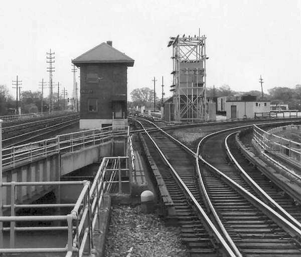
This photo, looking east, shows both the tower and the team tracks with freight cars in the background. The small power plant IS NOT substation #9A.

As for the Sunrise Highway bridge of which you spoke: I don't believe that bridge was ever part of the LIRR system. I believe it was constructed solely for highway use.

Dave Keller

 #141664  by Long Island 7285
 
Thanks alot dave,

and the 9A substation aparenly still stands where constructed in 1930. ill have to get some photoes to post.

now some one at my job told me that he remembers a sideing in lynbrook (not the REA sideing where walbumbs and mavis tire is) but a sideing on union avenue in lynbrook? does any one know anything about it? maby JJ.

 #141973  by mp15ac
 
An interesting fact about the Valley Stream elevation project was that is was done by none other than Robert "Anti-railroad" Moses. Apparently he was asked by someone to do it (I guess they asked very nicely) and he agreed.

Stuart

 #142039  by Long Island 7285
 
15ac, thats an intresting fact.

if one looks at valleys elevation then lynbrook and RVC, Valley is "over built" support colums everywhere.

 #142054  by Dave Keller
 
Could also be a sign of the times:

Valley Stream was 1933. One of the early elimination projects. They may have carried over the techniques and quality of the Jamaica Improvement East project of 1929-30 (Union Hall Street to Hillside).

Quality of construction perhaps got cheaper for Lynbrook in 1938, and RVC in 1950.

1950 was a bad year financially for the LIRR (not to mention in other respects as well.) The elimination couldn't have been easy on the $ situation. With money an issue, why go overboard when you could do something similar for less?

Just a thought.

Dave Keller

 #142258  by Long Island 7285
 
Dave,

in a way, as one leaves valley east along sunrise watching the elevated structure you can almost put a time period in LIRR history to when it was built. what im saying is, the changes in the structure from valley east just about tells its own story.

now does any one know of a sideing in lynbrook used for an oyster business?
from what i was told be an indivisual remaining annoyomus, is that before elevation, there was a sideing alond union ave in lynbrook? any maps or records about it?

 #142473  by Dave Keller
 
Here’s what I’ve come up with:

Prior to the grade elimination at Lynbrook, there was a coal siding off the Long Beach branch just south of the Sunrise Highway crossing, at the end of the Lynbrook station platforms that serviced the Long Beach branch trains. This is the ONLY siding I see that was in the vicinity of, and MAY have crossed, Union Avenue, but as Union is not listed on my reference maps as a street crossed by tracks, perhaps it's not the one of which you speak.

All the other sidings at Lynbrook when at grade were east of Union.

There was a 25 car siding, known as the “sub-station track” south of the Montauk branch tracks, to service sub-station #4 as well as the H.W. Fieseler Co. Lumber Yard. It crossed Earle and Forest Avenues.

There was a 15 car team track north of the Montauk branch tracks, crossing Earle Avenue. The freight house was located there between the team track and the north passing siding.

A 2 car siding north of the Montauk branch just west of Denton Avenue serviced the coal yard of A. W. Schoppe.

A 5 car siding north of the Montauk branch tracks and east of Ocean Avenue serviced Dependable Fuel.

There was a 6 car siding north of the Montauk branch, crossing Ocean Avenue to service the Queensborough Gas & Electric Co.


Up until 1926, the LIRR tracks were paralleled on the north side of the Montauk branch by the tracks of the NY & LI Traction Co. with a passing siding located within Stauderman Avenue. The trolley line then continued further east and crossed the LIRR on a NW/SE diagonal overhead bridge, located between Rocklyn and Ocean Avenues. Once south of the Montauk branch tracks and crossing Ocean Avenue, a number of trolley sidings were in place near the line’s power house, probably as lay-up tracks.

The line then continued on to Freeport.

The LIRR had a siding south of the Montauk branch tracks and east of Ocean Avenue to deliver coal to the NY & LI Traction Co.’s above-mentioned power house. (The powerhouse was on the east side of Ocean.)

Sorry. . . . .. no Oyster siding. Probably urban legend.


Dave Keller

 #142551  by EdM
 
[quote="Dave Keller"]Here’s what I’ve come up with:
. The trolley line then continued further east and crossed the LIRR on a NW/SE diagonal overhead bridge, located between Rocklyn and Ocean Avenues. Once south of the Montauk branch tracks and crossing Ocean Avenue, a number of trolley sidings were in place near the line’s power house, probably as lay-up tracks.

The line then continued on to Freeport.


I saw the remains of what someone told me were trolly tracks in the late 40's crossing the creek between VS blvd and the RR at what is now the village green and someone told me the trolly used to run along Jamaica ave to Freeport... I know that one could walk to Lynbrook along the north of the RR in the forties, following Jamaica ave then across Horton to lynbrook.... Ed

 #142776  by Dave Keller
 
Amazing that it was still visible as late as the 1940s!!!

Dave Keller

P.S. The locals in Freepot nicknamed it the "Toonerville Trolley" after that classic comic strip about a trolley having a hard time staying on the rails. I understand the trolley would rock from side to side as it headed across swampland in Freeport, threatening to derail, which, I believe, it did from time to time. Hence the nickname! DK

 #142863  by EdM
 
Dave Keller wrote:Amazing that it was still visible as late as the 1940s!!!

Dave Keller

P.S. The locals in Freepot nicknamed it the "Toonerville Trolley" after that classic comic strip about a trolley having a hard time staying on the rails. I understand the trolley would rock from side to side as it headed across swampland in Freeport, threatening to derail, which, I believe, it did from time to time. Hence the nickname! DK
well, it was more remains than tracks, and the clew that got the ten year old boy interested was the quality of the bridge here in the woods, 'twas one of those bridges with three or so culvert pipes and graded well above the grade of the creek and the surrounding terrain.... and the grading of what had to be a "road" running east and west here in the woods...cause the terrain level was destroyed when they made the "village green" and bandstand sometime in the fifties, when I wuz filling sandbags fer the army (ours I think) in El Paso..... Ed

 #142869  by Sir Ray
 
EdM wrote:well, it was more remains than tracks, and the clew that got the ten year old boy interested was the quality of the bridge here in the woods, 'twas one of those bridges with three or so culvert pipes and graded well above the grade of the creek and the surrounding terrain.... and the grading of what had to be a "road" running east and west here in the woods...cause the terrain level was destroyed when they made the "village green" and bandstand sometime in the fifties, when I wuz filling sandbags fer the army (ours I think) in El Paso..... Ed
Hmm, remember that directly north of the LIRR (Montauk Branch) in Valley Stream and Lynbrook (and RVC too..) ran the 'pipeline', which used to supply Queens with water (from Freeport, I believe) . NYC owned this easement for decades, even after the pipeline ceased to carry water, only selling it in the 1980s (about the time that Valley Stream removed the part of the pipeline crossing the stream that leads to Mill Brook, and replaced it with a small pedestrian bridge). The Pipeline is the reason that S. Franklin (I think it's south Franklin - I only drive on it every day, and never look at the Street Names) has that steep grade directly North of the Valley Stream Station...

From Newsday:
http://www.newsday.com/community/guide/ ... navigation
1) it was Brooklyn, not Queens (well, Valley Stream was a part of Queens at the time...)
2.) They said the pipline ran under Sunrise Highway, but I am positive that the section in Valle Stream/Lynbrook ran north of the LIRR (and hence North of Sunrise). The first reseviour eventually became Hempstead Lake, and as the pipeline was pushed further east a pumping station was build in Freeport (hence my earlier misconception about freeport being the source of water - sources as far east as Massapequa were used)

 #142882  by Dave Keller
 
There was also a huge, red-brick pumping station trackside in Baldwin as well (north side of tracks) and I remember seeing small pump houses north of the LIRR prior to the grade eliminations, with the water conduit at some instances above ground and some small bridges over the many streams.

Dave Keller
  • 1
  • 2
  • 3
  • 4
  • 5
  • 7