• Irene Thread: Sat Noon Shutdown?

  • Discussion of the past and present operations of the Long Island Rail Road.
Discussion of the past and present operations of the Long Island Rail Road.

Moderator: Liquidcamphor

  by jonvit69
 
Site Admin: The OP's topic was somewhat hijacked; apologies to the OP. I went ahead and retitled and merged into another hurrican topic.

planning to go to riverhead from yaphank this weekend.any specials running for the railroad festival in riverhead?
  by Morisot
 
Hurricane Irene might have some effect!
  by Doc Emmet Brown
 
There is a very good chance that LI could be hit by a cat 2 huricane by sunday.. a cat 2 would flood to sunrise highway, and millions would be without power. The weather channel just said at 355pm that if the models hold true it wil be the worst storm in the north east since the 30's.
The one in the 30's created the moriches inlet.... think about it..
  by Doc Emmet Brown
 
There is a very good chance that LI could be hit by a cat 2 hurricane by sunday.. a cat 2 would flood to sunrise highway, and millions would be without power. The weather channel just said at 355pm that if the models hold true it wil be the worst storm in the north east since the 30's.
The one in the 30's created the moriches inlet.... think about it..good night irene...

http://www.youtube.com/watch?v=nGd4jkaoHRg
  by LongIslandTool
 
"Very good chance"? Me thinks not. Ignore the Newsday "global-warming-end-of-life-as-we-know-it" hype.

Here's the National Weather Service Forecast for Jamaica NY:

Sunday: Rain and possibly a thunderstorm. High near 76. Chance of precipitation is 80%.

Sunday Night: Rain likely and possibly a thunderstorm. Some of the storms could produce heavy rainfall. Mostly cloudy, with a low around 69. Chance of precipitation is 60%.
  by RickRackstop
 
At this point it looks like the storm is headed directly towards Providence, RI, exactly as the 1938 storm did. Since then they have taken the precaution of building a dyke with flood doors at the streets to prevent the storm surge from flooding the city. Anyway every time they have updated the storm track it keeps moving east offshore and it hasn't hit the Bahamas yet. This should be interesting. The other factor is that 1938 storm was moving north at about 50 mph while this one is at the more customary 10 to 15 mph.
  by Amtrak7
 
Looks like, if the models hold true, busing east of Speonk/KO won't be enough.

I'm afraid the entire Montauk east of VALLEY will be a problem, and the Far Rock/Long Beach will definitely be out.
  by num1hendrickfan
 
LongIslandTool wrote:"Very good chance"? Me thinks not. Ignore the Newsday "global-warming-end-of-life-as-we-know-it" hype.
From what I'm reading and replying to at the forums over at Accuweather.com , I'd say you're grossly under-estimating the potential impact of this event. All the models are in agreement of a major hurricane striking North Carolina ( probably the outer banks at Cat-4 strength ), and then bring a Category 2 ( possibly Category 3 if it doesn't weaken fast enough ) up into the megalopolis that is Bos-Was shortly there after ( time frame Saturday night into Sunday morning ).

I'm not to surprised to see a reply like yours though, no one including myself has lived through a real hurricane here on Long Island and the real impacts that would be felt here on Long Island from one.
  by Morisot
 
Young'uns! 1979 hurricane David, in the middle of Nassau County we lost power for 5 (FIVE!) days.
  by nyandw
 
The Nat'l Weather Service Forecasts differ from their Hurricane forecasts, for example for Oak Island, NC (already in evac) Here's the forcasts:

Friday: Tropical storm conditions possible. Showers and thunderstorms likely. Cloudy, with a high near 85. East wind 20 to 25 mph, with gusts as high as 30 mph. Chance of precipitation is 70%. New rainfall amounts between a half and three quarters of an inch possible.

Friday Night: Tropical storm conditions possible. Showers and thunderstorms likely. Cloudy, with a low around 77. Chance of precipitation is 70%. New rainfall amounts between three quarters and one inch possible.

Saturday: Tropical storm conditions possible. Scattered showers and thunderstorms. Mostly cloudy, with a high near 82. Chance of precipitation is 50%. New rainfall amounts between a quarter and half of an inch possible.
_______________

On the Hurricane page the view is far different. It appears this may be the near landfall location (thus far) or on the more powerful left of the eye.

The report for Long Island is not reflective of the Hurricane potential. I'm not buying the Newsday's global nonsense either, BTW. Hurricanes have been around since the Earth oceans formed.
  by nyandw
 
Long Island Big Hurricanes:

1938 Sep NY, 3; CT, 3; RI, 3; MA, 3 3 Moriches Inlet

1960 Sep FL, SW4; NC, 3; NY, 3; FL, NE2; 4 930 ----- Donna
CT, 2; RI, 2; MA, 1; NH, 1; ME, 1

Cat 3 across LI Suffolk County Hamptons a major disaster, almost a breach at the "weak" point between Cherry Grove/Pines. A slow moving monster lasted forever, it seemed, from the perspective of an 11 year old.


1985 Sep NC, 3; NY,3; CT,2; NH,2; ME,1 3 942 90 Gloria

Cat 3 across at Babylon (I believe) However at 20+ mph the transit time was much quicker then usual, thus less damage. Blasted across LI in 1 hour. I spent 10 minutes in the eye, amazing. 100-200 plus year old trees bent over parallel to the ground. But electric out in Patchogue, for example 5 days, other locales up to 10 as I recall.

Hurricane listings by years: http://www.aoml.noaa.gov/hrd/hurdat/ushurrlist.htm

Guys been through 5 in Florida in a decade: Get water, batteries, dry consumables, water in bathtubs,fill the tank, move all the items that become missiles from the yard, prepare for pet shelters, important papers with you, CASH (ATM go away), meds, entertainment, radios... My short list.

[Side Bar] Earthquakes exist on the east coast and have for millions of years. The Appalachian formations are much older 9then the Rockies) and the rock "less fluid". Fewer quakes, duration, strength, but tremor transmission is greater over longer distances. Caused by more global warming nonsense... To fund more nonsense programs, perhaps? LOL
  by nyandw
 
Hi Doc, Amtrak & Folks:

Long Island Big Hurricanes:

1938 Sep NY, 3; CT, 3; RI, 3; MA, 3 3 Moriches Inlet

1960 Sep FL, SW4; NC, 3; NY, 3; FL, NE2; 4 930 ----- Donna
CT, 2; RI, 2; MA, 1; NH, 1; ME, 1

Cat 3 across LI Suffolk County Hamptons a major disaster, almost a breach at the "weak" point between Cherry Grove/Pines. A slow moving monster lasted forever, it seemed, from the perspective of an 11 year old.


1985 Sep NC, 3; NY,3; CT,2; NH,2; ME,1 3 942 90 Gloria

Cat 3 across at Babylon (I believe) However at 20+ mph the transit time was much quicker then usual, thus less damage. Blasted across LI in 1 hour. I spent 10 minutes in the eye, amazing. 100-200 plus year old trees bent over parallel to the ground. But electric out in Patchogue, for example 5 days, other locales up to 10 as I recall.

Hurricane listings by years: http://www.aoml.noaa.gov/hrd/hurdat/ushurrlist.htm

Guys been through 5 in Florida in a decade: Get water, batteries, dry consumables, water in bathtubs,fill the tank, move all the items that become missiles from the yard, prepare for pet shelters, important papers with you, CASH (ATM go away), meds, entertainment, radios... My short list.
  by Doc Emmet Brown
 
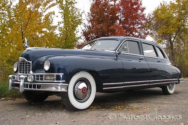
I remember donna, I was 6 and a half, my dad took us out in the Packard after the storm to survey the damage.. lots of trees down.
Yeah we had a packard limo, jumpseats the whole deal cool car..
while not the exact car, it might be.. i got a one in 50 chance, only 50 of that model were made.' Grandpa had bucks and gave it to my dad after a few years. Gas was only 20-25 cents a gallon back then.
I used to call it the queen mary, it was like a traveling living room.
As i recall the car had a Straight 8 cylinder engine.. look how long the hood is...

Image
  by ADL6009
 
LongIslandTool wrote:"Very good chance"? Me thinks not. Ignore the Newsday "global-warming-end-of-life-as-we-know-it" hype.

Here's the National Weather Service Forecast for Jamaica NY:

Sunday: Rain and possibly a thunderstorm. High near 76. Chance of precipitation is 80%.

Sunday Night: Rain likely and possibly a thunderstorm. Some of the storms could produce heavy rainfall. Mostly cloudy, with a low around 69. Chance of precipitation is 60%.

if that forecast comes true that alone will be enough to cripple the RR as it has the last 2 sundays. you better hope this hurricane is all smoke and mirrors. i hope there are people upstairs at least considering that sunday might be a difficult day.
  by ADL6009
 
btw tool, last sunday we had a tree or trees across the tracks west of rosedale. how come it takes so long to send someone out with a chainsaw, cut apart the tree and roll the logs away from the tracks? it took 12 hours to clear one tree. how is that possible?
  • 1
  • 2
  • 3
  • 4
  • 5
  • 7