Discussion of the past and present operations of the Long Island Rail Road.

Moderator: Liquidcamphor

  by nyandw
 
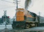
Recent arrival: PRR-leased K4s and train in LIRR third rail territory, approaching manual crossing. siding branching off in the foreground - c. 1935.

Anyone recognize the location/buildings? Thank you.
You do not have the required permissions to view the files attached to this post.
  by MACTRAXX
 
Steve - This location baffles me...I will at least narrow it down somewhat taking note to the steam train and
third rail present it is the Montauk Branch somewhere east of Freeport and west of Babylon - or it could be the
Main Line in the New Hyde Park area making the most sense to me being electrified in the 1930s...

This looks to be a westbound train with the telegraph pole line on the south side and electric transmission
lines on the north side of this double track route with a siding beginning at the pictured grade crossing...

The sign name on the visible lineside store could offer a further clue - if it was more readable and not partially
blocked by the pole in the photo...Enlarging this picture on my device offers me nothing extra in this instance...

A further tip-off is a then-moderately developed area outside of a downtown core on these two LIRR routes...
For all we know what existed then is now long gone today other then the right of way...MACTRAXX
  by nyandw
 
MACTRAXX, et al.: Every Emery map on the Main Line and Montauk branch that had grade crossings in electrified territory and the only location that is close to the photo with the siding branching off in the foreground is Broadway in Amityville. It's possible (for certain) that the landmarks changed between the image shot in the mid-1930s and the way it looks 90 years later. (As you surmised!) Thank you.
  by MattAmity90
 
If it is Amityville, it would make sense of the crossing being Broadway/Route 110. It wasn't until the 1960s that Route 110 was widened. This could also be Lindenhurst because sidings were located there. As soon as the elevation project started in October 1968 the landscape of both towns changed drastically. Whatever that store is, it's now a Walgreen's. If only the photo was further back because Pete's Diner is behind the photographer.