• Early Amtrak map used in Silver Streak movie?

  • Discussion related to Amtrak also known as the National Railroad Passenger Corp.
Discussion related to Amtrak also known as the National Railroad Passenger Corp.

Moderators: GirlOnTheTrain, mtuandrew, Tadman

  by CP-4070
 
Hi guys,

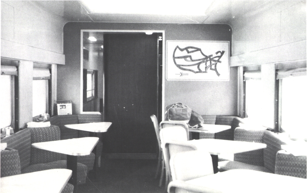
being a Silver Streak "enthusiast" for many years, I was watching the film again and again to have detailed looks at some details. The system route map that is visible e.g. in the diner car, of the fictive road AMRoad always catched my eyes and I thought, it was a movie prop, designed for the film to make the appearance of that road more realistic. It was like that until I saw a photograph in the book Amtrak Trains & Travel last weekend, showing exactly the map, used in the movie.

http://www.erixrailcar.com/history/amtk_dorin.jpg" onclick="window.open(this.href);return false;

Now I am wondering if anybody can tell, if that was an official design, used by Amtrak. Maybe it even has a name of the artist, etc and second, if the interior shots of the Silver Streak movie were done in CP cars, like I assumed all the time or was done in Amtrak cars. I thought that one maybe can judge by comparing the pattern of the wall carpets?

It would be awesome if some of you guys could help out here.

Thanks a lot, Andrew
  by Greg Moore
 
Hmm, I have no idea if that's an actual Amtrak Map, but I do find it interesting in a few key details.

It shows the Crescent route in a different color, so presumably this is when the Southern was still running it.
It also shows the Rio Grande, which survived A-Day.
It also shows the Empire Service, but NOT the Lake Shore Limited.

So if it's NOT a real Amtrak "map" (and given the logo, I suspect it is) the creator certainly strove for some accuracy on detail.
  by CP-4070
 
Yes, the map in the picture is out of an Amtrak car. The movie Silver Streak was done in 1976 and it did appear in that movie by then. Thus, it must be a pre-1976 map.
  by Amtk30
 
I too seem to recall seeing that map, or at least a close variation of that map, from several Amtrak travels during the 70's (mainly #40-#41). That Dorin pic shows a very unique car interior, before the red and purple color splash. Perhaps a sleeper-lounge or a pre-VIA pub car?

Amtk30
  by Gilbert B Norman
 
I'll confirm, as one for whom it's a "been there done that" that map is authentic Amtrak, and it was posted in a number of cosmetically refurbished cars (gee, they looked nice at a station; not so nice when the AC went AWOL as soon as the station standby was unplugged).

The car interiors were simply Hollywood stage sets.

Wisely, Amtrak wanted nothing whatever to do with that production. Why Canadian Pacific did escapes me.

Simply too many Rules violations depicted, starting with pretending a signal bridge was a trapeze.

Finally regarding the interior photo our colleague from overseas located, a little more digging found this (BNG is Amtrakese for Burlington Northern Great Northern):

http://www.erixrailcar.com/history/amtk_equip1.jpg" onclick="window.open(this.href);return false;
Last edited by Gilbert B Norman on Mon Nov 14, 2016 6:17 pm, edited 1 time in total.
  by NH2060
 
I too wondered at one point exactly which routes were meant to be depicted in that map. I thought it was a studio map with rough outlines just for the movie. I think it was the same situation with the vacation poster used in the beginning of Dark Shadows where Victoria Winters takes the Downeaster (not a prop, but an actual poster with the old "pointless arrow" logo).


To GBN: I read somewhere once that one reason why Amtrak objected to having any participation in the film was because of the part in the script where the door to Hilly's compartment opens by accident. Also the fact that Amtrak was still trying to "legitimize" itself 5 years after its creation (they had yet to officially acquire their share of NEC at that time) and therefore didn't want any bad "Hollywood PR problems" played a role. CP Rail probably figured "well it's set in America so it's technically not our train if it's a different RR and we'll get paid for it so yeah why not?" I'm glad they did as that movie essentially made me a fan of CP Rail "bulldogs" for life!
  by jhdeasy
 
I remember seeing that map on the wall of Amtrak refurbished 6400 series coaches assigned to Empire Service trains circa 1974. Note the map's gap (no service) between Buffalo NY and Detroit MI. On some of the cars, someone (an employee?) had placed tape over the Buffalo - Detroit gap on the map and hand-written "Close the gap!" on the tape. The gap in service west of Buffalo was finally closed on October 31, 1975 when the Lake Shore Limited began operations.

Interesting to note the Amtrak service map identified the Southern Railway and the Denver & Rio Grande Western service routes with the dotted lines, but it did not do that for the Rock Island or the Georgia service routes.
  by NS VIA FAN
 
jhdeasy wrote: Interesting to note the Amtrak service map identified the Southern Railway and the Denver & Rio Grande Western service routes with the dotted lines, but it did not do that for the Rock Island or the Georgia service routes.
Or the connecting Penn Central-TH&B-CP Buffalo-Toronto train
  by Ridgefielder
 
Gilbert B Norman wrote:Finally regarding the interior photo our colleague from overseas located, a little more digging found this (BNG is Amtrakese for Burlington Northern Great Northern):

http://www.erixrailcar.com/history/amtk_equip1.jpg" onclick="window.open(this.href);return false;
I'm somewhat fascinated by this piece of equipment. What service was it used in by the Great Northern, and what routes did Amtrak use it on?
  by CP-4070
 
Thanks guys for your comments so far. If I summarize, the assumption is close, that the film production team used a then official Amtrak map in their movie set for the car interiors. Now I am sure that the one or other can assume my next question: Any idea where to find a larger version of that map to re-create it? And yes, I searched google for all thinkable variations of "Amtrak", "map", "poster", "vintage" etc. :-)

Best wishes, Andrew
  by jhdeasy
 
In looking thru my library of railroad books, I found one book containing two photos of this route map mounted on an interior wall of Amtrak Heritage passenger cars.

Amtrak Trains & Travel
by Patrick Dorin
Superior Publishing Company
Seattle, Washington
1979

page 91, on the interior wall of a former Great Northern coach diner (the photo previously referenced in this discussion thread)
page 97, on the interior wall of a former Southern Pacific three-quarter dome lounge

The most likely place where you might find this stylized route map is in interior photos of refurbished Amtrak cars during the early 1970s. Unfortunately, the vast majority of online photos of Amtrak passenger cars from that era are exterior photos.

You might also find it in Amtrak marketing material (printed brochures or advertisements) from that era. I think the system timetables had a more detailed route map, rather than this stylized graphic.

Ridgefielder said "I'm somewhat fascinated by this piece of equipment. What service was it used in by the Great Northern, and what routes did Amtrak use it on?"

In response to Ridgefielder's question about Amtrak coach diners 8400 and 8401 (former GN coach diners 1145 and 1146), they were built by ACF in 1950 for GN's International between Seattle WA and Vancouver BC.

http://www.gn-npjointarchive.org/Lists/ ... px?ID=1577
http://rrpicturearchives.net/showPictur ... id=2718208
http://rr-fallenflags.org/amtk/amtk-s8400akg.jpg
https://www.flickr.com/photos/mbernero/23671854679

The former Amtrak 8401 / GN 1146 survives at the Minnesota Transportation Museum.
http://transportationmuseum.org
If you go to their website, and look for the equipment collection, passenger cars, you will find an extensive history of the two cars with photos.