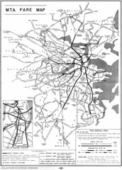
Railroad Forums 

  • Vintage rapid transit maps

  • Discussion relating to commuter rail, light rail, and subway operations of the MBTA.
Discussion relating to commuter rail, light rail, and subway operations of the MBTA.

Moderators: sery2831, CRail

 #638562  by Charliemta
 
As a child I distinctly remember seeing the map posted on the walls of subway trains and stations in the 1950's and early 60's, up until the MBTA was formed. I definitely remember seeing it on the old pre-1963 vintage Red line trains (though of course it wasn't called the Red Line back then).
 #638569  by Otto Vondrak
 
I'll say mid-1950s for now.

Here's another MTA treat!! Anybody know what date? "Blue Line" ends at Maverick.

Image

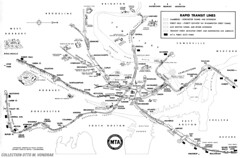
http://flickr.com/photos/ottomatic77/32 ... 9/sizes/l/
 #638570  by TomNelligan
 
The first map doesn't show the Riverside line branching off the Beacon Street trackage, so that dates it as pre-1959. But Braves Field has become University Field, so that dates it as 1953 or later (the Braves moved to Milwaukee after the '52 season). That narrows your window to about six years.

As for the second, the MTA was created in 1947 and what is now the Blue Line was extended from Maverick to Orient Heights in 1952.
 #638616  by 3rdrail
 
1954 and 1949.
The first map is dated by the fact that both the Revere Extension to Wonderland was completed, and Day Square became Wood Island- all in 1954.
The second one...well, you'll just have to ask that guy Charlie- ("He's the man who never returned".)
 #638804  by Otto Vondrak
 
Thanks, everyone. I updated the dates on the pages accordingly.

If I come across any other goodies in my collection that I can fit on the scanner, I will share them.

-otto-
 #638850  by 3rdrail
 
Fred Rabin wrote:Thye second map was 1948.
Fred -
Although the MTA succeeded the BERy in 1947, the Boston Transit Department operated the system (and set fares) until July 2, 1949. As the map does not state "Effective July 2, 1949", we can only assume it to not be issued prior to this date. Also, the famous "MTA" song has Charlie paying the exit fare on his infamous trip to JP from Cambridge for a total fare of 15 cents- the same fare that would have been indicated on this map/guide.(Cambridge-Dorchester Subway to Arborway Line) This exit fare was a source of controversy and confusion regarding it's proposed fare increase and was a hot topic at the time of the campaign for the 1949 Boston mayoral election, which would have later prompted the issuance of such a guide. (The song was written for mayoral candidate Walter O' Brien who was anti-fare increase, who lost to John Hynes. O'Brien's name gets conveniently changed to "Charlie" by the Kingston Trio in this version.)

http://video.google.com/videosearch?hl= ... 4&ct=title#
 #639624  by jonnhrr
 
3rdrail wrote:O'Brien's name gets conveniently changed to "Charlie" by the Kingston Trio in this version.)

http://video.google.com/videosearch?hl= ... 4&ct=title#
Actually they changed it to "vote for George O'Brien".

Also, I was wondering - back in the day the Arborway line looped at Park St - so how did Charlie end up going through Scollay Sq so that his wife could hand him a sandwich?

Jon
 #639632  by 3rdrail
 
Jon-
Listen to it again. Kingston Trio lead singer Nick Reynolds goofs up (I think on purpose) and sings, "Fight the fare increase, vote for Charlie O'Brien, and get old Georgie off the MTA." The basis for this "inside joke" may have been an earlier criticism of using the name "Walter O'Brien" in the song, who was illegitimately branded as a Communist. "Walter O' Brien" then traditionally became "George O' Brien" in the singing of the song afterwards at the time. This may be the Kingston Trio's "revolt" of this conservative knee-jerk reaction (since they were such a rebellous group :-D ). As regards to the second question, if we start looking for complete accuracy in movies, songs, newspapers, and call girls, we are going to have a long search.
 #639680  by Otto Vondrak
 
On this map...

Image

On the Harvard end of the "Red Line" it looks like the tracks emerge from a tunnel to open air to... a possible extension? Or just artist's wishful thinking? Same with Everett, it shows the "Orange Line" like it might continue off the page to Malden.

-otto-
 #639690  by danib62
 
Otto Vondrak wrote:On this map...

Image

On the Harvard end of the "Red Line" it looks like the tracks emerge from a tunnel to open air to... a possible extension? Or just artist's wishful thinking?...

-otto-
Nope, that's just the old Eliot Yard that was closed in the 70's.
 #639702  by 3rdrail
 
Otto Vondrak wrote:On this map...

Image

On the Harvard end of the "Red Line" it looks like the tracks emerge from a tunnel to open air to... a possible extension? Or just artist's wishful thinking? Same with Everett, it shows the "Orange Line" like it might continue off the page to Malden.

-otto-
...or, it's a reference to Stadium Station, a temporary station used to transport the throngs of spectators out of Harvard Stadium during games, which did exactly that- exit the subway. Since they picture Harvard Stadium on the map also, I'd go with that. They do, however, visually extend all their stub-end rapid transit lines beyond their terminals. Perhaps, it was a suggestion of future expansion otherwise.