Railroad Forums 

  • Rockaway Beach Branch - Historical Operations

  • Discussion of the past and present operations of the Long Island Rail Road.
Discussion of the past and present operations of the Long Island Rail Road.

Moderator: Liquidcamphor

 #922623  by UN Block
 
When I hiked the line in 1979 (!) there were remnants of every signal from south of Rego Park all the way to Ozone Park. Of course, all of the mileposts were still in. The only property that been encroached upon at that time was the parking lot for the Forest Park Crescent apartments. Alas, the trees are MUCH bigger today.

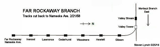
I believe at least three of the LIRR mileposts are still intact on the subway-operated portion; one near Aqueduct, one near Playland and one somewhere on the Far Rockaway Branch.
 #1384609  by Ocala Mike
 
Can still hear the announcer at Jamaica Station - "Gibson, Hewlett, Woodmere, Cedarhurst, Lawrence, Inwood, and Far Rockaway - train on track 6."
 #1450516  by newkirk
 
Any comments and input are welcome.
Looking towards the Rockaway peninsula. Should the steel structure be for the NYCTA Rockaway line station and overpass ? June 25, 1955


Image

I believe the photographer turned around and faced north towards Hamilton Beach. Correct ? June 25, 1955
Image
 #1450780  by krispy
 
Amazing how much that view has changed since then. Didn't take long from cessation of service to the time the pics were taken for the sand to pile up around the rail, I wonder if that was once a regular task, clearing sand from the ROW other there. Thanks for posting!
 #1450802  by newkirk
 
Krispy wrote: Amazing how much that view has changed since then. Didn't take long from cessation of service to the time the pics were taken for the sand to pile up around the rail, I wonder if that was once a regular task, clearing sand from the ROW other there. Thanks for posting!
Wow, over two hundred views and finally two replies. Those photos left everyone speechless. lol

You're welcome for your complement. Are the two captions for those photos correct ?

Also, would it be safe to assume that where those tracks were, underneath all those tall weeds etc, that the tracks are still there ?

I would guess the city did not remove those abandoned tracks since the current (A) subway line is only yards away.
 #1450803  by newkirk
 
railfaned wrote: Wow, Sand??? I thought it was snow!
Unless it snowed in June. lol
 #1450805  by krispy
 
I stand corrected, that's snow. Doesn't say much about my vision plan, LOL. But as for the old rail, that's a good question. I have ninja'd portions of that shoreline at certain times (not permitted but if you suck for fly casting on a kayak...) and don't recall seeing any buried rail. When that area transitioned to Gateway back in the '70s Moses and a few others jumped in to change things before it went to the Feds, like demolishing the Raunt, etc and they could've ordered the rail lifted if it was still there after the NYCTA takeover. But i'd guess it was taken as the NYCTA widened the row considerably to make room for a layup and cleaning yard for their scoot operation and lifted the rail and ties then. I had always wondered why they did that there instead of using the available space in Rockaway Park yard, maybe someone can chime in.
 #1450819  by newkirk
 
Thanks Krispy,

In both photos, I noticed a couple of the cross bars on the utility poles on an angle. Porbably from tearing down the copper wires ?
 #1450849  by vince
 
@krispy:
Snow? Those trees in the background are a might pretty green . . . and they are not evergreen trees either. The small bushes also tell a summer story.
Don't let the color of the sand fool you. That's not snow. Couldn'y be with the trees. The south shore of Long Island has some of the purest white sand beaches in the world.

Re: the steel structure. Can't be the Not MTA tower as the Liberty Ave 'EL' is missing. Oops . . .Where the el is it?
Possibly it's the Broad Channel station under construction?
It's very easy to check out as there are more than one front end window videos on You Tube of of the 'A' trains crossing Jamaca Bay.

The NY Transit Authority re-graded the entire line filling in with sand pumped in from the channel dredges, constructed two new steel drawbridges and laying a new roadbed exactly where the LIRR ROW ran.

regards,
vince
Rosedale
 #1450863  by newkirk
 
vince wrote:krispy:
Snow? Those trees in the background are a might pretty green . . . and they are not evergreen trees either. The small bushes also tell a summer story.
Don't let the color of the sand fool you. That's not snow. Couldn'y be with the trees. The south shore of Long Island has some of the purest white sand beaches in the world.

Re: the steel structure. Can't be the Not MTA tower as the Liberty Ave 'EL' is missing. Oops . . .Where the el is it?
Possibly it's the Broad Channel station under construction?
It's very easy to check out as there are more than one front end window videos on You Tube of of the 'A' trains crossing Jamaca Bay.

The NY Transit Authority re-graded the entire line filling in with sand pumped in from the channel dredges, constructed two new steel drawbridges and laying a new roadbed exactly where the LIRR ROW ran.

regards,
vince
Rosedale
The sand appears white because the image was a bit overexposed by the photographer. I had to correct this in PhotoShop. Hence the sand having a white color and not the usual light tan. Since the name Broad Channel was written on the original slides, that structure would have to be the Broad Channel station overpass. Also it's nice to know the new subway right of way was constructed over the footprints of the old LIRR Rockaway division.
 #1450919  by vince
 
Bill Mangahas (AKA Newkirk Images LLC)
Train to Rockaway Park now boarding on Track 22
Hi Bill,

You can drive that Train to Rockaway Park now boarding on Track 22 plus run a good portion of the LIRR ( all track west of a Long Beach - Salisbury Plains line ) built for the time period 1945 -1955 if you want to take the time to:

1. Download Open Rails Train Simulator and the Users Manual.
Freeware open source simulator >>> http://www.openrails.org/learn/manual-and-tutorials/" onclick="window.open(this.href);return false;
and then, after you've had a chance to skim through the manual a bit you may download the LIRR route I built (also freeware ) at the Trainsim.com File Library. Search the file library for All Sections & Text for: 'LIRR' (without the quotes)
Some pictures of the LIRR route. https://www.trainsim.com/vbts/album.php?albumid=248" onclick="window.open(this.href);return false;

regards,
vince
  • 1
  • 6
  • 7
  • 8
  • 9
  • 10