Railroad Forums 

  • Fred Weber photo - ID Where are we?

  • Discussion of the past and present operations of the Long Island Rail Road.
Discussion of the past and present operations of the Long Island Rail Road.

Moderator: Liquidcamphor

 #1475184  by nyandw
 
Just received this Fred Weber image: http://www.trainsarefun.com/lirr/temp/Weber-001.jpg" onclick="window.open(this.href);return false;

Here's what I see thus far:

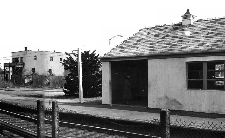
1. So we have vehicles behind the shelter that indicate 1957+ The station wagon behind the sign, perhaps 1960+? (Chevy 57 at far right)
2. Appears we have a turnout branching left (where the person is) photo center.
3. The siding/branch is in front of the truck and station wagon behind the shelter AND has a crossing gate to protect, just left of truck.
4. Looking at the shadows (it is Winter) it seems this is an afternoon photo view E
5. The photo indicates electrification double track.

Best, Steve :-)
 #1475189  by MattAmity90
 
Looks like Oceanside, the power lines used to look like that (six on top, two on bottom). Now they are three on top two on bottom, the line curves in the background over a canal, and right around that corner is East Rockaway.
oceanside21.jpg
 #1475296  by nyandw
 
Reviewing Emery maps the curved siding across the road, with gate crossing, and near left curve in the photo rear just don't fit...
Perhaps this building may stir a memory OR it may still exist!

http://www.trainsarefun.com/lirr/temp/Weber-zoom.jpg" onclick="window.open(this.href);return false;

Too bad I can't post the photo, just the link, but the pixel image error still exists with no input from railroad.net... :-(

Input I have received: It looks like the Long Beach or Far Rock branches. It can't be the West Hempstead branch as that was single track except at West Hempstead and this station is NOT West Hempstead. Thanks Folks.
 #1475305  by dieciduej
 
nyandw wrote:Reviewing Emery maps the curved siding across the road, with gate crossing, and near left curve in the photo rear just don't fit...
Perhaps this building may stir a memory OR it may still exist!

http://www.trainsarefun.com/lirr/temp/Weber-zoom.jpg" onclick="window.open(this.href);return false;

Too bad I can't post the photo, just the link, but the pixel image error still exists with no input from railroad.net... :-(

Input I have received: It looks like the Long Beach or Far Rock branches. It can't be the West Hempstead branch as that was single track except at West Hempstead and this station is NOT West Hempstead. Thanks Folks.
I was intrigued so I tried it myself. And I don't know the location.
Weber-zoom.jpg
Weber-zoom.jpg (466.74 KiB) Viewed 2972 times
JoeD
 #1475333  by MACTRAXX
 
Steve:

After looking again at Fred Weber's picture, Google Maps aerial view and my own experiences in
traveling around the LIRR electrified zone I think that this could be one of two locations:
Hewlett (looking westward towards Gibson-Far Rockaway Branch)
Copaigue (looking eastward towards Lindenhurst-old ground level station)
The vehicles and metal waiting shed visible help to date this picture during the 1960s.

Another problem with the photo is that the text on signs is not further readable. A good tip to
the location could be a posted phone number - which could be matched up with local exchanges.
Are there any other companion pictures that look like they were taken at the same location?

MACTRAXX
 #1475343  by MACTRAXX
 
SwingMan wrote:Sure looks like Oceanside, facing railroad west from the eastbound platform.
SM: I agree with you - the only other place that makes sense other then Hewlett or Copaigue
is Oceanside judging by the station area and roadways - and a left curve in the background visible.
I sometimes wonder why photographers do not further identify their pictures - but this is what can
make this subject just that much more interesting - the "where are we?" factor...MACTRAXX
 #1475358  by MattAmity90
 
Hewlett's low-level platforms were at the curve just past the current high-level platforms.

Copiague's low-level platforms with the curve would have the power lines on the left, and the lower tier in this photo has two wires when Copiague has always had four on the lowest tier. Plus Strong Avenue is past the curve, there is a grade crossing in the background not too far from where the photographer is. Copiague only had two grade crossings: Strong Avenue past the curve, and Great Neck Road at the West end of the platforms.

I'm sticking to Oceanside with my skill of identifying locations by memory. Just past that curve is East Rockaway, and even though you can't see it, it goes over a small canal before the curve.
 #1475390  by nyandw
 
MACTRAXX wrote:Steve: After looking again at Fred Weber's picture, Google Maps aerial view and my own experiences in
traveling around the LIRR electrified zone I think that this could be one of two locations:Hewlett (looking westward towards Gibson-Far Rockaway Branch)
Copaigue (looking eastward towards Lindenhurst-old ground level station)The vehicles and metal waiting shed visible help to date this picture during the 1960s.

Another problem with the photo is that the text on signs is not further readable. A good tip to the location could be a posted phone number - which could be matched up with local exchanges.Are there any other companion pictures that look like they were taken at the same location?MACTRAXX
Yes! Received them last evening. First, the shed has Oceanside Press as the sign and the other Fred Weber photos 3/29/1960 that show the 2nd station clearly at Oceanside! I also posted the Emery maps of the area: http://www.trainsarefun.com/lirr/longbe ... branch.htm
Here's the station:
http://www.trainsarefun.com/lirr/longbe ... rrison.jpg" onclick="window.open(this.href);return false;

My thanks to all that helped with this one! Nice. :-)

P.S. "...I sometimes wonder why photographers do not further identify their pictures - but this is what can
make this subject just that much more interesting - the "where are we?" factor...MACTRAXX...."
Well put, and an ongoing issue today with digital file names of Di002x0001.jpg!
 #1475432  by nyandw
 
Oceanside-Station_ViewSW_3-29-1960_Weber-Morrison.jpg
nyandw wrote:
MACTRAXX wrote:Steve: After looking again at Fred Weber's picture, Google Maps aerial view and my own experiences in
traveling around the LIRR electrified zone I think that this could be one of two locations:Hewlett (looking westward towards Gibson-Far Rockaway Branch)
Copaigue (looking eastward towards Lindenhurst-old ground level station)The vehicles and metal waiting shed visible help to date this picture during the 1960s.

Another problem with the photo is that the text on signs is not further readable. A good tip to the location could be a posted phone number - which could be matched up with local exchanges.Are there any other companion pictures that look like they were taken at the same location?MACTRAXX
Yes! Received them last evening. First, the shed has Oceanside Press as the sign and the other Fred Weber photos 3/29/1960 that show the 2nd station clearly at Oceanside! I also posted the Emery maps of the area: http://www.trainsarefun.com/lirr/longbe ... branch.htm
Here's the station:
http://www.trainsarefun.com/lirr/longbe ... rrison.jpg" onclick="window.open(this.href);return false;

My thanks to all that helped with this one! Nice. :-)

P.S. "...I sometimes wonder why photographers do not further identify their pictures - but this is what can
make this subject just that much more interesting - the "where are we?" factor...MACTRAXX...."
Well put, and an ongoing issue today with digital file names of Di002x0001.jpg!