Yes, they are starting to survey the area. Be interesting where they lay out the path considering how uneven the land is. Wish I usually lived local as I would like to see what they dig up in a few areas of interesest to me.
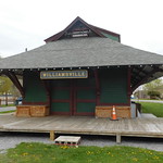
I had the great idea of doing collaborative historical markers with a good history for the railway and local surrounding area history. But talked to a guy who said it is already in the works. I will try to find out more and get some contacts and post if anyone is interested here.
Knowing how limited the knowledge is, and the scarcity of resources to research it easily, the project could use more people. I immodestly am probably the world's greatest living expert on the area of the town in question, but I certainly only know a fraction of the history. Not to mention the trail will be going through other areas of Tonawanda. The project could definitely use a few local area railroad gurus as the people I know who will be involved including myself are certainly not to the best of my knowledge.