by Benjamin Maggi
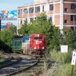
One of the areas I want to model on my layout is section of Cohoes from the bridge over the Mohawk River south to Mohawk Street. The time frame I picture for this portion of my layout is around 1984-1986. To give you a sense of what it might look like, the area here was still double tracked with a spur off the east track heading south towards the area that is now covered with "Tri-City Radiology." The track for Star Warehouse just south of the bridge still existed too but the switch was removed. The area was still be developed and new buildings (like the Burger King and an Apartment complex) were not in yet, and the Radiology place was just going up though it probably wasn't a radiology place back then).
The Cohoes Library is a great building to model as it almost looks like a stone castle. I imagine that it was originally built as a church.

The Cohoes Passenger Station is an area I would like more information on. When did it offically stop serving as a passenger station, and what year was it sold or leased to the public? Currently it is being used as an OTB but even in 1984 it was boarded up and surrounded by a fence.

Also, does anyone know when the D&H realligned their mainline and took the western track out of service? By 1986 it was long gone and covered in grass, but there was still a double track area (I am guessing the D&H was triple tracked here at one time?) Was this part of the bridge-reallignment plan that occured, because then and now the Eastern bridge of the two is used over the Mohawk.
Thanks for any help you can provide.
The Cohoes Library is a great building to model as it almost looks like a stone castle. I imagine that it was originally built as a church.
The Cohoes Passenger Station is an area I would like more information on. When did it offically stop serving as a passenger station, and what year was it sold or leased to the public? Currently it is being used as an OTB but even in 1984 it was boarded up and surrounded by a fence.
Also, does anyone know when the D&H realligned their mainline and took the western track out of service? By 1986 it was long gone and covered in grass, but there was still a double track area (I am guessing the D&H was triple tracked here at one time?) Was this part of the bridge-reallignment plan that occured, because then and now the Eastern bridge of the two is used over the Mohawk.
Thanks for any help you can provide.
Benjamin L. Maggi
A&A Railroad Forum Moderator
A&A Railroad Forum Moderator