• Rail Line near Minersville?

  • Pertaining to all railroading subjects, past and present, in Pennsylvania
Pertaining to all railroading subjects, past and present, in Pennsylvania

Moderator: bwparker1

  by lvrr325
 
Picked up an older Delorme PA Atlas last weekend and happened to notice just east of Minersville, and south of Mount Carmel, a line passing through small towns of Good Spring and Keller (Keffers) - where it seems to cross from one mountain to another via an S-shaped double horse-shoe curve, about a mile across. Not far from I-81, either, it crosses the line east of the curves. Further west it appears to also have a switchback, marked Williams Valley Jct. on one end, although who knows if they've just left out things or not. It's marked in some spots Conrail and some Abandoned. Presume it's Reading or PRR heritage. Wondered what it is and if it's still there? Seems like it would be fascinating to look at. A road is shown crossing the line three times through the S-curve (SR 4011), so it was accessable.

As it passes west it seems to go through Tower City, Williamstown, Lykens, and eventually coming out at Millersburg on the Susquehanna River. To the east it appears to go to Tremont, then lines go in two directions, one eastward to Minersville and one southward through Pine Grove and more or less parallelling I-81 from there.

Closest I-81 exit for this curve is for US 209.
  by Heidelbergbreaker
 
The area I am familiar with is the portion from Keffers Mountain west to Lykens that had a switchback. It is a Reading line and actually ended at a station near Market St. in Lykens. It may have been proposed to extend further west but actually ended in Lykens. From what long time residents tell me the station was demolished after the 1972 flood. At one time a lot of coal was shipped from the Lykens and Williams Valleys by both the Reading and the Pennsylvania. The Reading line passed under the Pennsylvania line at the present site of the Dauphin County Library on Arch St. in Lykens. While the Pennsylvania ( ex Summit Branch RR ) ROW is proposed to be part of a rail trail the Reading line has been developed by the adjoining property owners. A close friend actually purchased the portion of ROW running through his property. In an area where there were a lot of anthracite mines following the former lines can be confusing. There is a company in Lykens that manufactures heat exchangers that at one time may have been served by the Reading as the ROW passes near their property. You can still see portions of the rail bed along Rt. 209 when travelling from Lykens to Williamstown. The ROW on Keffers Mountain is on private property and is posted to tresspassers.
  by pumpers
 
Old topo maps at http://historical.mytopo.com/quad.cfm?q ... &series=15 (click on the "Southeast" portion of the map) in 1893 show the Reading coming from the east from Good Spring and ending about 1/2 mile north of Tower City, on the mountainside (at Brookside Station), and the Summit Branch RR (future PRR) coming in from the west ending 1/2 north of Williamstown, both presumably at coal mines. They ended with about a one mile gap between them at about the same elevation, but there is no suggestion they connected.
The 1955 maps show the switchback on the Reading, beginning at Williamston Jct (a location I see labeled on more modern topos) in the location of Brookside, going down into the valley and then Tower City, Williamstown and Lykens. I don't know if the Reading and PRR interchanged there or not. Here is a Reading system map, showing it ended at Lykens, with the a line from another company (the PRR) continuing to Millersburg. http://mappery.com/map-of/Reading-Railroad-System-Map
FWIW, the ex-Reading to Good Spring is still operated by the Reading and Northern http://www.readingnorthern.com/map.shtml.
JS
  by lvrr325
 
I only assumed the two connected because the map is so inconsistent; for whatever reason the rail lines are harder to see than normal. Too bad that double horseshoe is gone -
  by Schuylkill Valley
 
This line your talking about was known as the Schuylkill and Susquehanna Branch.
It was incorporated as the Dauphin & Susquehanna Coal Company on April 5, 1826, the mining company built a rail line westward in 1851 from Cold Spring to Dauphin, a distance of 18.3 miles. In 1854 the line was extended eastward to Auburn to connect to the Reading's Pottsville Line.

In 1854 the Dauphin & Susquehanna railroad Company went into receivership and reorganized as the Schuylkill and Susquehanna Railroad Company at which time the Allentown Railroad Company controlled the capital stock. The Philadelphia & Reading leased the in 1860 and purchased the stocks of both the Schuylkill & Susquehanna and the Allentown Railroad companies in 1861.

It was merged into the P&R on June 12, 1873. The line never really materialized substantial profits and in the mid - 1930's it was torn up for scrap.

Stations along this line were.
Cold Springs
Rattling Run
Quarry Siding
Water Tank
Locust Siding
White Springs
Ellendale Fordge
Walkemayers Siding
Stone Glen
Dauphin
Hecks
Rockville
Harrisburg.

Hope that helps,
Len.
  by pumpers
 
Actually, I think the line we are talking about is about 2 valleys to the north of the Schuylkill and Susquehanna. See the topo I linked above in my earlier post. You can see the S&S at the bottom -- we are talking about the line further up which went through Brookside, which was extended with a switchback to go to Tower City and then Williamstown and Lykens. The PRR then went from Lykens to Millersburg. JS
  by Schuylkill Valley
 
Well this is what I found in an old Pennsylvania Magazine from March 1987.

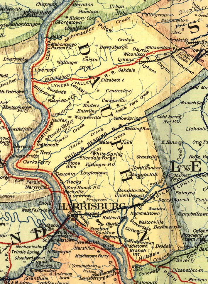
The original Lykens Valley Railroad was first constructed around 1834. It was used to haul coal to the Wiconisco Canal in Millersburg, and from there to the Pennsylvania Canal. The PRR owned collieries in Wiconisco in the late 1800's, as did the RDG. The RDG came over the mountains to the east via Pine Grove, Tremont and Tower City - while the PRR used the LVRR to haul the coal from Lykens/Wiconisco and Williamstown to the Northern Central RR in Millersburg, which by this time ran from Harrisburg to Sunbury on the east shore of the Susquehanna River. There are three railroad right of ways on the Broad Mountain from Wiconisco east to Williamstown and on to Tower City.

The Lykens Valley Railroad was built sixteen miles, from Bear Creek Gap to the Susquehanna, and was in operation in 1834, transporting the coal by horse-power over the flat strap-rail. The cars were carried across the Susquehanna on "arks", the coal dumped into chutes on the canal, loaded on the canal boats and transported to the various markets. This was the fourth railroad in the country and the first in Dauphin county, to transport anthracite coal. "The first canal boat load of Lykens Valley coals, now so famous, was sent April 19, 1834, by Boat No. 76, forty-three tons

In 1856 the Pennsylvania Railroad Company took control of the line and replaced the rail with t-rail. In 1856 the Susquehanna Division of the Northern Central Railway completed a line from Dauphin to Millersburg which meant that coal would be shipped by rail instead of boat.

The Summit Branch Railroad was built in 1866 from a point near Lykens to the Williamstown Colliery. The Lykens Valley Railroad extended to Williamstown and was leased to the Summit Branch Railroad. It was operated until 1880 when it was placed in the hands of the Northern Central Railway. The railroad branched in to freight and passenger service. In 1928 the steam train to Harrisburg was replaced by a gasoline-electric train. Passenger service was discontinued in 1937.

In the 1970's the tracks were torn up from Lykens to just before Elizabethville. Then the tracks were eventually torn up from Elizabethville down to Millersburg.


Image

This is copied from this book; American Railroad Manual for the United States
SUMMIT BRANCH RAILROAD COMPANY.
This company was practically incorporated to operate the Lykens Valley Railroad, running from Millersburg to Williamstown, a distance of 20 miles. The only portion of road owned by the Summit Branch Railroad Company is a short line, Six mile long, from Summit mines to a junction with the Lykens Valley Railroad. The capital stock authorized by law is $2,750,000, of which $2,502,250 have been subscribed and actually paid in. There is also a funded debt, 6 per cent, first mortgage bonds, maturing July 1, 1875, $145,000; and the total liabilities of the company, as represented by stock and debt, are $2,647,250. The cost of road and equipment, including Lykens Valley Railroad lease, is quoted as $988,902.37, and in addition the company owns real estate valued at $1,500,000; so that the total value of properly may be estimated as $2,488,902.37. The company owns 7 locomotives, 2 passenger cars, and 5 baggage, mail, and express cars ; and the cars for the transportation of coal are furnished by the parties operating the mines and by the Northern Central Railway Company. Earnings for fiscal year ending November 30, 1872, amounted to $322,986, derived from the following sources : from passengers, $8279.34; from freight, $291,458.44; from miscellaneous sources, $23,248.22. Expenses for the same period were $76,040.43, distributed as follows: for maintenance of way and structures, $27,336.76; for locomotive repairs, $5,853.31; for car repairs, $896; for conducting transportation, $38,682.05; for general expenses, $3272.31. Net earnings were $246,945.57, out of which was paid rental dividends at the rate of 6 per cent, upon the share capital, interest on the bonds and taxes.

LYKENS VALLEY RAILROAD COMPANY.
This company built a road from Millersburg to Williamstown, a distance of 20 miles, and in April, 1866, leased its property to the Summit Branch Railroad Company, with the understanding that the lessees should pay as rental (free from all taxes and assessments other than the United States income tax) $62,500. It was also provided that any improvements made upon the leased property by the lessees during the continuance of the lease should be deemed and considered the property of the lessors, without compensation therefor to the lessees. During the past six years the lessees have made considerable permanent improvements and additions to the property, so that the present cost of construction and value of the road is considerably in excess of what it was when the lease was made. The capital stock of the Lykens Valley Railroad Company is returned as $600,000, on which 10 per cent, dividends in quarterly payments are regularly declared.


Hope this helps,
Len.
  by GP30 5513
 
lvrr325 wrote:Picked up an older Delorme PA Atlas last weekend and happened to notice just east of Minersville, and south of Mount Carmel, a line passing through small towns of Good Spring and Keller (Keffers) - where it seems to cross from one mountain to another via an S-shaped double horse-shoe curve, about a mile across. Not far from I-81, either, it crosses the line east of the curves. Further west it appears to also have a switchback, marked Williams Valley Jct. on one end, although who knows if they've just left out things or not. It's marked in some spots Conrail and some Abandoned. Presume it's Reading or PRR heritage. Wondered what it is and if it's still there? Seems like it would be fascinating to look at. A road is shown crossing the line three times through the S-curve (SR 4011), so it was accessable.

As it passes west it seems to go through Tower City, Williamstown, Lykens, and eventually coming out at Millersburg on the Susquehanna River. To the east it appears to go to Tremont, then lines go in two directions, one eastward to Minersville and one southward through Pine Grove and more or less parallelling I-81 from there.

Closest I-81 exit for this curve is for US 209.
As previously stated, it was a Reading branch. While the horseshoes are gone, a portion of the ROW can be walked down the south side of Keffer's Mountain to Williams Valley JCT (which is now State Game Lands #264); A small baseball field's driveway (Archery Club Road) also uses the ROW in Keffers. The road that would've had three grade crossings when the line was active is Main Street, connecting Keffers with Good Spring. All three grade crossing areas still have visible remnants of the ROW, the with one beside a small business (Dyno) being the most difficult to seek out. The crossing in Good Spring is still used by the RBMN, as they use a short siding between Main Street & West Center Street for car storage. The Reading signal that presided over that junction at Good Spring still stands today, though it has no signal equipment left attached. And there still are railroad ties in the ground where the tracks split, leading into the first horseshoe.

The line that paralleled present day I-81 through North Pine Grove was the Lebanon & Tremont Branch of the Reading. Neither stations for Pine Grove and North Pine Grove exist there, though I seem to recall reading the NPG station being moved elsewhere in PA. If you've ever traveled that area, the large billboard opposite the busing company sits on the ROW.
  by Schuylkill Valley
 
This is the only Reading Company blue print I have on the Lebanon & Tremont Branch, this is Pine Grove, PA. from August 12, 1912
Photo one through Photo Six is all scanned in order as the print is layed out.
Hope you enjoy,
Len.
Image

Image

Image

Image

Image

Image
  by CliveArmstrong
 
I have a letter written by an ancestor(Philip Condon) in 1854, and it mentions his work on a railway near Minersville. Could anybody pinpoint which branch he may have been working on? A transcript of the letter is below. I have a copy of the original if anybody is interested.
Thanks
Clive

Tuesday Jan 17th 1854

Dear Sister

I send these few lines to you and hope to find

and ... in good health. I am fast recovering my

health and getting quite strong again thank god

for it. I have suffered great in Body since I came

home from Panama being six months in hospital, but not

so much in body as in (missing one line) and

children now 12 months it seems to me as if they had

quite forgot me it is an old saying and a true one that

Absence makes the heart grow fonder but it do not seem

so with Catherine or else she would have answered

some of the letters that I sent her. Mr. McGuire sent

2 letters while while I was in Hospital in new york and

I sent 2 since I have been in Hospital in

philadelphia and received no answer, but I mean

to return early in the summer and know the

reason is if I work (illegible and missing). I hope you

will be so kind as to answer this letter. I am at

work about 3 miles from a place called minersville

on the top of very high mountains on a railroad at

4s.-6d. per day but the winter been so severe

out here the we cannot make no more than

3 or 4 days a week, but it is very healthy about

here and I was advised by the doctor to

go their for the good of my health which

I am regaining quite fast. Panama was quite

a sickly place six hundred rail road ......

3 months ... I ......

Page2

Give my kind love to Catharine and the dear

children and to mother yourself and Husband

William, and Ann and husband and Children

Uncle Dwyer James and wife and child

Edmund wife and Child and Hope that

thay are well and in good health give my Regards

to Eliza and husband and all inquiring friends

So no more at present from your

affectionate Brother

Philip Condon

P.S. please direct to Philip James Condon Minersville

Schuylkill County in the estate of Pennsylvania

to be left in the post office until called for. Let me

know if James heard from that gentelman that

left London for Boston or whetherhe arrived safe their

for John Clarke sen me word last march that he had not

arrived their and he advised me not to go to Boston then has every thing was

so dull then that was the reason I went to Panama instead of going their

as James advised me.
  by pumpers
 
Check out this topo map from 1892. http://historical.mytopo.com/quad.cfm?q ... &series=15 Click on "northeast" to get the right section of the map. THere is a branch of the Reading RR (Mine Hill and Schuylkill Haven) that ran north and slightly east of Minersville (just going off the map), and then turned back west around Mine Hill, turning around again at Glen Carbon to go over Broad mountain, eventually to Gordon in the Mahanoy valley (actually, coal came the other way - it came up a series of planes from Gordon to high on Broad Mountain, then ran downhill by gravity to Minersville. I think it was orginally built to get coal to a canal on the Schuylkill, and was later an all rail route. Maybe your relation worked at the top of the plane.

Anyway, Mine Hill and Broad Mountain are about 2 or 3 miles from Minersville. I'm just assuming it was there in 1854 already -- that sounds about right but someone else will probably know for sure. (Look on the "Southeast" part of the map for the length scale at the bottom). And it might not have been part of the Reading yet in 1854. (and there are probably other RR lines high up in that area....). This line going north a bit out of Minersville (before the turn to the west) down to connect to other Reading lines still active in coal country is still operated (or was until recently) by the Reading and Northern RR http://www.readingnorthern.com/map.shtml

JS
  by GP30 5513
 
I walked some of the 'open' portion of the branch first mentioned in this thread on New Years Eve. While I won't be posting every shot I took, this one I will. I pointed the camera south in Keffers at the site of where the line would've had a grade crossing on Main Street. Behind me would be Archery Club Road, part of the ROW. You can clearly see where the ROW bears to the right on its way to Williams Valley Junction. The tree on the left growing out of the ground surrounded by concrete block is the foundation of the former Reading Keffers Station. I'm not sure if those two nominally spaced cracks across Main Street give an indication if there still is rail beneath the pavement.

Image

Enjoy.
  by choess
 
Clive,

Your description matches with the construction of the Mine Hill & Schuylkill Haven Railroad's extension from Minersville north and west through Coal Castle and Glen Carbon to the Gordon Planes in 1854.