by JJMDiMunno
Hey everyone,
Long message warning...this one goes on for quite a while...
Well first off tonight, I'd like to say that those that passed up on this trip to North Jersey today with Dave Halbert, Jay O, and I really missed out on something good. We couldn't have asked for better weather as the rain from the day before left town and sunshine and nice temperatures moved in for the entire day. Here's the details of our trip for June 12th:
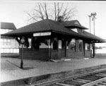
We started out heading north on I295, with the intention of hopping on route 31 to head straight up to Phillipsburg and the Bel-Del steam excursion. This didn't work out. We actually ended up on route 29 north out of Trenton, which turned out to be a better route in the long run as there was much to see along the way. This road parallels the abandoned PRR Bel-Del route for most of the distance to Milford, where the in-service track operated by the BDRY begins. The first place we stopped on the way was the Stockton railroad station, which we actually found quite by accident (weren't really expecting a station here). This building can be seen below, along the hiking trail:
http://members.aol.com/jjmdimunno/Stockton.jpg
Next up was the Frenchtown station, very similar to the Stockton one:
http://members.aol.com/jjmdimunno/Frenchtown.jpg
Railroad service over the Bel-Del picks up at Milford, which is operated by the BDRY. We walked around Milford for a while and discovered many historical artifacts, and determined that at one time, there may have been as many as 4 tracks in some spots around there. I'm particularly curious as to what the layout looked like years ago, if anyone happens to have a track diagram for this station area, I'd be dying to see it. Here's today's digital of the station building:
http://members.aol.com/jjmdimunno/Milford.jpg
One of the artifacts we found at Milford was this old railroad booth in decent condition (despite the leaning of the structure):
http://members.aol.com/jjmdimunno/Milford_Booth.jpg
After we were finished with Milford, we continued to parallel the Bel-Del until we reached Phillipsburg, the location of the recently heavily-advertised steam excursions. The trip took about 40 minutes total, and moved along at a nice leisurely pace, allowing the alert historian to see the many artifacts that can be viewed along the line (in addition to noting how many tracks this route actually contained in some spots at one time). Upon our arrival back at Phillipsburg behind the 2-8-2, I shot the locomotive being prepared for it's next trip to Carpentersville:
http://members.aol.com/jjmdimunno/Susquehanna_142.jpg
After the ride, it was time for the first Wawa stop of the day (very important), and after we purchased our lunch, we went to eat it at a location along the Lehigh Line over by CP EASTON. Luckily for us, an autorack went rolling by during our lunch break (though I have no idea what the symbol on this was). This was one of only two trains that we saw or heard in several hours around the Lehigh Line today (I had expected more, but it wasn't meant to be). It can be viewed near CP EASTON below:
http://members.aol.com/jjmdimunno/Autorack_Easton.jpg
After lunch, we proceeded to follow the Bel-Del route out of Phillipsburg up towards Belvidere. Upon our arrival at Belvidere, we went for a little hike along the Ex-Lehigh and Hudson River railroad (abandoned by Conrail, anyone have an exact year for this?), to the location of G Tower (the spot where the PRR Bel-Del and the L&HR split). Along the way, besides the fact that the main is still in place, there are many artifacts that can be seen, including but not limited to this milepost marker, still proudly displaying the number "72":
http://members.aol.com/jjmdimunno/LHR_MP72.jpg
Finally, after a decent walk, we arrived at the junction of the PRR and the L&HR. G-tower is obviously long gone, but the foundation can still be easily found and is in good shape for it's age. Here, we see the foundation alongside the Bel-Del:
http://members.aol.com/jjmdimunno/GTower_Foundation.jpg
And here, we have an overview of the junction facing east (the L&HR is on the right, the Bel-Del is on the left):
http://members.aol.com/jjmdimunno/GTower.jpg
Compare with the following image from http://www.thebluecomet.com , from 1965 (this view shows G tower and all):
http://www.thebluecomet.com/pcGtowerBelv65.jpg
Now, someone please tell me, what's the deal with the heavy (140 lb) welded rail on the first several hundred feet of the L&HR? The Bel-Del isn't welded at all at this point, and that's still in service...the L&HR is welded here and has been out of service since the early days of Conrail. Also, I have a few more questions. What was the official Conrail name for the Lehigh and Hudson River Line that they took over? I'm speaking of the line that comes off the Bel-Del at G-tower. I am aware that the Bel-Del was called the "Delaware Secondary" or "Delaware Branch" or something like that, but that's not the point here right now, I'm looking for this line's name.
After we were finished with the L&HR down by G tower, we hiked back to the SUV and while we were getting ready to leave, we noticed that a building within the confines of AmeriGas (the last customer on the L&HR before abandonment) looked an awful lot like a station. It was determined that the building seen below, within the confines of AmeriGas, is the Mansfield Street station from the L&HR (This was the L&HR's Belvidere station, it was called Mansfield Street to avoid confusion with the PRR Belvidere station):
http://members.aol.com/LHR_Mansfield_Street.jpg
Next, we proceeded along the L&HR to the relatively well preserved Great Meadows station complex. The buildings appear to be in need of some work at this time though, and I was informed that the condition has gone downhill since a few years back, when David was there last. The image below shows the complex as seen today (there are actually still rails by this station...you can't see them here due to the brush, but they're there):
http://members.aol.com/jjmdimunno/LHR_Great_Meadows.jpg
Now, compare the image above with one from http://www.gingerb.com , of the Great Meadows station when it was still in service back in 1960:
http://www.gingerb.com/L&HR%20Great%20M ... 201960.jpg
After we were done there at Great Meadows, we moved on to the freight station at Allumuchy. This station had somewhat of a story behind it, as reportedly there was a 73-car siding there that had been used to hold a presidential train back during World War II, while the president visited a female friend in the area. The freight house is still standing, and rail remains buried beneath the road at this location and in some spots around the station. Here's a view of the building as it stands now:
http://members.aol.com/jjmdimunno/Allum ... tHouse.jpg
And once again, let's compare with an image from http://www.gibgerb.com from the year 1963:
http://www.gingerb.com/L&HR%20Allamuchy ... 201963.jpg
This marks the end of our adventure with the Lehigh and Hudson River Railroad (well, temporarily). After this stop, we moved on to try to catch a few glimpses of the great Lackawanna CutOff. And glance at it we did...the first stop was the Johnsonburg Station, one of the Lackawanna's concrete structures built to stand against the test of time. The fact that this building is still intact just goes to show how well it was constructed:
http://members.aol.com/jjmdimunno/Cutof ... onburg.jpg
I don't know what that is on the lens, might have been a bug or something...
Following the stop at Johnsonburg, we moved on to what I considered the highlight of the day, something which I had never seen before, the Lackawanna CutOff's Paulins Kill viaduct. What a structure that is...and I'm telling you, anyone that hasn't seen this yet MUST find some way to see it in person. THis photograph simply does not do it justice, but should be able to give everyone who hasn't seen this in person some idea of the sheer size of the bridge (foliage at this time of year prevented me from getting a complete shot of the bridge, as it is MUCH larger than you can see here...this is half of one arch, of which there are many):
http://members.aol.com/jjmdimunno/Cutof ... nsKill.jpg
We walked around for a little while by the viaduct, hiking along the old Delaware Lackawanna and Western and Lehigh and New England ROW's beneath the span. After we were finished here, we started back south to head home, but not without one more surprise stop.
Many years ago, there was a junction located at Andover, NJ, which was where the Lehigh and Hudson River "Sussex Branch" crossed and connected with the Delaware Lackawanna and Western. Some of the L&HR ROW has been obliterated now due to the construction of a parking lot on some of the ROW, but there's a surprise lurking in the woods. Still standing guard over the old 90 degree diamond that stood in place at Andover is this Lehigh and Hudson River signal:
http://members.aol.com/jjmdimunno/Andov ... Signal.jpg
That about concludes today's trip documentation folks. For those that didn't come along, once again, you missed a great day.
And oh yeah, I've got one more thing to say. Whoever says that New Jersey is just a bunch of asphault with no scenery whatsoever is nuts:
http://members.aol.com/jjmdimunno/Scenic_NJ.jpg
That ladies and gentlemen is the Delaware River up by Frenchtown...not too bad...
David and I are planning more excursions for the time that he is up here, details will be announced as soon as we figure them all out ourselves. After seeing this report, I hope that some others will seriously consider coming along. I'm sure Jay will agree with me when I say that a historical trip with David is like nothing else in existance...
Take care everyone.
Mike DiMunno
www.SJRail.com: All about South Jersey Railroads!
Long message warning...this one goes on for quite a while...
Well first off tonight, I'd like to say that those that passed up on this trip to North Jersey today with Dave Halbert, Jay O, and I really missed out on something good. We couldn't have asked for better weather as the rain from the day before left town and sunshine and nice temperatures moved in for the entire day. Here's the details of our trip for June 12th:
We started out heading north on I295, with the intention of hopping on route 31 to head straight up to Phillipsburg and the Bel-Del steam excursion. This didn't work out. We actually ended up on route 29 north out of Trenton, which turned out to be a better route in the long run as there was much to see along the way. This road parallels the abandoned PRR Bel-Del route for most of the distance to Milford, where the in-service track operated by the BDRY begins. The first place we stopped on the way was the Stockton railroad station, which we actually found quite by accident (weren't really expecting a station here). This building can be seen below, along the hiking trail:
http://members.aol.com/jjmdimunno/Stockton.jpg
Next up was the Frenchtown station, very similar to the Stockton one:
http://members.aol.com/jjmdimunno/Frenchtown.jpg
Railroad service over the Bel-Del picks up at Milford, which is operated by the BDRY. We walked around Milford for a while and discovered many historical artifacts, and determined that at one time, there may have been as many as 4 tracks in some spots around there. I'm particularly curious as to what the layout looked like years ago, if anyone happens to have a track diagram for this station area, I'd be dying to see it. Here's today's digital of the station building:
http://members.aol.com/jjmdimunno/Milford.jpg
One of the artifacts we found at Milford was this old railroad booth in decent condition (despite the leaning of the structure):
http://members.aol.com/jjmdimunno/Milford_Booth.jpg
After we were finished with Milford, we continued to parallel the Bel-Del until we reached Phillipsburg, the location of the recently heavily-advertised steam excursions. The trip took about 40 minutes total, and moved along at a nice leisurely pace, allowing the alert historian to see the many artifacts that can be viewed along the line (in addition to noting how many tracks this route actually contained in some spots at one time). Upon our arrival back at Phillipsburg behind the 2-8-2, I shot the locomotive being prepared for it's next trip to Carpentersville:
http://members.aol.com/jjmdimunno/Susquehanna_142.jpg
After the ride, it was time for the first Wawa stop of the day (very important), and after we purchased our lunch, we went to eat it at a location along the Lehigh Line over by CP EASTON. Luckily for us, an autorack went rolling by during our lunch break (though I have no idea what the symbol on this was). This was one of only two trains that we saw or heard in several hours around the Lehigh Line today (I had expected more, but it wasn't meant to be). It can be viewed near CP EASTON below:
http://members.aol.com/jjmdimunno/Autorack_Easton.jpg
After lunch, we proceeded to follow the Bel-Del route out of Phillipsburg up towards Belvidere. Upon our arrival at Belvidere, we went for a little hike along the Ex-Lehigh and Hudson River railroad (abandoned by Conrail, anyone have an exact year for this?), to the location of G Tower (the spot where the PRR Bel-Del and the L&HR split). Along the way, besides the fact that the main is still in place, there are many artifacts that can be seen, including but not limited to this milepost marker, still proudly displaying the number "72":
http://members.aol.com/jjmdimunno/LHR_MP72.jpg
Finally, after a decent walk, we arrived at the junction of the PRR and the L&HR. G-tower is obviously long gone, but the foundation can still be easily found and is in good shape for it's age. Here, we see the foundation alongside the Bel-Del:
http://members.aol.com/jjmdimunno/GTower_Foundation.jpg
And here, we have an overview of the junction facing east (the L&HR is on the right, the Bel-Del is on the left):
http://members.aol.com/jjmdimunno/GTower.jpg
Compare with the following image from http://www.thebluecomet.com , from 1965 (this view shows G tower and all):
http://www.thebluecomet.com/pcGtowerBelv65.jpg
Now, someone please tell me, what's the deal with the heavy (140 lb) welded rail on the first several hundred feet of the L&HR? The Bel-Del isn't welded at all at this point, and that's still in service...the L&HR is welded here and has been out of service since the early days of Conrail. Also, I have a few more questions. What was the official Conrail name for the Lehigh and Hudson River Line that they took over? I'm speaking of the line that comes off the Bel-Del at G-tower. I am aware that the Bel-Del was called the "Delaware Secondary" or "Delaware Branch" or something like that, but that's not the point here right now, I'm looking for this line's name.
After we were finished with the L&HR down by G tower, we hiked back to the SUV and while we were getting ready to leave, we noticed that a building within the confines of AmeriGas (the last customer on the L&HR before abandonment) looked an awful lot like a station. It was determined that the building seen below, within the confines of AmeriGas, is the Mansfield Street station from the L&HR (This was the L&HR's Belvidere station, it was called Mansfield Street to avoid confusion with the PRR Belvidere station):
http://members.aol.com/LHR_Mansfield_Street.jpg
Next, we proceeded along the L&HR to the relatively well preserved Great Meadows station complex. The buildings appear to be in need of some work at this time though, and I was informed that the condition has gone downhill since a few years back, when David was there last. The image below shows the complex as seen today (there are actually still rails by this station...you can't see them here due to the brush, but they're there):
http://members.aol.com/jjmdimunno/LHR_Great_Meadows.jpg
Now, compare the image above with one from http://www.gingerb.com , of the Great Meadows station when it was still in service back in 1960:
http://www.gingerb.com/L&HR%20Great%20M ... 201960.jpg
After we were done there at Great Meadows, we moved on to the freight station at Allumuchy. This station had somewhat of a story behind it, as reportedly there was a 73-car siding there that had been used to hold a presidential train back during World War II, while the president visited a female friend in the area. The freight house is still standing, and rail remains buried beneath the road at this location and in some spots around the station. Here's a view of the building as it stands now:
http://members.aol.com/jjmdimunno/Allum ... tHouse.jpg
And once again, let's compare with an image from http://www.gibgerb.com from the year 1963:
http://www.gingerb.com/L&HR%20Allamuchy ... 201963.jpg
This marks the end of our adventure with the Lehigh and Hudson River Railroad (well, temporarily). After this stop, we moved on to try to catch a few glimpses of the great Lackawanna CutOff. And glance at it we did...the first stop was the Johnsonburg Station, one of the Lackawanna's concrete structures built to stand against the test of time. The fact that this building is still intact just goes to show how well it was constructed:
http://members.aol.com/jjmdimunno/Cutof ... onburg.jpg
I don't know what that is on the lens, might have been a bug or something...
Following the stop at Johnsonburg, we moved on to what I considered the highlight of the day, something which I had never seen before, the Lackawanna CutOff's Paulins Kill viaduct. What a structure that is...and I'm telling you, anyone that hasn't seen this yet MUST find some way to see it in person. THis photograph simply does not do it justice, but should be able to give everyone who hasn't seen this in person some idea of the sheer size of the bridge (foliage at this time of year prevented me from getting a complete shot of the bridge, as it is MUCH larger than you can see here...this is half of one arch, of which there are many):
http://members.aol.com/jjmdimunno/Cutof ... nsKill.jpg
We walked around for a little while by the viaduct, hiking along the old Delaware Lackawanna and Western and Lehigh and New England ROW's beneath the span. After we were finished here, we started back south to head home, but not without one more surprise stop.
Many years ago, there was a junction located at Andover, NJ, which was where the Lehigh and Hudson River "Sussex Branch" crossed and connected with the Delaware Lackawanna and Western. Some of the L&HR ROW has been obliterated now due to the construction of a parking lot on some of the ROW, but there's a surprise lurking in the woods. Still standing guard over the old 90 degree diamond that stood in place at Andover is this Lehigh and Hudson River signal:
http://members.aol.com/jjmdimunno/Andov ... Signal.jpg
That about concludes today's trip documentation folks. For those that didn't come along, once again, you missed a great day.
And oh yeah, I've got one more thing to say. Whoever says that New Jersey is just a bunch of asphault with no scenery whatsoever is nuts:
http://members.aol.com/jjmdimunno/Scenic_NJ.jpg
That ladies and gentlemen is the Delaware River up by Frenchtown...not too bad...
David and I are planning more excursions for the time that he is up here, details will be announced as soon as we figure them all out ourselves. After seeing this report, I hope that some others will seriously consider coming along. I'm sure Jay will agree with me when I say that a historical trip with David is like nothing else in existance...
Take care everyone.
Mike DiMunno
www.SJRail.com: All about South Jersey Railroads!
~Mike DiMunno
CSAO Beesley Point Secondary - MP 8.69 (Magnolia, NJ)
Moderator: Pennsylvania-Reading Seashore Lines :: Penn Central
CSAO Beesley Point Secondary - MP 8.69 (Magnolia, NJ)
Moderator: Pennsylvania-Reading Seashore Lines :: Penn Central
