Railroad Forums 

  • Sign, sign, everywhere a sign ...

  • Discussion relating to commuter rail, light rail, and subway operations of the MBTA.
Discussion relating to commuter rail, light rail, and subway operations of the MBTA.

Moderators: sery2831, CRail

 #1482214  by Yellowspoon
 
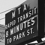
B train to GOV’T CENTER - Note that "B" and "GOV'T CENTER" both appear
000B.jpg
000B.jpg (30.94 KiB) Viewed 6234 times
A rather odd occurrence that I’d never seen before. The train was marked B GOV’T CENTER. First, of course, is that B trains normally terminate at Park Street. The second unusual thing was the train carried both the letter “B” and “GOV’T CENTER” designation. I had never seen a GC train that had also carried a letter designation. The third unusual thing was that when the train pulled into Government Center, the operator opened the doors on the right side of the train to let the passengers exit.

By now, you’ve guessed that this was a southbound train that originated at Lechmere. Why it only went as far as GC is for you to tell me because I have no idea.
 #1482443  by BigUglyCat
 
The EGE wrote:Because they're actually running to Blandford Street to turn at the pocket track there, I would guess.
That would have been a B with a red slash through it, for Blandford as you say. I recall seeing E slash destination signs on Huntington Avenue cars. I believe the practice began with the Boeing LRVs.
 #1482676  by Yellowspoon
 
It's a "B" because the trains always leave Kenmore onto Commonwealth Avenue. Think of "B" for Blandford.

As a side note, I once observed a gentleman ignore a Lechmere train at Park Street. When I asked him why he did not get on the train, he said that he was waiting for an "E" train. The good-for-nothing maps show "E" trains going to Lechmere but fail to mention that the eastbound trains do not carry letter designations.

Incidentally, after I alighted the "B - GOV'T CENTER" train, I caught an empty "C" train to continue my journey to Park Street. The C train had looped at GC. Unfortunately, the poor patrons who were waiting at Haymarket and North Station were not aware that they should have taken the "B" train to GC.

To use a quote from The Taking of Pelham 1-2-3, "What the hell did they expect for their lousy 35 cents"
Last edited by CRail on Mon Aug 13, 2018 2:40 pm, edited 1 time in total. Reason: Unnecessary quote removed.
 #1482679  by MBTA3247
 
Red Wing wrote:I haven't seen a slash since the roll signs disappeared.
That's because the craptastic LCD displays have neither the resolution nor the contrast to display a slash through a letter.
 #1482680  by CircusFreakGRITZ
 
Yellowspoon wrote:It's a "B" because the trains always leave Kenmore onto Commonwealth Avenue. Think of "B" for Blandford.
Well I know about the pocket track at Blandford. But what I find interesting is that even the Lechmere-Govt Center shuttles are signed as “B Govt Center” trains.
 #1482811  by CRail
 
It is not "B for Blandford," it's B for the Comm. Ave. line which westbound Kenmore trains use to turn. This notion that route letters simply abbreviate the destination names needs to be destroyed!

The signs are set up so that westbound cars have letters and eastbound cars do not. If the last train from Heath Street which only serves the surface signs up correctly at Heath St. ("Northeastern"), the sign shows Northeastern without the letter. If a car signs up for Northeastern from Lechmere, it will say "E Northeastern." The system knows the direction because it remembers the last location tag it read. I assume the letter for anywhere in the subway is B because the signs were supposed to work with the AVI setting (they do not) and the AVI for the Brattle loop is 820. 823 is also used as a route designation for BC cut ins (meaning the trip starts mid route, or "cuts in") using Chestnut Hill Ave, therefor it's recognized as a Comm. Ave. AVI setting (as is anything lower than 83X, which is Beacon St.). Again, the AVI and the signs do not communicate with eachother, but the people who programmed each probably did.
 #1500901  by Yellowspoon
 
GPAR_150413_18277.jpg
GPAR_150413_18277.jpg (25.87 KiB) Viewed 3735 times
Here is a sign at the Park Street inspector's booth. If one is at Park Street, where does one catch an "inbound" train?

On Friday, 15-Feb-19, I was on a red line train from Park to Alewife. At Charles, two middle-age ladies entered the train and they were staring at the cryptic map over the door. One of them pointed to "Charles" and then counted over three stops and told her partner that they had to go three stops. The only problem is that the first woman was pointing at "South Station" when she said she wanted to go three stops. I quickly interjected and indeed confirmed that they boarded the wrong train. You see, when they boarded the train at South Station to get to Charles, they boarded an "inbound" train. Logically, they assumed that to get back to South Station, they should board an "outbound" train. For the life of me, I can't figure out why the red line trains are not "north bound" or "south bound".

I informed the ladies that they had two choices: (A) Reverse direction at Kendall and pay a separate fare, or (B) go three stops and reverse direction at Harvard. They chose option (B).
 #1503252  by Yellowspoon
 
Here is a sign that I photographed in June, 2016. This was 2+ years after B trains terminated at Park Street and three months after GovCen re-opened. However, the sign indicates that B trains terminate at GovCen.
000Copley.jpg
000Copley.jpg (33.76 KiB) Viewed 3391 times
This post is about those two large arrows pointing down. It took me several minutes to figure out what they were for. But more to the point, how is a tourist going to know what they mean? This was the only sign on which I have noticed these large arrows pointing down.

Earlier this week, I noticed that the sign had now been replaced and that "B" trains were now shown to terminate at Park Street. However the arrows are not on the sign any more. What's changed?

As for the second sign, taken at Hynes: C'mon folks, Arborway closed 33 years ago. Occasionally, just for grins, I'll ask an MBTA employee where Arborway is. They usually don't know.
Attachments:
GHYN_ArborwasClosed.jpg
GHYN_ArborwasClosed.jpg (35.9 KiB) Viewed 3391 times
 #1503403  by CRail
 
I think this thread has run its course. It's not news that outdated signage survives on the system. Many of us who are history buffs enjoy seeing vestiges of the system that was. It would be one thing if this were a discussion about neat finds like surviving old yellow bus stops and even interesting or funny follies like "64 Oak Grove" (which actually existed and for those of you who aren't familiar, the 64 serves Oak Square), but it has been an ongoing gripe about the system and its employees who do not have any control over the matter. That's not the purpose of this forum.