Railroad Forums 

  • CNJ Southern Division

  • Discussion of the CNJ (aka the Jersey Central) and predecessors Elizabethtown and Somerville, and Somerville and Easton, for the period 1831 to its inclusion in ConRail in 1976. The historical society site is here: http://www.jcrhs.org/
Discussion of the CNJ (aka the Jersey Central) and predecessors Elizabethtown and Somerville, and Somerville and Easton, for the period 1831 to its inclusion in ConRail in 1976. The historical society site is here: http://www.jcrhs.org/

Moderator: CAR_FLOATER

 #84298  by pollard7545
 
I am looking for all of the stations and interlockings for the Southern Division that went towards Bridgeton. Does anyone have any information and/or timetables that I can use or post here? Thanks!
 #84435  by pollard7545
 
Here is the stations that I have for the Southern Division. Please feel free to give me the correct mileposts.
Red Bank(mp38)
Shrewsbury (39)
Eatontown(41)
Earle(48)
Farmingdale(50)
Maxim(53)
Lakewood(58)
South Lakewood(61)
Lakehurst(66)
Whitings(71)
Pasadena(76)
Woodmansie(79)
Chatsworth(84)
Pinecrest(87)
Garranza(90)
Atsion(95)
Parkdale(98)
Chew Road(99)
Elm(102)
Winslow Junction(104)
Winslow(105)
Collings Siding(108)
Cedar Lake(110)
Brimfield(111)
Landisville(115)
Minotola(115)
Wheat Road(117)
Main Avenue Station(118)
Vineland(120)
Norma(123)
Rosenhayn(126)
Woodruffs(129)
Bridgeton Junction(130)
Bridgeton(132)
East Bridgeton
Fairton
Cedarville
Newport
Penn
Dividing Creek
Whitehead
Mauricetown
Port Norris
Bivalve

Once again, thanks for any and all help!
 #84444  by pollard7545
 
Here are the stations to Bayside....I need the correct mileposts:
Bridgeton Junction
Bowentown
Sheppards Mill
Bacons Neck
Bayside
 #84459  by pollard7545
 
Here is the last part at Bridgeton Junction:
Bridgeton Junction
Orchard Center
Seabrook
Deerfield

Again, I need the proper mileposts.
Thanks again!!

 #84609  by Jtgshu
 
I don't have any off hand, but don't forget about the original mainline from Red Bank to Port Monmouth, abandoned in the early 20's i think.

I have a book I got at the CNJ fest about all the stations and structures on the CNJ, but its packed away somewehre, but if i can find it, ill see what it says, but i don't konw off hand if it has the Mileposts

 #84932  by pollard7545
 
OK, I managed to get a copy of a CNJ Timetable from 1968 that gave the following information:
Main Line-Southern Division
Red Bank (38.1)
Shrewsbury (39.9)
Eatontown (41.4)
Rosevelt (45.4)
East Earle (46.0)
West Earle (48.0)
Farmingdale (50.8)
Maxim (53.5)
Lakewood (58.0)
Sand Pit (61.0)
South Lakewood (63.0)
Lakehurst (65.9)
Whitings (71.7)
Chatsworth (84.3)
Atsion (95.5)
Winslow Jct (104.0)
Cedar Lake (110.0)
Landisville (115.0)
Wheat Road (117.0)
Main Avenue (118.2)
Vineland (120.1)
Norma (123.6)
Rosenhayn (125.9)
Woodruffs (129.0)
Bridgeton Jct (130.6)
Bridgeton (132.5)
Bowentown (134.9)

Cumberland & Maurice River Branch
Bridgeton Jct (0.0)
Fairton (5.23)
Cedarville (8.92)
Newport (11.42)
Penn (13.04)
Dividing Creek (14.45)
Whitehead (16.14)
Mauricetown (18.04)
 #85370  by 1st Barnegat
 
pollard7545:

Your mileposts match those from the CNJ Employee timetable of Apr 28, 1968: (Timetable No. 9)

CNJ ran through freight service Jersey City to Bridgeton Jct. in those days. Here are their schedules from CNJ Employee timetable of Apr 28, 1968:


Train JS 1 westbound (geographic south). Numbered as train 4291. Fourth class.

Jersey City 7:45 PM
E’port 9:30 PM
Lakehurst 1:01 AM
Winslow Jct. 2:15 AM
Bridgeton Jct. 4:30 AM

Train SJ 2 eastbound. Numbered as train 4292. Fourth class.

Bridgeton Jct. 9:00 PM
Winslow Jct. 11:20 PM
Lakehurst 12:35 AM
E’port 5:30 AM
Jersey City 6:00 AM

There was also another fourth class train that ran east out of Bridgeton Jct – train 4708. Its schedule was:

Bridgeton Jct. 8:00 AM
Rosenhayn 8:10 AM
Vineland 10:00 AM
Landisville 10:20 AM
Cedar Lake 10:30 AM
Winslow Jct. 10:45 AM

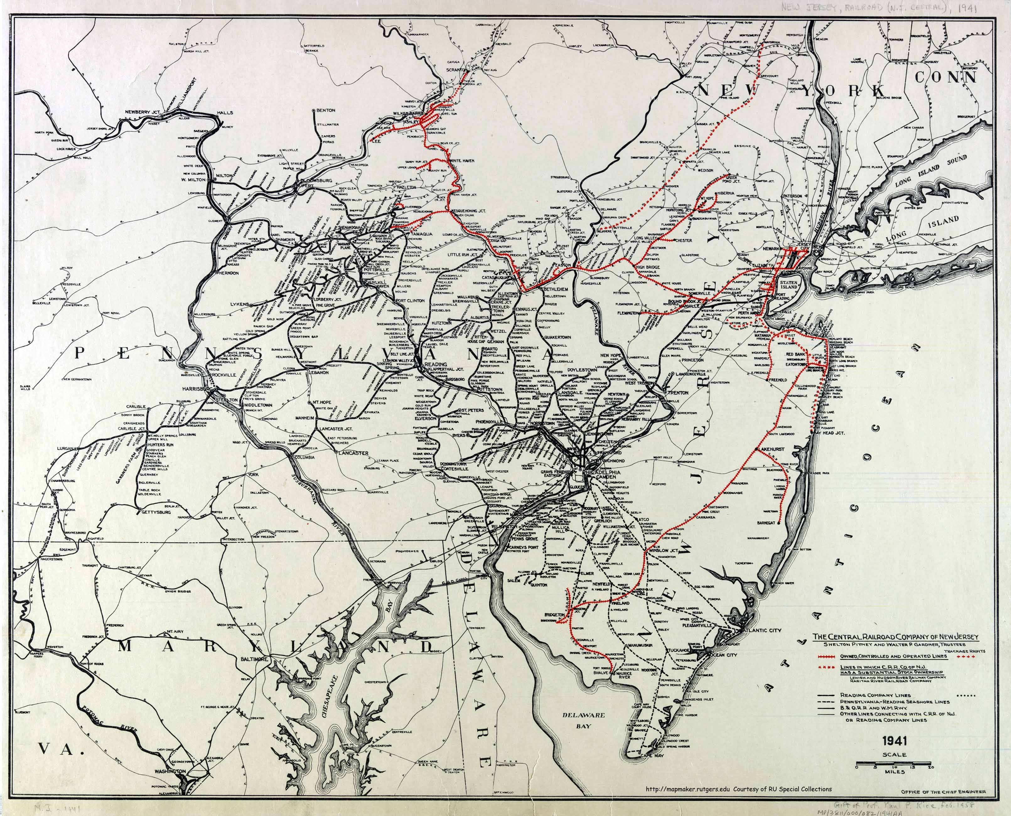
Local Freights ran out of Bridgeton Jct. toward Bridgeton and Mauricetown (map at http://mapmaker.rutgers.edu/HISTORICALM ... R_1941.jpg ). When headed down the Bridgeton branch the local freight was known as “First Bridgeton.”

Further north, another local freight ran out of Lakehurst, to cover the southern division towards Whitings and to cover the Barnegat Branch. When headed toward Barnegat it was known as “First Barnegat.”

Out of Red Bank, even further north, there was a local freight that ran down the Southern Division towards Lakewood and covered that division to just north of Lakehurst. It also ran on the NJCL and was known there as the Bradley Beach Turner.

Also out of Red Bank was a local that covered the Seashore Branch, and was known as QV 1 to Freehold.

JS 1 and SJ 2 ran until 1976 [edited Jan 13, 2005]. The locals to Barnegat and to Lakehurst were later combined by ConRail and run out of Browns Yard as a single train known as SA35. It now appears to be renamed as SA31, and exists today.

This site provides track diagrams for most of the Southern Division. http://raildata.railfan.net/cnj/homecnj.html

Octrainguy’s web site also provides information on the Southern Division: http://octrainguy.com/

So does Robert A. Staples' web site: http://www.thebluecomet.com/

More photos at NJ Vike’s page and Nykkis’ page at http://njpinelandsanddownjersey.com/photos/albums.php

Even more photos at Gerald Oliveto’s site: http://www.geocities.com/transit383/

Lastly, here’s a 1968 photo of SJ 2: http://forums.railfan.net/forums.cgi?bo ... Y_1968.jpg
Last edited by 1st Barnegat on Thu Jan 13, 2005 8:58 pm, edited 2 times in total.

 #86375  by njt4172
 
First Barneget,


Robert Staples site says that the JS1 and the SJ2 only ran until April of 1976..... Was his date wrong? According to you they ran a couple years after Conrail??

Thanks,
Steve

 #86470  by Jtgshu
 
Okay, I got my book from the CNJ fest - "historic Journey's by rail - Central Railroad of NJ, stations, structures and marine equipment" by Benjamin L. Bernhart

Unfortunately, it doesn't list mileposts, but does list when the stops were discontinued. It looks like you got most of them, but there are a few not listed.

Belford Branch - P. Monmouth to Red Bank - numbers after station name are when station was discontinuance/abandonment/destroyed

Port Monmouth Pier - abandoned 1871
Water Tank - abandoned 1883
Hopping (became Hopping Jct when the Seashore Branch was built)
Chapel Hill - approx 1916
Hedden - 1870
Red Bank - station was on Morford Place - demolished 1947

Red Bank to Bayside

Red Bank - (NY and LB station) - still existing and in use on Coast Line
Shrewsbury - fire 1950
Eatontown Junction - fire 1969
Shark River - 1954
New Bedford - 1863
Phoenix - 1896
Farmingdale - 1915
Squankum - 1889
Maxim (Hendricksons) - ?
Lakewood - 1953
Mounts - 1882
South Lakewood - destroyed by derailment 1964
Whites Bridge - 1893
Ridgeway - 1872
Lakehurst - 1962
Whitings - ?
Hydraulic - very early 20th century
Pasadena - 1937
Bullock (freight house) - 1920
Woodmansie - 1937
Lebanon - 1867
Chatsworth - 1952
Pine Crest - 1938
Carranza - 1938
Hampton (Ryders) - late 1920's
Atsion - 1949
Parkdale - 1940
Chew Road - 1938
Elm - 1934
Winslow Jct - 1975
Winslow - 1929
Collins Siding - 1929
Cedar Lake - 1935
Hebron - 1898
Landisville - destroyed by derailment 1962
Minotola - ?
Wheat Road - 1938
Main Ave, Vineland - 1961
Vineland - 1946
Norma - 1958
Rosenhayn - 1935
Garton Road - 1929
Woodruffs - 1941
Bridgeton - station 1951, freight station 1971
Bowentown - 1923
Sheppards Mills - 1923
Greenwich - Greenwich Pier - 1942
Bacons Neck - 1901
Bayside - destroyed in a storm in 1933

Comberland and Maurice River Branch, Bridgeton Jct to Bayside Veiw

East Bridgeton - 1930
Brickville - 1879
Bellevue - 1879
Fairton - 1941
Westcotts - turn of 20th century
North Cedarville - 1901
Cedarville - station moved 1991
Newport - original 1910, "new" - ?
Dividing Creek - 1886
Mauricetown - 1945
Centerville - 1903
Port Norris - 1949
Bivalve (Long Reach) - 1879
Bayside View - 1879
(Line from Bivalve to Bayside abandoned 1879)
 #87207  by 1st Barnegat
 
njt4172 wrote:...Robert Staples site says that the JS1 and the SJ2 only ran until April of 1976..... Was his date wrong? According to you they ran a couple years after Conrail??

Thanks,
Steve
1976 appears to be the correct date. Thanks for catching that!

It appears that in 1976, just after being formed, ConRail conducted a major reorganization of its NJ traffic routes and freight trains, according to a reference I read (but can't recall which one). On the other hand, a web site stated this occurred in 1978, but again I can't recall which web site.

Also, I recall attempting to photograph JS 1 and SJ 2 in June 1976 but could never catch them. This ConRail reorganization and subsequent cancellation of JS 1 and SJ 2 could explain why.

 #87307  by Jtgshu
 
As a clarification to the above list.....

The years after the station don't necessarily mean thats when that locatoin stopped receiving rail service.....The book was vague in some locations, while very specific in others. But for the most part, it seems that those years are when the station buildings were abandoned or destroyed. If that was the end of service to that locatoin, the book isn't always clear.

There were WAY too many stations to list what each caption said about each location, and I apologize for any confusion!!! :wink:

 #87308  by David
 
Which of those stations still exist? The only one I know of is the Chatsworth Station.
 #87444  by TuckertonRR
 
I was not aware Chatsworth station was still standing. That area's one of the ways I take to go down the shore. There is a siding right in the town for appx 1/3 of a mile though - the switch is set for the siding if I remember right. If you look closeley (esp after a rain) you can make out the tracks under the street.

Unfortunately, I cannot seem to find any remnants of any stations or anything else along the line. Some of the locations there is nothing left. Unless someone here knows of some other info that I don't. I'd like to photograph that line from Whitings down to Wins Jct, before the developers move in and ruin it all....

 #87511  by David
 
The station was moved many years ago back further on the opposite side of the firehouse along the tracks. It is now a private home and has been restored. The tracks are gone on either side of the main crossing in town (forget the name of that road) about 100 feet in each direction.