Railroad Forums 

  • CSX signal replacement across New York State

  • Pertaining to all railroading subjects, past and present, in New York State.
Pertaining to all railroading subjects, past and present, in New York State.

Moderator: Otto Vondrak

 #1369448  by SST
 
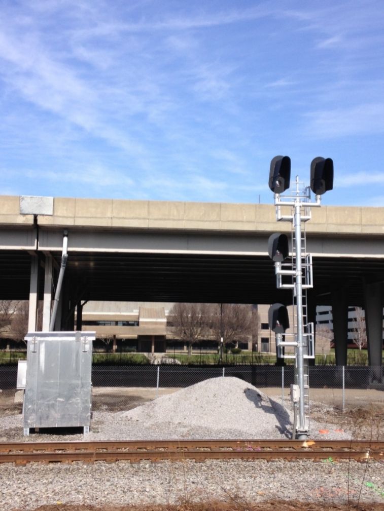
While my cousin was preflighting the 177, I noticed that a mow crew was installing a new signal right next to the airport, just east of Pavement in Lancaster. I tried to take a picture but the sun was directly in front of me. But I have two videos instead.

Departure [eastbound]:
Image

Arrival:
Image

It's taken me nearly two hours to get these videos loaded into photobucket. Please let me know if they are viewable. Photobucket gave me a real hard time [slooooow] getting them uploaded.
 #1369449  by SST
 
I forgot to mention that the signals between Pavement and Cemetery was still standing this afternoon. But I did see a couple of trucks near it. Get your pictures!
 #1377571  by SST
 
I was riding my bike along the water front on Saturday and noticed that an additional [new] set of vader signals have been installed about 200 feet north of 2N on the CSX/Amtrak Niagara Branch line. The original vader signals are still in place. The new lights are turned perpendicular and are not functioning at the moment.

Image
 #1377624  by ctclark1
 
lakeshoredave wrote:Any idea when the signals on CSX in Upstate NY will be changed to the new PTC conforming signals?
You'll have to be more specific about your reference to "Upstate"... Are you referring to the New York City style where everything north of Westchester County is "Upstate", or are you talking about the Adirondack area?

EDIT: The reason I ask is because the changeover on the mainline is well underway. Upgrades on the Rochester Subdivision (Syracuse to Buffalo, essentially) are moving westward - from at least east Rochester (possibly west Rochester) to Syracuse has all been completed, with installations west of Rochester moving right along but not yet cut in. I have personally seen the new signals installed as far as Colby Rd but not yet active, and the posts just above yours also include pictures at Pavement Rd in Lancaster, indicating that they are nearing completion on installations all the way to the end of the Rochester Sub at the Buffalo Terminal Sub. Also evidenced is the Niagara Sub... However I do not know the status of changeovers on other subdivisions running into the "north country" such as the Montreal and St. Lawrence subs.

For specific dates as to when the vaders will become active and the searchlights removed, take a look through recent pages of the thread, Nick may have posted proposed cutover dates for the new system, or they may not be planned yet... This thread has become fairly inactive as of late which tells me things are slowing down as they near completion... They may be planning one large cutover for everything remaining between Rochester and Buffalo at this point.
 #1378457  by smph50
 
Hi All!
When "TOMT7X" Dave started this discussion on Feb 09, 2012, I said to myself what a great idea! I gotta start doing that in the Buffalo area like the great job Scot L. did in the Rochester region. I had "bagged" one bridge way back in 2002 and a few way back on slides but nothing new until June 2012 when I got 3. I figured I had plenty of time until read about the bridge at MP-427.1, I knew time was running out!
SST wrote:Feb 3, 2016. I forgot to mention that the signal bridge between Pavement and Cemetery was still standing this afternoon. But I did see a couple of trucks near it. Get your pictures!
CSX is all over the Buffalo division pouring foundations, adding new infrastructure and erecting signals. All of the CSX signal crew guys I spoke with were very helpful and indicated that most of the old bridges will be removed by the end of May.

I used the 1998 Conrail Chicago Line Track Chart as a reference for mile posts and control points as I started west from the Genesee Co./Erie Co. line MP-419 for 17 miles to MP-436 at the west end of Frontier Yard. Some of the bridges are inaccessible to photograph without trespassing but I have indicated their status below.

MP-419.0 Eastbound & Westbound Automatic - 3592 Crittenden Road overpass, 14004. I got lucky and caught a westbound oil train with a high green. Image

MP-421.2 Eastbound & Westbound Automatic - 12405 Reinhardt Road, 14004. Inaccessible but still visible on satellite view.

MP-423.2 (WAS) CP-423 - 11346 Walden Ave, 14004. Removed and replaced with Safetran wayside signals in 2002 after a derailment.

MP-423.4 (EAS) CP-423 - 11241 Walden Ave, 14004. New signals at MP-423.2 can be seen down the track. I was granted access by farmer at his private crossing. Removed and replaced in November 2015.
Image

Image

MP-425.0 Eastbound & Westbound Automatic - 4437 Walden Ave, 14086. Removed and replaced February 2016.

MP-427.1 Eastbound & Westbound Automatic - 3979 Walden Ave, 14086. New signals going up.
Image

Image

Image

Image

MP-429.8 – 3317 Walden Ave, 14086. Looking East toward westbound bridge, CSX had a large crew. Second runner in the foreground is still used to service 84 Lumber.
Image

MP-429.8 (WAS) CP-429 – 3317 Walden Ave, 14043. New relay hut and infrastructure.
Image

Image

MP-429.0 (EAS) CP-429 -3277 Walden Ave, 14043. Transit Road 6 track bridge. This is where the NYC had their Depew Station which lasted until the 70’s. Four railroads within 1/4 mile crossed US-78, Transit Road in this location. Going south on Transit from the 6 Track NYC bridge is the 3 Track Lehigh Valley bridge, then the 2 Track DL&W bridge and finally the 3 Track Erie bridge. In the 1900’s, Depew had more taverns per capita in the entire United States just to support the huge railroad community, Ha! 2015 street view available.
Image

The NYC Depew Station was to the left where the brick building is now.
Image

Image

Image

Looking south west, the Lehigh Valley’s Niagara Junction was just to the right of the concrete towers.
Image

MP-431.0 (WAS) CP-431 - 3005 Walden Ave, 14043. The Conrail named “A” Industrial Runner was the NYC connector to the West Shore Line. 2011 street view available.
Image

Image

Image

MP-431.0 “A” Industrial Runner which was the lead to the West Shore Line.
Image

Image

View from MP-431.2 bridge looking east from the Amtrak Station platform.
Image

MP-431.2 (EAS) CP-431 – 53 Ellicott Road, Depew, 14043. 2011 street view available. MP-431.0 (WAS) in the background.
Image

Image

Image

MP-431.2 looking west toward the Depew Amtrak Station. 2011 street view available.
Image

MP-432.8 (WAS) - 40 Ellicott Road, Cheektowaga, 14227. This is near the Forks Firehall on Broadway. This is considered the east end of the NYC Frontier Yard. 2011 street view available.
Image

Image

Image

MP-433.1 (EAS) CP-433 - 3227 Broadway, Cheektowaga, 14227. 2015 street view available.
Image

Image

MP-434.2 (WAS) CP-434 - 2641 Broadway, Cheektowaga, 14227. This is the last cantilever bridge in the Buffalo division. 2015 street view available.
Image

Image

Image

Image

MP-435.6 – 1903 Old Broadway, Buffalo, 14212. West end of Frontier Yard. Linde Air Products in the background. 2014 street view available.
Image

MP-435.6 – 1903 Old Broadway, Buffalo, 14212. Looking west toward MP-436 with NYC Central Terminal in the background.
Image

MP-436.0 Eastbound & Westbound Automatic - 4 Reiman Street, Buffalo, 14206. East end of NYC Stockyard. 2012 street view available.
Image

Image

Image

Image

Image

Image

MP-437 (WAS) CP-437 - 1200 William St, Buffalo, 14240 is behind Central Terminal. There is a new aluminum bridge where the “Belt Line” and "Track 3" - "Buffalo Terminal Sub" the old Compromise Branch come together.

Hopefully I will still have some time to backtrack and get some better shots in the afternoon of the eastbound bridges. I will also try to verify if the bridges I missed are still standing but with the progress that CSX is making I know their days are numbered.

Sincerely, Scott H.
Last edited by smph50 on Tue Apr 05, 2016 8:56 am, edited 1 time in total.
 #1378528  by ctclark1
 
Great shots! But a couple comments:
EAS and WAS refer to Eastbound and Westbound Absolute Signals... These descriptions are correct where you're referring to the signals guarding CP's... The signals with number plates in your images, that share bridges or masts with both directions, would be Automatics, and are usually not presented by eastbound or westbound.

Unless they're resetting the subdivisions (which I've seen or heard nothing about at all) everything from CP-296 to CP-429 is the "Rochester" Subdivision (with the obvious exception of the West Shore Sub), CP-429 across DRAW to CP-2 is Buffalo Terminal Sub. You're more or less correct that the Belt and Niagara subs split at CP-437, however CSX hasn't referred to the Compromise branch officially since the takeover that I know of, they simply refer to it as track 3 of the Buffalo Terminal sub. I've heard nothing of a Lancaster sub, Depew sub, Forks sub, or anything of the like.

But other than that, like I said, great documentation of the soon to be gone structures.
 #1378538  by Otto Vondrak
 
Great shots, Scott, now I'm motivated to get out and shoot those Buffalo-area bridges before they are gone for good...

-otto-
 #1378628  by nick_anshant
 
The Rochester Subdivision is now from and including CP 296 to and including CP 382. The Buffalo Terminal Subdivision is from but not including CP 382 to and including CP 15. This change went into effect on May 18, 2013.

Nick


ctclark1 wrote:Great shots! But a couple comments:
EAS and WAS refer to Eastbound and Westbound Absolute Signals... These descriptions are correct where you're referring to the signals guarding CP's... The signals with number plates in your images, that share bridges or masts with both directions, would be Automatics, and are usually not presented by eastbound or westbound.

Unless they're resetting the subdivisions (which I've seen or heard nothing about at all) everything from CP-296 to CP-429 is the "Rochester" Subdivision (with the obvious exception of the West Shore Sub), CP-429 across DRAW to CP-2 is Buffalo Terminal Sub. You're more or less correct that the Belt and Niagara subs split at CP-437, however CSX hasn't referred to the Compromise branch officially since the takeover that I know of, they simply refer to it as track 3 of the Buffalo Terminal sub. I've heard nothing of a Lancaster sub, Depew sub, Forks sub, or anything of the like.

But other than that, like I said, great documentation of the soon to be gone structures.
 #1378634  by smph50
 
Thank you ctclark and Otto for your kind words on my work!

I figured using the old 1998 Conrail track chart would give me obsolete naming trouble but it really did help for mileage points. Many of the old heads in the Society still refer to the Conrail nomenclature when they talk of the "good ole days."

ctclark, your description of signal identification is excellent, I have made caption corrections and will certainly make note of that for future photo's.

Otto, you have a long drive, I hope you get a great day weather-wise! Seemed like every time I had a day to go signal hunting, the sun disappeared.

Sincerely, Scott H.
Last edited by smph50 on Tue Apr 05, 2016 8:57 am, edited 1 time in total.
 #1378635  by charlie6017
 
Excellent work Scott, thanks for taking the time to get out there and record these signals and bridges before
they are gone. Also a thanks again to Scot Lawrence for grabbing his shots around Rochester. These new Darth
Vader signals just don't have the same appeal!

Charlie
 #1378913  by MACTRAXX
 
ctclark1 wrote:
lakeshoredave wrote:Any idea when the signals on CSX in Upstate NY will be changed to the new PTC conforming signals?
You'll have to be more specific about your reference to "Upstate"... Are you referring to the New York City style where everything north of Westchester County is "Upstate", or are you talking about the Adirondack area?

EDIT: The reason I ask is because the changeover on the mainline is well underway. Upgrades on the Rochester Subdivision (Syracuse to Buffalo, essentially) are moving westward - from at least east Rochester (possibly west Rochester) to Syracuse has all been completed, with installations west of Rochester moving right along but not yet cut in. I have personally seen the new signals installed as far as Colby Rd but not yet active, and the posts just above yours also include pictures at Pavement Rd in Lancaster, indicating that they are nearing completion on installations all the way to the end of the Rochester Sub at the Buffalo Terminal Sub. Also evidenced is the Niagara Sub... However I do not know the status of changeovers on other subdivisions running into the "north country" such as the Montreal and St. Lawrence subs.

For specific dates as to when the vaders will become active and the searchlights removed, take a look through recent pages of the thread, Nick may have posted proposed cutover dates for the new system, or they may not be planned yet... This thread has become fairly inactive as of late which tells me things are slowing down as they near completion... They may be planning one large cutover for everything remaining between Rochester and Buffalo at this point.
CTC: The Upstate vs. Downstate divide geographically here in NYS has always interested me. Here on Long Island
you have some people that think anything north of the Bronx is "Upstate"...It is not just New York City...

To me what could be considered the true dividing line between what is "Downstate" as opposed to "Upstate" is the
area of Interstate 84 from Port Jervis across Orange County and the lower portion of Dutchess County from Beacon
curving SE into the east end of Putnam County near Brewster before reaching the NY-CT state line west of Danbury.

I have a big interest in NYS geography and the transition from "Downstate" to "Upstate" is Orange County and the
lower portion of Dutchess County - the Newburgh/Beacon area in the Hudson Valley. Anything further south is in
the "Downstate" region of New York and anything north of that is "Upstate". Poughkeepsie can be considered in
either region but to me it is where "Upstate" truly begins.

Back to the topic: Great pictures of the former NYC signal bridges that are intact and still in use.
I noticed the Conrail style mile numbers still in use on the signal boxes. Glad to see that the old milepost
headstones are still intact and in wide use - they are one of my favorite features along the route. One question:
I noticed some mile markers in WNY reading from "C" - are they miles from Chicago as I suspect?

MACTRAXX
 #1378976  by ctclark1
 
smph50 wrote:I figured using the old 1998 Conrail track chart would give me obsolete naming trouble but it really did help for mileage points. Many of the old heads in the Society still refer to the Conrail nomenclature when they talk of the "good ole days."
I see... What you're using out of the track charts is simply the "town" that Conrail considered the line to run through (though not always the "proper" town name), it had nothing to do with divisions at the time.

Nick, thank you for that info, I did some searching and managed to find one obscure site that backs this up (lists the dispatch desks)... As with Scott H, this is what I get for referencing the 2004 ETT... Unfortunately the most recent I can find.
 #1380576  by SST
 
I went out to pick up my boat today and noticed a few things. At Colby Rd, the tower is still standing. Vador signals are still turned into the track.

The two towers just west of County line rd are also still standing. I barely made out a Vador signal. I assumed it was turned into the track as well.
  • 1
  • 57
  • 58
  • 59
  • 60
  • 61
  • 63