Railroad Forums 

  • Batavia map (and new map webpage)

  • Pertaining to all railroading subjects, past and present, in New York State.
Pertaining to all railroading subjects, past and present, in New York State.

Moderator: Otto Vondrak

 #493690  by TB Diamond
 
Scot:

First of all, congratulations on your excellent NYS rail map work.

The connection remnant from the LVRR MT over to the E. Peanut is pretty much buried in the dirt near the depot site. Then, as it continues east of the depot site it is obscured by weeds and brush. Therefore, I doubt that it will show on the "bird's eye" views.

Years ago there was a curved line of evergreen trees that delineated the connection north of NY Rt. 63. They may still be there, but I did not pay attention to this last Fall when in Batavia.

 #493741  by howie729
 
I am not sure exactly where but I was told by a local that there used to be a third underpass that used to flood all the time that was ripped out. I know that there are still the CSX mainline underpass and the old LVR underpass over Rt 98. He told me that the third underpass was farther south but I don't see it on any of the old maps

Maybe he is wrong. But I did want to mention it because it may be relavent.

 #493845  by Scott K
 
Could the third underpass be the DL&W one in North Alexander? I haven't been through there for a couple of years, but I honestly can't remember if the bridge was still there last time we went by. The only bridge I do remember being taken out was the one over the main just west of the NYC depot. Anyone know any details about that one?

Scott K.

 #494119  by TB Diamond
 
The highway overpass just west of the Batavia Water Works was abandoned in 1979 or 1980. Subsequently demolished, first the portion that passed over the former Lehigh Valley RR and later, that portion passing over what is now the CSX MT.

 #494376  by lvrr325
 
The NYC built several stations as a result of mainline relocations "late" probably one of the latest the former East Syracuse station, built in the mid-late '60s. Herkimer is another example, although I think it's earlier than Batavia. There are numerous NYC mainline relocations across New York state.

The LV Batavia station was basically across the street from the relocated NYC, some of the foundation is still there. Burned in the 70's if I remember right. There's a photo from the torn-down highway overpass in LV In Color V1 and it shows in the background.

The DL&W actually passes through what is now Darien Lake theme park, it's that much further south.

 #494386  by TB Diamond
 
Have the information written down in my notes, but I am sure that the Lehigh Valley Railroad Batavia depot was destroyed in 1979 by a fire started by vagrants.

 #494625  by WNYRailfan
 
As per a request from Scot, I have posted some of my Batavia, NY pictures.

I have included some information in the captions as to the location of the photo and the date it was taken.

The NYC "new" ROW was built starting in 1951 and ending in 1957.
The line officially opened on April 2, 1957.
The "old" line running through downtown officially had its last train on April 12, 1957.

http://community.webshots.com/user/railfanbrplv

 #494663  by alsorailfan
 
Nice pictures!! Good info! Thanks!

chris

 #523029  by dj_paige
 
Following Scot's map, I found the DLWR Roundhouse (formerly a NYC roundhouse) the other day, just west of Evans St.

The bridge over the creek there is clearly a two-track bridge, yet the maps indicate that this is where the four-track NYC crossed the creek. Was there another bridge in this location carrying the other two tracks? If so, where was it in relation to the existing bridge?

 #523087  by Lehighton_Man
 
Awesome maps Scott.
Loved the Lehigh Segiment.
1 question though.
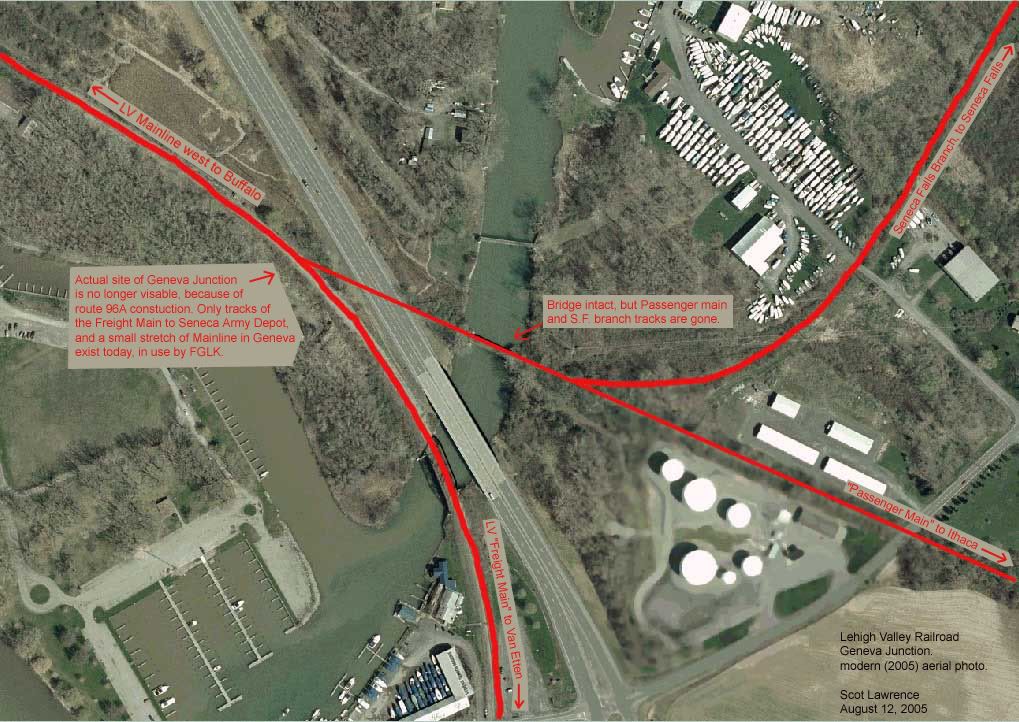
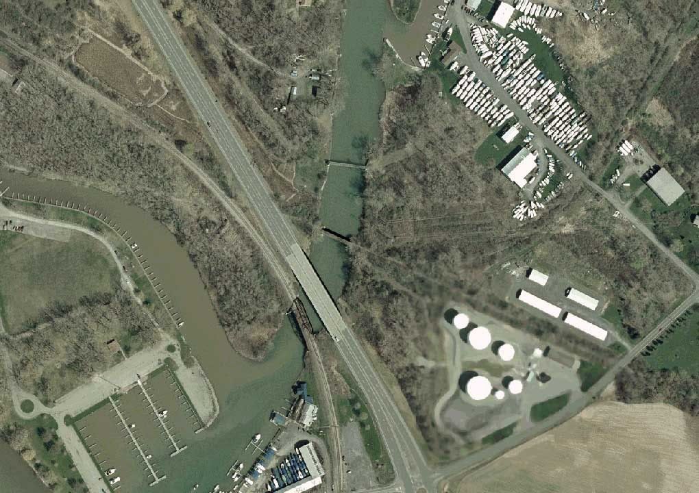
I have traced the remaining portion of the freight main down to Kendida, but where your maps say, i dont quite see where the Ithaca Passenger main, and the Seneca Falls Branch, bled off of the main line? I see it in the map, but if you could use a Live Areal image that'd be awesome.
Thanks.
Sean

 #523117  by TB Diamond
 
Lehighton:

Until Scot posts a aerial view for you:

The Ithaca Branch came off the MT at Geneva Jct. and crossed NY Rt. 96A just north of the Seneca Canal. A short distance SE of the junction the Seneca Falls Branch left the Ithaca Branch. Compass direction is used here. Last that I knew, a few years ago, the Ithaca Branch bridge over the Seneca Canal remained in place.

 #523170  by scottychaos
 
Lehighton_Man wrote:Awesome maps Scott.
Loved the Lehigh Segiment.
1 question though.
I have traced the remaining portion of the freight main down to Kendida, but where your maps say, i dont quite see where the Ithaca Passenger main, and the Seneca Falls Branch, bled off of the main line? I see it in the map, but if you could use a Live Areal image that'd be awesome.
Thanks.
Sean
hows this?

Image

Image

Image

Scot

 #523207  by TB Diamond
 
Scot:

In your description above you mention that the site of Geneva Jct. is no longer visable. When I was back east last Fall I walked the area and noted that the foundation of the Geneva Jct. tower was extant, but slowly disappearing into the foliage. The signal tower for e/b movement was also still extant but was being crowded by fast growing trees.

However, should one not have been in the area before one would be hard-pressed to tell that an important rail junction once occupied the site.

 #523252  by Kendaia1
 
TB is correct, the concrete foundation of the Geneva Junction Tower is still there next to the tracks. When I was very young I remember the Tracks of the Ithaca branch crossing 96A, but I don't remember if the tower was still there of not. I am surprised the bridge over the canal is still there.

Speaking of towers, I remember the tower in the Geneva Yard you would see when going into Geneva on 5&20, near the LV bridge over Pre-Emption St, about where Suburban Propane is now. Did that tower belong to the LV or NYC?